TopoQuest Logo
Do you find TopoQuest useful?
Help keep TopoQuest running and adding new maps/features by donating!
Bitcoin:  19c7KJd3qBynnjoSw5npx9KScwjBe4ifkT
Litecoin:  LXs6TkuXGGXo1vDsWCkWVdjQX94eUKd6ui
Home View Maps Find Maps Find Places Resources & Links


Jerome, Arkansas Topographic Map

USGS Map Title: Jerome, AR
USGS Map MRC: 33091D4
DRG (GeoTIFF) Download: o33091d4.tif


Neighboring USGS Topographic Map Quads:


  Collins, AR  
33091E5
 

  McGehee South, AR  
33091E4
 

  Halley, AR  
33091E3
 

  Line, AR  
33091D5
 

  Jerome, AR  
33091D4
 

  Macon Lake, AR  
33091D3
 

  Snyder, AR  
33091C5
 

  Montrose, AR  
33091C4
 

  Lake Village, AR  
33091C3


Map MRC Location:

N34°
W92°
N34°
W91°
H8 H7 H6 H5 H4 H3 H2 H1
G8 G7 G6 G5 G4 G3 G2 G1
F8 F7 F6 F5 F4 F3 F2 F1
E8 E7 E6 E5 E4 E3 E2 E1
D8 D7 D6 D5 D4 D3 D2 D1
C8 C7 C6 C5 C4 C3 C2 C1
B8 B7 B6 B5 B4 B3 B2 B1
A8 A7 A6 A5 A4 A3 A2 A1
N33°
W92°
N33°
W91°

Jerome, AR USGS 1:24K Topographic Map Preview:
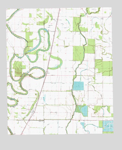
Jerome, AR USGS Topographic Map
Click on map above to begin viewing in our Map Viewer.

This topographic map contains these locations and features:
Feature Name Type Latitude Longitude GNIS ID View Map
Bellaire AcademySchoolN33.4890°W91.3857°61711View Map
Bethel TempleChurchN33.4032°W91.4923°78970View Map
Black Pond SloughGutN33.4946°W91.3951°46676View Map
Decker (historical)Populated PlaceN33.4890°W91.4396°61710View Map
Deep ElmPopulated PlaceN33.4912°W91.3996°57633View Map
Dermott Municipal AirportAirportN33.4880°W91.4417°83676View Map
Dickson Brake (historical)SwampN33.4851°W91.4598°78995View Map
HudspethPopulated PlaceN33.4371°W91.4526°57954View Map
JeromePopulated PlaceN33.3996°W91.4701°77373View Map
Jerome Relocation Center (historical)BuildingN33.4117°W91.4611°2786154View Map
Lake WallaceReservoirN33.4580°W91.4561°80473View Map
Lake Wallace DamDamN33.4551°W91.4785°80472View Map
Little Click BayouStreamN33.4493°W91.4104°51224View Map
Morning Star ChurchChurchN33.4379°W91.4557°52199View Map
Oak Grove ChurchChurchN33.3882°W91.3821°52896View Map
Pleasant Grove CemeteryCemeteryN33.4779°W91.4434°53527View Map
Pleasant Grove ChurchChurchN33.4768°W91.4437°53534View Map
Silver Mound CemeteryCemeteryN33.4159°W91.4673°79095View Map
Silver Mound ChurchChurchN33.4129°W91.4629°78368View Map
Town of JeromeCivilN33.3979°W91.4704°2405916View Map
Township of BartholomewCivilN33.4989°W91.4985°66508View Map

Note: Coordinates in the location and feature list above are referenced to NAD83 datum.


Copyright (C) 2008-2025 Ryan Niemi / Sunset Dynamics ... All Rights Reserved