TopoQuest Logo
Do you find TopoQuest useful?
Help keep TopoQuest running and adding new maps/features by donating!
Bitcoin:  19c7KJd3qBynnjoSw5npx9KScwjBe4ifkT
Litecoin:  LXs6TkuXGGXo1vDsWCkWVdjQX94eUKd6ui
Home View Maps Find Maps Find Places Resources & Links


Moquino, New Mexico Topographic Map

USGS Map Title: Moquino, NM
USGS Map MRC: 35107B3
DRG (GeoTIFF) Download: o35107b3.tif


Neighboring USGS Topographic Map Quads:


  Laguna Canoneros, NM  
35107C4
 

  Marquez, NM  
35107C3
 

  La Gotera, NM  
35107C2
 

  Seboyeta, NM  
35107B4
 

  Moquino, NM  
35107B3
 

  Arch Mesa, NM  
35107B2
 

  Laguna, NM  
35107A4
 

  Mesita, NM  
35107A3
 

  Mesa Gigante, NM  
35107A2


Map MRC Location:

N36°
W108°
N36°
W107°
H8 H7 H6 H5 H4 H3 H2 H1
G8 G7 G6 G5 G4 G3 G2 G1
F8 F7 F6 F5 F4 F3 F2 F1
E8 E7 E6 E5 E4 E3 E2 E1
D8 D7 D6 D5 D4 D3 D2 D1
C8 C7 C6 C5 C4 C3 C2 C1
B8 B7 B6 B5 B4 B3 B2 B1
A8 A7 A6 A5 A4 A3 A2 A1
N35°
W108°
N35°
W107°

Moquino, NM USGS 1:24K Topographic Map Preview:
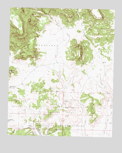
Moquino, NM USGS Topographic Map
Click on map above to begin viewing in our Map Viewer.

This topographic map contains these locations and features:
Feature Name Type Latitude Longitude GNIS ID View Map
117 Mesita InterchangeCrossingN35.1609°W107.3206°924450View Map
Anaconda Water WellWellN35.1934°W107.3139°918573View Map
Arroyo MoquinoStreamN35.1342°W107.3475°897651View Map
Caņada de Pedro PadillaValleyN35.1442°W107.2550°898258View Map
Caņon de Pedro PadillaValleyN35.2378°W107.2914°942024View Map
Cerro de la CelosaSummitN35.1875°W107.3731°898278View Map
Cerro NegroSummitN35.2031°W107.3450°897898View Map
Diablo Water WellWellN35.2042°W107.3192°918865View Map
Gavilan MesaSummitN35.1514°W107.3014°889382View Map
Jackpile MineMineN35.1359°W107.3323°890391View Map
Jackpile Number 1 Water WellWellN35.1262°W107.3409°918505View Map
Jackpile Number 2 Water WellWellN35.1253°W107.3398°918504View Map
JJ Number 1MineN35.1828°W107.3198°916582View Map
L Bar MineMineN35.1787°W107.3242°916904View Map
L-Bar 2 Water WellWellN35.1848°W107.3142°918712View Map
LJ 205 Water WellWellN35.1898°W107.3250°918511View Map
Lobo CampLocaleN35.1981°W107.2634°891231View Map
Lobo Camp Water WellWellN35.1995°W107.2634°918512View Map
Mesa del LoboSummitN35.2114°W107.2900°898011View Map
MoquinoPopulated PlaceN35.1725°W107.3689°899803View Map
Moquino Census Designated PlaceCensusN35.1801°W107.3701°2584156View Map
Number 1 Water WellWellN35.1928°W107.3114°918522View Map
Number 10 Water WellWellN35.2184°W107.3164°919797View Map
Number 11 Water WellWellN35.2203°W107.3137°919798View Map
Number 12 Water WellWellN35.2223°W107.3114°919799View Map
Number 13 Water WellWellN35.2259°W107.3067°919800View Map
Number 14 Water WellWellN35.2300°W107.3012°918528View Map
Number 16 Water WellWellN35.2273°W107.3109°918526View Map
Number 2 Water WellWellN35.1928°W107.3170°918523View Map
Number 3 Water WellWellN35.1914°W107.3209°919805View Map
Number 4 Water WellWellN35.1531°W107.3539°919803View Map
Number 4 Water WellWellN35.1956°W107.3184°918524View Map
Number 5 Water WellWellN35.1981°W107.3195°918525View Map
Number 6 Water WellWellN35.1923°W107.3145°918521View Map
Number 7 Water WellWellN35.2084°W107.3195°919796View Map
Number 8 Water WellWellN35.2331°W107.2975°918529View Map
Number 8A Water WellWellN35.2289°W107.2964°918527View Map
Old Water WellWellN35.1862°W107.3275°919795View Map
Paguate Census Designated PlaceCensusN35.1356°W107.3640°2409015View Map
Rio MoquinoStreamN35.1342°W107.3475°923662View Map
Rusty Water WellWellN35.1698°W107.2881°918595View Map
Saint Anthony MineMineN35.1595°W107.3062°894266View Map
Saint Anthonys Shaft Number TwoMineN35.1614°W107.3173°916424View Map
Seboyeta ProjectMineN35.1831°W107.3684°917885View Map
Sohio A1 Water WellWellN35.1731°W107.3178°918587View Map
Sohio L-Bar Tailings DamDamN35.1834°W107.3389°924177View Map
Sohio Uranium MineMineN35.1834°W107.3317°916907View Map
Well Number 9 Water WellWellN35.2159°W107.3198°918583View Map
Wind WhipMineN35.1417°W107.3423°916905View Map
Woodrow MineMineN35.1314°W107.3148°896757View Map

Note: Coordinates in the location and feature list above are referenced to NAD83 datum.


Copyright (C) 2008-2024 Ryan Niemi / Sunset Dynamics ... All Rights Reserved