TopoQuest Logo
Do you find TopoQuest useful?
Help keep TopoQuest running and adding new maps/features by donating!
Bitcoin:  19c7KJd3qBynnjoSw5npx9KScwjBe4ifkT
Litecoin:  LXs6TkuXGGXo1vDsWCkWVdjQX94eUKd6ui
Home View Maps Find Maps Find Places Resources & Links


Marquez, New Mexico Topographic Map

USGS Map Title: Marquez, NM
USGS Map MRC: 35107C3
DRG (GeoTIFF) Download: o35107c3.tif


Neighboring USGS Topographic Map Quads:


  El Dado Mesa, NM  
35107D4
 

  Laguna Seca, NM  
35107D3
 

  Cerro Tinaja, NM  
35107D2
 

  Laguna Canoneros, NM  
35107C4
 

  Marquez, NM  
35107C3
 

  La Gotera, NM  
35107C2
 

  Seboyeta, NM  
35107B4
 

  Moquino, NM  
35107B3
 

  Arch Mesa, NM  
35107B2


Map MRC Location:

N36°
W108°
N36°
W107°
H8 H7 H6 H5 H4 H3 H2 H1
G8 G7 G6 G5 G4 G3 G2 G1
F8 F7 F6 F5 F4 F3 F2 F1
E8 E7 E6 E5 E4 E3 E2 E1
D8 D7 D6 D5 D4 D3 D2 D1
C8 C7 C6 C5 C4 C3 C2 C1
B8 B7 B6 B5 B4 B3 B2 B1
A8 A7 A6 A5 A4 A3 A2 A1
N35°
W108°
N35°
W107°

Marquez, NM USGS 1:24K Topographic Map Preview:
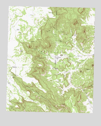
Marquez, NM USGS Topographic Map
Click on map above to begin viewing in our Map Viewer.

This topographic map contains these locations and features:
Feature Name Type Latitude Longitude GNIS ID View Map
Agua de Caņon SecoStreamN35.3192°W107.2525°897571View Map
Agua del CaņoncitoSpringN35.3349°W107.2989°885583View Map
Arroyo HondoStreamN35.3111°W107.2764°897641View Map
Arroyo PuertecitaStreamN35.2992°W107.2809°897665View Map
B-52 HillSummitN35.3445°W107.3564°885964View Map
Caņon de CalifiaValleyN35.2503°W107.3428°898263View Map
Caņon de Juan TafoyaLocaleN35.3144°W107.3019°935167View Map
Caņon de MarquezValleyN35.3192°W107.2528°897826View Map
Caņon de San MateoValleyN35.3148°W107.3120°897761View Map
Caņon de Santa RosaValleyN35.3192°W107.2525°904554View Map
Caņon SecoValleyN35.3111°W107.2642°897844View Map
Caņoncito de la PrimallasValleyN35.3381°W107.2814°897857View Map
Canoncito ValleyValleyN35.3348°W107.2820°897862View Map
Cebolleta GrantCivilN35.3214°W107.3142°902801View Map
Cerrito NegroSummitN35.2989°W107.2695°897866View Map
Cerro MarquezSummitN35.3220°W107.3562°897894View Map
Cerro VacioSummitN35.3064°W107.2512°897907View Map
Cueva de los NoviosLocaleN35.3017°W107.3059°899598View Map
Diablo SpringSpringN35.2929°W107.3644°888362View Map
El BosqueForestN35.3128°W107.2670°888791View Map
Gallegos BridgeBridgeN35.2911°W107.2837°928943View Map
La Canada BonitaValleyN35.3214°W107.2695°890779View Map
La Canada El SaladoValleyN35.3000°W107.2784°890780View Map
La LagunaLakeN35.3181°W107.2748°890816View Map
La Mesa del Caņon SecoSummitN35.2803°W107.2953°899708View Map
La SierritaSummitN35.2625°W107.2787°899710View Map
Laguna QuebradaReservoirN35.3483°W107.3637°897989View Map
Laguna SantiagoLakeN35.2904°W107.3689°897991View Map
LagunitaReservoirN35.3649°W107.3456°890871View Map
Las CarretasRidgeN35.3445°W107.3270°890945View Map
Las Cuevas de MarquezMineN35.3109°W107.3006°890950View Map
Loma LargaSummitN35.3070°W107.2737°899730View Map
MarquezPopulated PlaceN35.3145°W107.3025°923720View Map
Marquez Canyon MineMineN35.3145°W107.3203°917497View Map
Marquez W Water WellWellN35.2986°W107.2800°919808View Map
Mesa BlancaSummitN35.3384°W107.2631°898014View Map
Mesa de CaņoncitoSummitN35.3284°W107.2862°899767View Map
Mesa MarquezSummitN35.3092°W107.2939°899781View Map
Mesita RedonditaLocaleN35.3170°W107.3056°924451View Map
MMW-1 Water WellWellN35.3239°W107.3278°921498View Map
Moses CanyonValleyN35.3356°W107.3006°892251View Map
Moses SpringSpringN35.3463°W107.3169°892252View Map
Ojo de las PrimallasSpringN35.3425°W107.2892°898085View Map
Ojo EstaliandoSpringN35.3331°W107.3429°898094View Map
Ojo los RechuelosSpringN35.3680°W107.3114°898092View Map
Ojo MarquezSpringN35.3251°W107.3386°898097View Map
Ojo San MateoSpringN35.3148°W107.3332°898102View Map
Ojo Tecolote SpringsSpringN35.2551°W107.3694°898104View Map
PuertecitaSummitN35.2592°W107.2925°893523View Map
Puerto BridgeBridgeN35.2739°W107.2617°929019View Map
Puerto GrandeCliffN35.2775°W107.2659°893538View Map
Puerto GrandeLocaleN35.2770°W107.2575°924522View Map
Rincon BlancoAreaN35.3423°W107.2781°893922View Map
Rincon del OsoCliffN35.3114°W107.2875°893917View Map
Rincon HondoValleyN35.2973°W107.2920°893937View Map
San Antonio ValleyValleyN35.2528°W107.2562°930421View Map
Santa Rosa PeaksSummitN35.3567°W107.2775°910788View Map

Note: Coordinates in the location and feature list above are referenced to NAD83 datum.


Copyright (C) 2008-2025 Ryan Niemi / Sunset Dynamics ... All Rights Reserved