TopoQuest Logo
Do you find TopoQuest useful?
Help keep TopoQuest running and adding new maps/features by donating!
Bitcoin:  19c7KJd3qBynnjoSw5npx9KScwjBe4ifkT
Litecoin:  LXs6TkuXGGXo1vDsWCkWVdjQX94eUKd6ui
Home View Maps Find Maps Find Places Resources & Links


Horse Mesa Dam, Arizona Topographic Map

USGS Map Title: Horse Mesa Dam, AZ
USGS Map MRC: 33111E3
DRG (GeoTIFF) Download: o33111e3.tif


Neighboring USGS Topographic Map Quads:


  Mine Mountain, AZ  
33111F4
 

  Four Peaks, AZ  
33111F3
 

  Theodore Roosevelt Dam, AZ  
33111F2
 

  Mormon Flat Dam, AZ  
33111E4
 

  Horse Mesa Dam, AZ  
33111E3
 

  Pinyon Mountain, AZ  
33111E2
 

  Goldfield, AZ  
33111D4
 

  Weavers Needle, AZ  
33111D3
 

  Iron Mountain, AZ  
33111D2


Map MRC Location:

N34°
W112°
N34°
W111°
H8 H7 H6 H5 H4 H3 H2 H1
G8 G7 G6 G5 G4 G3 G2 G1
F8 F7 F6 F5 F4 F3 F2 F1
E8 E7 E6 E5 E4 E3 E2 E1
D8 D7 D6 D5 D4 D3 D2 D1
C8 C7 C6 C5 C4 C3 C2 C1
B8 B7 B6 B5 B4 B3 B2 B1
A8 A7 A6 A5 A4 A3 A2 A1
N33°
W112°
N33°
W111°

Horse Mesa Dam, AZ USGS 1:24K Topographic Map Preview:
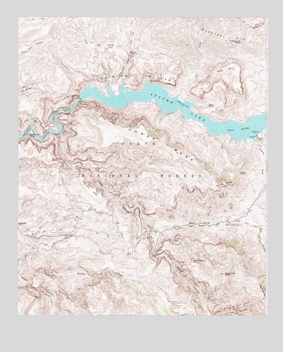
Horse Mesa Dam, AZ USGS Topographic Map
Click on map above to begin viewing in our Map Viewer.

This topographic map contains these locations and features:
Feature Name Type Latitude Longitude GNIS ID View Map
Adams CampLocaleN33.6131°W111.3357°25523View Map
Alder CreekStreamN33.5992°W111.3226°25572View Map
Apache LakeReservoirN33.5919°W111.3138°25703View Map
Apache Lake CampgroundLocaleN33.5770°W111.2537°36920View Map
Apache Lake Marina Recreation SiteLocaleN33.5731°W111.2579°41248View Map
Apache Lake ResortLocaleN33.5753°W111.2565°41244View Map
Arizona Highway Maintenance Fish Creek YardLocaleN33.5389°W111.2690°43235View Map
Ash CreekStreamN33.5925°W111.2943°25783View Map
Black Cross ButteSummitN33.5653°W111.3587°26383View Map
Black Cross ButteSummitN33.5175°W111.2712°45629View Map
Bronco ButteSummitN33.5550°W111.2715°26763View Map
Coronado MesaSummitN33.5550°W111.3418°27967View Map
Coronado Mesa (historical)SummitN33.5550°W111.3418°45639View Map
Coronado Summit (historical)SummitN33.5231°W111.2868°45640View Map
Cottonwoods SpringSpringN33.6147°W111.2636°28061View Map
Crabtree SpringSpringN33.5597°W111.2608°28143View Map
Crabtree WashStreamN33.5734°W111.2560°28145View Map
Crabtree Wash Recreation ResidencesLocaleN33.5723°W111.2543°40816View Map
Fish CreekStreamN33.5764°W111.3537°36976View Map
Fish Creek (historical)Populated PlaceN33.5334°W111.3062°36977View Map
Fish Creek CanyonValleyN33.5767°W111.3537°29021View Map
Fish Creek MountainSummitN33.5073°W111.2512°45630View Map
Fish Creek PeakSummitN33.5231°W111.2868°29023View Map
Fish Creek VistaLocaleN33.5339°W111.3143°2044442View Map
Goat MountainSummitN33.6056°W111.2662°29358View Map
Hells Hole SpringSpringN33.5187°W111.3704°37000View Map
Horse MesaSummitN33.5731°W111.3079°30149View Map
Horse MesaPopulated PlaceN33.5831°W111.3554°30147View Map
Horse Mesa Accommodation SchoolSchoolN33.5828°W111.3535°37004View Map
Horse Mesa DamDamN33.5906°W111.3435°30150View Map
Horse Mesa Dam Number Two HeliportAirportN33.5906°W111.3449°45366View Map
Horse Mesa Number One HeliportAirportN33.5825°W111.3579°45365View Map
Horse Pasture SpringSpringN33.5754°W111.3699°30158View Map
Indian SpringSpringN33.5882°W111.2800°30358View Map
Lewis and Pranty CreekStreamN33.5356°W111.3048°30957View Map
Long CanyonValleyN33.5984°W111.3301°31227View Map
Mescal Pit SpringSpringN33.5156°W111.3229°37036View Map
Mud Spring CanyonValleyN33.5378°W111.2543°32125View Map
O'Connell SpringSpringN33.5723°W111.2690°14833View Map
O'Connell SpringSpringN33.5724°W111.2692°40817View Map
Painted CliffsCliffN33.5978°W111.3124°32632View Map
Salt River Project HousingLocaleN33.5828°W111.3551°41247View Map
Schells StationsLocaleN33.5387°W111.2687°1953267View Map
Three Bar Wildlife AreaParkN33.6153°W111.2924°37098View Map
Walls of BronzeCliffN33.5764°W111.3507°45661View Map

Note: Coordinates in the location and feature list above are referenced to NAD83 datum.


Copyright (C) 2008-2024 Ryan Niemi / Sunset Dynamics ... All Rights Reserved