TopoQuest Logo
Do you find TopoQuest useful?
Help keep TopoQuest running and adding new maps/features by donating!
Bitcoin:  19c7KJd3qBynnjoSw5npx9KScwjBe4ifkT
Litecoin:  LXs6TkuXGGXo1vDsWCkWVdjQX94eUKd6ui
Home View Maps Find Maps Find Places Resources & Links


Morral, Ohio Topographic Map

USGS Map Title: Morral, OH
USGS Map MRC: 40083F2
DRG (GeoTIFF) Download: o40083f2.tif


Neighboring USGS Topographic Map Quads:


  Upper Sandusky, OH  
40083G3
 

  Nevada, OH  
40083G2
 

  Oceola, OH  
40083G1
 

  Meeker, OH  
40083F3
 

  Morral, OH  
40083F2
 

  Monnett, OH  
40083F1
 

  New Bloomington, OH  
40083E3
 

  Marion West, OH  
40083E2
 

  Marion East, OH  
40083E1


Map MRC Location:

N41°
W84°
N41°
W83°
H8 H7 H6 H5 H4 H3 H2 H1
G8 G7 G6 G5 G4 G3 G2 G1
F8 F7 F6 F5 F4 F3 F2 F1
E8 E7 E6 E5 E4 E3 E2 E1
D8 D7 D6 D5 D4 D3 D2 D1
C8 C7 C6 C5 C4 C3 C2 C1
B8 B7 B6 B5 B4 B3 B2 B1
A8 A7 A6 A5 A4 A3 A2 A1
N40°
W84°
N40°
W83°

Morral, OH USGS 1:24K Topographic Map Preview:
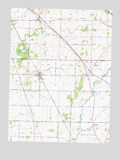
Morral, OH USGS Topographic Map
Click on map above to begin viewing in our Map Viewer.

This topographic map contains these locations and features:
Feature Name Type Latitude Longitude GNIS ID View Map
Ackley FarmsLocaleN40.6936°W83.1508°2652024View Map
Bretz CemeteryCemeteryN40.6980°W83.1452°1038286View Map
Brewer CemeteryCemeteryN40.6369°W83.1449°1960526View Map
Brush RidgePopulated PlaceN40.6876°W83.1535°1056734View Map
Carpenters CornersPopulated PlaceN40.6731°W83.2319°1060594View Map
Chapel Heights Memorial GardensCemeteryN40.6423°W83.1416°1960528View Map
Edwin Naus LakeReservoirN40.7208°W83.1590°1077726View Map
Edwin Naus Lake DamDamN40.7201°W83.1582°1077725View Map
Fetter and Son FarmsLocaleN40.6842°W83.1942°2652020View Map
Fitzhugh GraveCemeteryN40.6478°W83.1472°1960531View Map
Grand Prairie CemeteryCemeteryN40.6906°W83.1538°1041026View Map
Grand Prairie Elementary SchoolSchoolN40.6731°W83.1299°1049622View Map
Hickory Grove Golf CourseLocaleN40.7442°W83.2333°1055319View Map
Honey RunStreamN40.7317°W83.2127°1041739View Map
Kannel CemeteryCemeteryN40.6300°W83.2313°1960533View Map
Little SanduskyPopulated PlaceN40.7387°W83.2152°1065011View Map
Little Sandusky CemeteryCemeteryN40.7367°W83.2174°1730712View Map
Loudenslager AcresLocaleN40.6414°W83.2108°2652023View Map
MorralPopulated PlaceN40.6878°W83.2124°1065058View Map
Morral - Salt Rock Township Fire DepartmentBuildingN40.6869°W83.2139°2550039View Map
Morral Elementary SchoolSchoolN40.6873°W83.2105°1049621View Map
Morral Post OfficePost OfficeN40.6876°W83.2124°2035962View Map
Morral RunStreamN40.6853°W83.2280°1060635View Map
Neff CemeteryCemeteryN40.6859°W83.2219°1960538View Map
Ohio State Highway Patrol - Marion Patrol PostBuildingN40.6335°W83.1415°2733122View Map
Page CemeteryCemeteryN40.6470°W83.1709°1960539View Map
Pleasant Hill CemeteryCemeteryN40.6289°W83.2299°1044549View Map
Pleasant Hill Union Church (historical)ChurchN40.6295°W83.2271°1071765View Map
Richmond FarmsLocaleN40.7372°W83.1456°2652026View Map
Ridgedale High SchoolSchoolN40.6481°W83.1741°1081812View Map
Ridgedale Middle SchoolSchoolN40.6478°W83.1741°1071767View Map
Rock ForkStreamN40.6370°W83.1585°1066172View Map
Township of Grand PrairieCivilN40.6736°W83.1308°1086578View Map
Township of PittCivilN40.7495°W83.2441°1087209View Map
Township of Salt RockCivilN40.6731°W83.2467°1086585View Map
Village of MorralCivilN40.6914°W83.2098°2399395View Map

Note: Coordinates in the location and feature list above are referenced to NAD83 datum.


Copyright (C) 2008-2024 Ryan Niemi / Sunset Dynamics ... All Rights Reserved