TopoQuest Logo
Do you find TopoQuest useful?
Help keep TopoQuest running and adding new maps/features by donating!
Bitcoin:  19c7KJd3qBynnjoSw5npx9KScwjBe4ifkT
Litecoin:  LXs6TkuXGGXo1vDsWCkWVdjQX94eUKd6ui
Home View Maps Find Maps Find Places Resources & Links


Nevada, Ohio Topographic Map

USGS Map Title: Nevada, OH
USGS Map MRC: 40083G2
DRG (GeoTIFF) Download: o40083g2.tif


Neighboring USGS Topographic Map Quads:


  McCutchenville, OH  
40083H3
 

  Sycamore, OH  
40083H2
 

  Lykens, OH  
40083H1
 

  Upper Sandusky, OH  
40083G3
 

  Nevada, OH  
40083G2
 

  Oceola, OH  
40083G1
 

  Meeker, OH  
40083F3
 

  Morral, OH  
40083F2
 

  Monnett, OH  
40083F1


Map MRC Location:

N41°
W84°
N41°
W83°
H8 H7 H6 H5 H4 H3 H2 H1
G8 G7 G6 G5 G4 G3 G2 G1
F8 F7 F6 F5 F4 F3 F2 F1
E8 E7 E6 E5 E4 E3 E2 E1
D8 D7 D6 D5 D4 D3 D2 D1
C8 C7 C6 C5 C4 C3 C2 C1
B8 B7 B6 B5 B4 B3 B2 B1
A8 A7 A6 A5 A4 A3 A2 A1
N40°
W84°
N40°
W83°

Nevada, OH USGS 1:24K Topographic Map Preview:
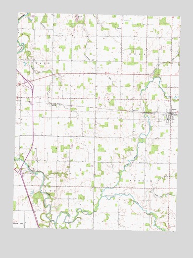
Nevada, OH USGS Topographic Map
Click on map above to begin viewing in our Map Viewer.

This topographic map contains these locations and features:
Feature Name Type Latitude Longitude GNIS ID View Map
Bethel ChurchChurchN40.8212°W83.2221°1060867View Map
Broken Sword CreekStreamN40.7695°W83.1821°1038339View Map
Burkes CemeteryCemeteryN40.7895°W83.1499°1038533View Map
Camp YoungLocaleN40.7787°W83.2249°1038773View Map
Douglass (historical)Populated PlaceN40.8226°W83.2224°1060691View Map
Eden Elementary SchoolSchoolN40.8676°W83.1707°1055337View Map
EdenvillePopulated PlaceN40.8198°W83.1596°1056269View Map
Emanuel CemeteryCemeteryN40.7895°W83.2074°1730705View Map
Emmanuel ChurchChurchN40.7895°W83.2069°1061058View Map
Gilliland CemeteryCemeteryN40.8313°W83.1797°1730707View Map
Grass RunStreamN40.7634°W83.1507°1041062View Map
Gray Eye RunStreamN40.7726°W83.1430°1041086View Map
Indian RunStreamN40.8364°W83.1474°1066045View Map
KJM FarmsLocaleN40.7844°W83.1297°2652025View Map
Lincoln Hill Golf CourseLocaleN40.8362°W83.2258°1073225View Map
Little Sandusky RiverStreamN40.7523°W83.2174°1057801View Map
McCarthy Stone QuarryMineN40.7853°W83.2369°2567610View Map
McClain CemeteryCemeteryN40.7847°W83.2419°1730715View Map
NevadaPopulated PlaceN40.8192°W83.1305°1056444View Map
Nevada CemeteryCemeteryN40.8342°W83.1327°1043809View Map
Nevada Lutheran ChurchChurchN40.8145°W83.1310°1073227View Map
Nevada Post OfficePost OfficeN40.8195°W83.1305°1958830View Map
Nevada United Methodist ChurchChurchN40.8206°W83.1310°1073228View Map
Oak Grove School (historical)SchoolN40.8617°W83.2230°1055336View Map
Old Rock Run CemeteryCemeteryN40.8259°W83.2288°1044126View Map
Pipetown Indian Number One CemeteryCemeteryN40.7578°W83.1880°1730722View Map
Pipetown Indian Number Two CemeteryCemeteryN40.7578°W83.1877°1730723View Map
Rock RunStreamN40.8545°W83.2444°1065889View Map
Rock Run CemeteryCemeteryN40.8217°W83.2224°1045119View Map
Salem CemeteryCemeteryN40.8409°W83.1924°1730728View Map
Salem ChurchChurchN40.8406°W83.1913°1045896View Map
Sandusky PlainsAreaN40.7506°W83.2485°1060695View Map
Smalley FarmLocaleN40.8047°W83.2292°2652027View Map
Swartz BridgeBridgeN40.7706°W83.1691°1055334View Map
Swartz CemeteryCemeteryN40.7728°W83.1688°1730732View Map
Township of AntrimCivilN40.7607°W83.1501°1087202View Map
Township of EdenCivilN40.8626°W83.1603°1087205View Map
Ulrich CemeteryCemeteryN40.8481°W83.1913°1047262View Map
Village of NevadaCivilN40.8188°W83.1312°2399447View Map
WVZX-FM (Upper Sandusky)TowerN40.8362°W83.2363°1083891View Map
Wyandot East Fire and Emergency Medical Services DistrictBuildingN40.8186°W83.1317°2550245View Map
Wyandot Indian CemeteryCemeteryN40.7675°W83.1618°1730738View Map
Wynford South Elementary SchoolSchoolN40.8151°W83.1335°1055335View Map

Note: Coordinates in the location and feature list above are referenced to NAD83 datum.


Copyright (C) 2008-2025 Ryan Niemi / Sunset Dynamics ... All Rights Reserved