TopoQuest Logo
Do you find TopoQuest useful?
Help keep TopoQuest running and adding new maps/features by donating!
Bitcoin:  19c7KJd3qBynnjoSw5npx9KScwjBe4ifkT
Litecoin:  LXs6TkuXGGXo1vDsWCkWVdjQX94eUKd6ui
Home View Maps Find Maps Find Places Resources & Links


Morrill, Maine Topographic Map

USGS Map Title: Morrill, ME
USGS Map MRC: 44069D2
DRG (GeoTIFF) Download: o44069d2.tif


Neighboring USGS Topographic Map Quads:


  Unity, ME  
44069E3
 

  Brooks West, ME  
44069E2
 

  Brooks East, ME  
44069E1
 

  Liberty, ME  
44069D3
 

  Morrill, ME  
44069D2
 

  Belfast, ME  
44069D1
 

  Washington, ME  
44069C3
 

  Searsmont, ME  
44069C2
 

  Lincolnville, ME  
44069C1


Map MRC Location:

N45°
W70°
N45°
W69°
H8 H7 H6 H5 H4 H3 H2 H1
G8 G7 G6 G5 G4 G3 G2 G1
F8 F7 F6 F5 F4 F3 F2 F1
E8 E7 E6 E5 E4 E3 E2 E1
D8 D7 D6 D5 D4 D3 D2 D1
C8 C7 C6 C5 C4 C3 C2 C1
B8 B7 B6 B5 B4 B3 B2 B1
A8 A7 A6 A5 A4 A3 A2 A1
N44°
W70°
N44°
W69°

Morrill, ME USGS 1:24K Topographic Map Preview:
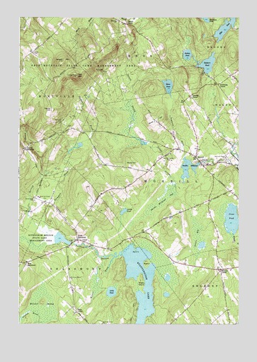
Morrill, ME USGS Topographic Map
Click on map above to begin viewing in our Map Viewer.

This topographic map contains these locations and features:
Feature Name Type Latitude Longitude GNIS ID View Map
Bartlett StreamStreamN44.4545°W69.2495°561678View Map
Bartlett Stream ReservoirReservoirN44.4097°W69.2259°1773990View Map
Belmont CornerPopulated PlaceN44.3973°W69.1356°562029View Map
Belmont SchoolSchoolN44.3751°W69.1314°562031View Map
Belmont Volunteer Fire DepartmentBuildingN44.3980°W69.1339°2552977View Map
Carter CemeteryCemeteryN44.4856°W69.2417°563639View Map
Center MontvillePopulated PlaceN44.4467°W69.2462°579186View Map
Cross PondLakeN44.4179°W69.1290°564573View Map
Dolliff PondLakeN44.4210°W69.1904°565195View Map
Dutton PondLakeN44.4803°W69.1431°565445View Map
East Knox SchoolSchoolN44.4987°W69.1939°565626View Map
Ellis PondReservoirN44.4955°W69.1332°565861View Map
Ellis Pond DamDamN44.4957°W69.1287°1773969View Map
Fosters CornerPopulated PlaceN44.4976°W69.1884°566465View Map
Frye MountainSummitN44.4762°W69.2172°566633View Map
Frye Mountain State Game Management AreaParkN44.4817°W69.2112°566634View Map
Gladys Weymouth Elementary SchoolSchoolN44.4424°W69.1469°2737921View Map
Green Wood CemeteryCemeteryN44.4259°W69.2414°567264View Map
Greers BogSwampN44.4104°W69.1484°567317View Map
Hillcrest CemeteryCemeteryN44.4084°W69.2132°568054View Map
Ironwood SchoolSchoolN44.4622°W69.2076°2738242View Map
Little PondLakeN44.3882°W69.1972°569974View Map
Merrill PointCapeN44.4051°W69.1839°571170View Map
Mixer PondLakeN44.4722°W69.1653°571480View Map
Morey HillSummitN44.4398°W69.1862°571660View Map
MorrillPopulated PlaceN44.4431°W69.1492°571672View Map
Morrill Post OfficePost OfficeN44.4470°W69.1483°2768942View Map
Morrill Volunteer Fire StationBuildingN44.4445°W69.1533°2552886View Map
North SearsmontPopulated PlaceN44.4090°W69.2164°572406View Map
Pauls CornerPopulated PlaceN44.3801°W69.2173°579606View Map
Pierce HillSummitN44.4621°W69.2313°573311View Map
Pierce Hill CemeteryCemeteryN44.4570°W69.2262°573313View Map
Poland StreamStreamN44.4334°W69.1567°573570View Map
Quantabacook LakeReservoirN44.3882°W69.1770°573930View Map
Rowe HillSummitN44.4587°W69.1691°574546View Map
Ruffingham Meadow State Game Management AreaParkN44.4079°W69.2392°574566View Map
Ruffingham Meadows DamDamN44.4080°W69.2201°1773989View Map
Sanborn PondReservoirN44.4772°W69.1429°574816View Map
Sanborn Pond DamDamN44.4772°W69.1429°1774476View Map
Sheep IslandIslandN44.3926°W69.1803°575347View Map
Simmons BrookStreamN44.4434°W69.1559°575472View Map
Smiths MillpondReservoirN44.4386°W69.1540°575648View Map
Smiths Millpond BogSwampN44.4248°W69.1687°575649View Map
Smiths Millpond DamDamN44.4406°W69.1468°1774478View Map
Spears MountainSummitN44.4806°W69.2253°575991View Map
Sunny Side CemeteryCemeteryN44.4782°W69.2019°576542View Map
Thompson BrookStreamN44.4129°W69.2312°576996View Map
Town of MorrillCivilN44.4343°W69.1662°582608View Map
West SearsmontPopulated PlaceN44.3998°W69.2456°579823View Map
Wilson BrookStreamN44.4023°W69.1959°578537View Map
Witcher SwampSwampN44.3809°W69.2417°578620View Map
Wood IslandIslandN44.4051°W69.1837°578650View Map

Note: Coordinates in the location and feature list above are referenced to NAD83 datum.


Copyright (C) 2008-2024 Ryan Niemi / Sunset Dynamics ... All Rights Reserved