TopoQuest Logo
Do you find TopoQuest useful?
Help keep TopoQuest running and adding new maps/features by donating!
Bitcoin:  19c7KJd3qBynnjoSw5npx9KScwjBe4ifkT
Litecoin:  LXs6TkuXGGXo1vDsWCkWVdjQX94eUKd6ui
Home View Maps Find Maps Find Places Resources & Links


Brooks West, Maine Topographic Map

USGS Map Title: Brooks West, ME
USGS Map MRC: 44069E2
DRG (GeoTIFF) Download: o44069e2.tif


Neighboring USGS Topographic Map Quads:


  Unity Pond, ME  
44069F3
 

  Dixmont, ME  
44069F2
 

  East Dixmont, ME  
44069F1
 

  Unity, ME  
44069E3
 

  Brooks West, ME  
44069E2
 

  Brooks East, ME  
44069E1
 

  Liberty, ME  
44069D3
 

  Morrill, ME  
44069D2
 

  Belfast, ME  
44069D1


Map MRC Location:

N45°
W70°
N45°
W69°
H8 H7 H6 H5 H4 H3 H2 H1
G8 G7 G6 G5 G4 G3 G2 G1
F8 F7 F6 F5 F4 F3 F2 F1
E8 E7 E6 E5 E4 E3 E2 E1
D8 D7 D6 D5 D4 D3 D2 D1
C8 C7 C6 C5 C4 C3 C2 C1
B8 B7 B6 B5 B4 B3 B2 B1
A8 A7 A6 A5 A4 A3 A2 A1
N44°
W70°
N44°
W69°

Brooks West, ME USGS 1:24K Topographic Map Preview:
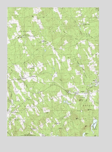
Brooks West, ME USGS Topographic Map
Click on map above to begin viewing in our Map Viewer.

This topographic map contains these locations and features:
Feature Name Type Latitude Longitude GNIS ID View Map
Aborn HillSummitN44.5229°W69.1973°561066View Map
Camp PaysockLocaleN44.5165°W69.1339°563410View Map
Cates CemeteryCemeteryN44.5762°W69.1673°563689View Map
Center ChurchChurchN44.5951°W69.2339°563748View Map
Cole CemeteryCemeteryN44.6145°W69.2025°564210View Map
East KnoxPopulated PlaceN44.5067°W69.2123°579273View Map
East Knox CemeteryCemeteryN44.5065°W69.2108°2725303View Map
East ThorndikePopulated PlaceN44.5917°W69.2012°579282View Map
East Thorndike CemeteryCemeteryN44.5973°W69.2295°565694View Map
Files HillSummitN44.6162°W69.2131°566149View Map
Halfmoon PondLakeN44.5009°W69.1447°567466View Map
Hedgehog HillSummitN44.5354°W69.1519°567889View Map
Jackson CornersLocaleN44.6087°W69.1442°568739View Map
Jackson Fire DepartmentBuildingN44.6007°W69.1434°2553089View Map
Knox CenterPopulated PlaceN44.5231°W69.2425°579460View Map
Knox Ledge CornerPopulated PlaceN44.5573°W69.2181°579463View Map
Knox StationLocaleN44.5553°W69.2306°569272View Map
Knox Station CemeteryCemeteryN44.5559°W69.2302°2737056View Map
Lake PassagassawakeagLakeN44.5114°W69.1313°573043View Map
Leonard CemeteryCemeteryN44.5367°W69.1892°569482View Map
Meadow BrookStreamN44.5490°W69.1398°571050View Map
Morse Memorial SchoolSchoolN44.5542°W69.1283°2738016View Map
Penny BrookStreamN44.5959°W69.1412°573170View Map
Pond HillSummitN44.5102°W69.1440°573597View Map
Ray CornerPopulated PlaceN44.5123°W69.1823°579648View Map
Skyscraper HillSummitN44.5259°W69.1408°575536View Map
Stantial BogSwampN44.5595°W69.1842°576248View Map
Stantial BrookStreamN44.5406°W69.1414°576249View Map
Styles CemeteryCemeteryN44.5799°W69.1281°576473View Map
Taggett HillSummitN44.5172°W69.1567°576639View Map
Town of JacksonCivilN44.6134°W69.1451°582533View Map
Town of KnoxCivilN44.5177°W69.2116°582545View Map
Town of ThorndikeCivilN44.5936°W69.2375°582764View Map
Walker CornerPopulated PlaceN44.5662°W69.2189°579795View Map
Wing BrookStreamN44.5645°W69.2487°578577View Map
Wing CemeteryCemeteryN44.5678°W69.2120°578579View Map

Note: Coordinates in the location and feature list above are referenced to NAD83 datum.


Copyright (C) 2008-2025 Ryan Niemi / Sunset Dynamics ... All Rights Reserved