TopoQuest Logo
Do you find TopoQuest useful?
Help keep TopoQuest running and adding new maps/features by donating!
Bitcoin:  19c7KJd3qBynnjoSw5npx9KScwjBe4ifkT
Litecoin:  LXs6TkuXGGXo1vDsWCkWVdjQX94eUKd6ui
Home View Maps Find Maps Find Places Resources & Links


Morro Hill, California Topographic Map

USGS Map Title: Morro Hill, CA
USGS Map MRC: 33117C3
DRG (GeoTIFF) Download: o33117c3.tif


Neighboring USGS Topographic Map Quads:


  Margarita Peak, CA  
33117D4
 

  Fallbrook, CA  
33117D3
 

  Temecula, CA  
33117D2
 

  Las Pulgas Canyon, CA  
33117C4
 

  Morro Hill, CA  
33117C3
 

  Bonsall, CA  
33117C2
 

  Oceanside, CA  
33117B4
 

  San Luis Rey, CA  
33117B3
 

  San Marcos, CA  
33117B2


Map MRC Location:

N34°
W118°
N34°
W117°
H8 H7 H6 H5 H4 H3 H2 H1
G8 G7 G6 G5 G4 G3 G2 G1
F8 F7 F6 F5 F4 F3 F2 F1
E8 E7 E6 E5 E4 E3 E2 E1
D8 D7 D6 D5 D4 D3 D2 D1
C8 C7 C6 C5 C4 C3 C2 C1
B8 B7 B6 B5 B4 B3 B2 B1
A8 A7 A6 A5 A4 A3 A2 A1
N33°
W118°
N33°
W117°

Morro Hill, CA USGS 1:24K Topographic Map Preview:
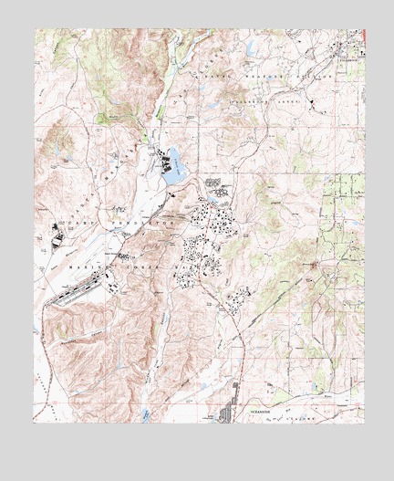
Morro Hill, CA USGS Topographic Map
Click on map above to begin viewing in our Map Viewer.

This topographic map contains these locations and features:
Feature Name Type Latitude Longitude GNIS ID View Map
Camp De LuzLocaleN33.3711°W117.3245°240084View Map
Camp Pendleton Fire Department Station 1BuildingN33.2994°W117.3469°2664744View Map
Camp Pendleton Fire Department Station 3BuildingN33.3122°W117.3106°2664747View Map
Camp Pendleton Fire Department Station 4BuildingN33.3297°W117.3273°2664746View Map
Camp Pendleton Fire Station 9BuildingN33.3687°W117.2634°2665305View Map
Camp Pendleton Marine Corps Air Station (Munn Field)AirportN33.3001°W117.3531°2650966View Map
Camp Pendleton North Census Designated PlaceCensusN33.3149°W117.3162°2407946View Map
ChappoPopulated PlaceN33.2931°W117.3620°252870View Map
Colony Plaza Shopping CenterLocaleN33.3675°W117.2523°1868368View Map
De Luz CreekStreamN33.3600°W117.3264°270775View Map
De Luz Station (historical)LocaleN33.3306°W117.3006°1703661View Map
Del Rio Elementary SchoolSchoolN33.2575°W117.2870°1868371View Map
DeLuzPopulated PlaceN33.3589°W117.2709°1660532View Map
Fallbrook Community AirparkAirportN33.3544°W117.2516°1653443View Map
Fallbrook Pioneer Odd Fellows CemeteryCemeteryN33.3683°W117.2574°1868408View Map
Fallbrook Towne Centre Shopping CenterLocaleN33.3723°W117.2523°1868389View Map
Foss Lake (historical)LakeN33.2575°W117.3175°1703667View Map
Home RanchLocaleN33.3098°W117.3417°243598View Map
Janssen Ranch (historical)LocaleN33.3217°W117.2600°1703668View Map
JofeganPopulated PlaceN33.3150°W117.3323°1660816View Map
KCEO-AM (Vista)TowerN33.2570°W117.2723°1662778View Map
Lake O'NeillReservoirN33.3296°W117.3228°246701View Map
Lake Oneill DamDamN33.3256°W117.3259°1664572View Map
Libby Elementary SchoolSchoolN33.2517°W117.3056°244776View Map
Libby Lake City ParkParkN33.2517°W117.3067°1868397View Map
Little Libby LakeLakeN33.2511°W117.3076°244925View Map
Marine Corps Air Station Camp PendletonMilitaryN33.3011°W117.3539°2512428View Map
Marine Memorial Golf CourseLocaleN33.2667°W117.3306°1868403View Map
Mary Fay Pendleton Elementary SchoolSchoolN33.3250°W117.3053°247368View Map
Morro HillSummitN33.3000°W117.2700°246228View Map
North County Fire Protection District Station 3BuildingN33.3166°W117.2500°2664868View Map
North River Road ParkParkN33.2561°W117.2873°1868405View Map
North River Road Park Community CenterBuildingN33.2561°W117.2878°1868406View Map
Oceanside Municipal Golf CourseLocaleN33.2589°W117.3195°1868407View Map
Pacifica Elementary SchoolSchoolN33.2567°W117.3036°1868409View Map
Pilgrim Creek DamDamN33.2767°W117.3042°1664574View Map
Pilgrim Creek LakeReservoirN33.2767°W117.3042°1664575View Map
Pueblitos CanyonValleyN33.2725°W117.3709°247812View Map
Ranch HouseLocaleN33.3034°W117.3445°247947View Map
Rancho Santa Margarita (historical)LocaleN33.3111°W117.3309°1703675View Map
Rattlesnake CanyonValleyN33.3153°W117.3292°247986View Map
Reynolds Elementary SchoolSchoolN33.2586°W117.3095°1868417View Map
Windmill LakeReservoirN33.2524°W117.3332°251714View Map
Wood CanyonValleyN33.3411°W117.3342°251763View Map
Ysidora (historical)Populated PlaceN33.2598°W117.3636°1703678View Map
Ysidora BasinBasinN33.2581°W117.3703°251882View Map

Note: Coordinates in the location and feature list above are referenced to NAD83 datum.


Copyright (C) 2008-2024 Ryan Niemi / Sunset Dynamics ... All Rights Reserved