TopoQuest Logo
Do you find TopoQuest useful?
Help keep TopoQuest running and adding new maps/features by donating!
Bitcoin:  19c7KJd3qBynnjoSw5npx9KScwjBe4ifkT
Litecoin:  LXs6TkuXGGXo1vDsWCkWVdjQX94eUKd6ui
Home View Maps Find Maps Find Places Resources & Links


Mosquero, New Mexico Topographic Map

USGS Map Title: Mosquero, NM
USGS Map MRC: 35103G8
DRG (GeoTIFF) Download: o35103g8.tif


Neighboring USGS Topographic Map Quads:


  Kansas Valley Lake, NM  
35104H1
 

  Sabino, NM  
35103H8
 

  Albert, NM  
35103H7
 

  Solano, NM  
35104G1
 

  Mosquero, NM  
35103G8
 

  Arroyo Del Alamo, NM  
35103G7
 

  Waggoner Ranch, NM  
35104F1
 

  Chinaberry Canyon, NM  
35103F8
 

  Salitre Canyon, NM  
35103F7


Map MRC Location:

N36°
W104°
N36°
W103°
H8 H7 H6 H5 H4 H3 H2 H1
G8 G7 G6 G5 G4 G3 G2 G1
F8 F7 F6 F5 F4 F3 F2 F1
E8 E7 E6 E5 E4 E3 E2 E1
D8 D7 D6 D5 D4 D3 D2 D1
C8 C7 C6 C5 C4 C3 C2 C1
B8 B7 B6 B5 B4 B3 B2 B1
A8 A7 A6 A5 A4 A3 A2 A1
N35°
W104°
N35°
W103°

Mosquero, NM USGS 1:24K Topographic Map Preview:
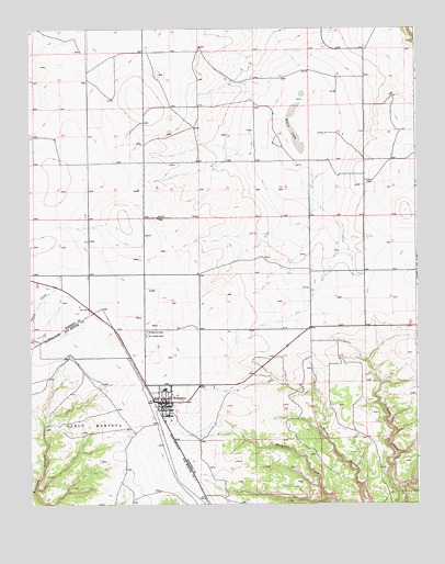
Mosquero, NM USGS Topographic Map
Click on map above to begin viewing in our Map Viewer.

This topographic map contains these locations and features:
Feature Name Type Latitude Longitude GNIS ID View Map
Black LakeFlatN35.8484°W103.9152°886419View Map
GaleyLocaleN35.8270°W103.9814°924350View Map
Goodnight-Loving Trail Historical MarkerParkN35.7770°W103.9566°932358View Map
Harding County CourthouseBuildingN35.7770°W103.9566°933599View Map
Harding County Sheriff's OfficeBuildingN35.7752°W103.9573°2722555View Map
McDanielsLocaleN35.8128°W103.9075°924278View Map
MosqueroPopulated PlaceN35.7770°W103.9566°892254View Map
Mosquero CemeteryCemeteryN35.7956°W103.9627°892256View Map
Mosquero Elementary SchoolSchoolN35.7806°W103.9572°933895View Map
Mosquero High SchoolSchoolN35.7806°W103.9572°901365View Map
Mosquero Post OfficePost OfficeN35.7768°W103.9573°2781350View Map
Mosquero Post Office (historical)Post OfficeN35.7798°W103.9566°938204View Map
Mosquero Village Police DepartmentBuildingN35.7752°W103.9572°2722525View Map
Mosquero Volunteer Fire DepartmentBuildingN35.7768°W103.9565°2657666View Map
Mosquero Weather StationLocaleN35.7770°W103.9566°932575View Map
Saint Joseph CemeteryCemeteryN35.7945°W103.9627°894274View Map
TrujilloLocaleN35.8350°W103.8883°924325View Map
Village of MosqueroCivilN35.7743°W103.9544°2413574View Map
WagoneerLocaleN35.7870°W103.9864°924308View Map

Note: Coordinates in the location and feature list above are referenced to NAD83 datum.


Copyright (C) 2008-2025 Ryan Niemi / Sunset Dynamics ... All Rights Reserved