TopoQuest Logo
Do you find TopoQuest useful?
Help keep TopoQuest running and adding new maps/features by donating!
Bitcoin:  19c7KJd3qBynnjoSw5npx9KScwjBe4ifkT
Litecoin:  LXs6TkuXGGXo1vDsWCkWVdjQX94eUKd6ui
Home View Maps Find Maps Find Places Resources & Links


Chinaberry Canyon, New Mexico Topographic Map

USGS Map Title: Chinaberry Canyon, NM
USGS Map MRC: 35103F8
DRG (GeoTIFF) Download: o35103f8.tif


Neighboring USGS Topographic Map Quads:


  Solano, NM  
35104G1
 

  Mosquero, NM  
35103G8
 

  Arroyo Del Alamo, NM  
35103G7
 

  Waggoner Ranch, NM  
35104F1
 

  Chinaberry Canyon, NM  
35103F8
 

  Salitre Canyon, NM  
35103F7
 

  Bell Ranch, NM  
35104E1
 

  Campana, NM  
35103E8
 

  Alamosa Canyon, NM  
35103E7


Map MRC Location:

N36°
W104°
N36°
W103°
H8 H7 H6 H5 H4 H3 H2 H1
G8 G7 G6 G5 G4 G3 G2 G1
F8 F7 F6 F5 F4 F3 F2 F1
E8 E7 E6 E5 E4 E3 E2 E1
D8 D7 D6 D5 D4 D3 D2 D1
C8 C7 C6 C5 C4 C3 C2 C1
B8 B7 B6 B5 B4 B3 B2 B1
A8 A7 A6 A5 A4 A3 A2 A1
N35°
W104°
N35°
W103°

Chinaberry Canyon, NM USGS 1:24K Topographic Map Preview:
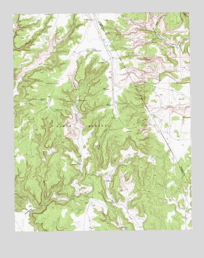
Chinaberry Canyon, NM USGS Topographic Map
Click on map above to begin viewing in our Map Viewer.

This topographic map contains these locations and features:
Feature Name Type Latitude Longitude GNIS ID View Map
Antelope CanyonValleyN35.7300°W103.9991°885769View Map
Antelope TankReservoirN35.7496°W103.9723°885798View Map
CabezaLocaleN35.7134°W103.9316°887045View Map
Chinaberry CanyonValleyN35.6420°W103.9789°887550View Map
Cimaron TankReservoirN35.6947°W103.9712°887605View Map
Dry Mule TankReservoirN35.7007°W103.9821°888540View Map
Fragoso CanyonValleyN35.7306°W103.8830°889209View Map
Juarez WindmillLocaleN35.6373°W103.9914°890592View Map
Lower Cabeza TankReservoirN35.6976°W103.9348°891419View Map
Lower Medio WindmillLocaleN35.6267°W103.9258°891438View Map
Lower Rattlesnake TankReservoirN35.6634°W103.9535°891448View Map
Lower Rattlesnake WindmillLocaleN35.7003°W103.9558°891449View Map
MedioLocaleN35.6409°W103.9477°891826View Map
Mitchel WindmillLocaleN35.7464°W103.9452°892122View Map
Orchard CanyonValleyN35.7412°W103.8997°892927View Map
Polita Number TwoMineN35.7356°W103.8769°914989View Map
Turkey TankReservoirN35.7100°W103.9725°895915View Map
Upper Cabeza TankReservoirN35.7065°W103.9371°896011View Map
Upper Medio WindmillLocaleN35.6537°W103.9355°896030View Map
Upper Rattlesnake TankReservoirN35.7288°W103.9441°896036View Map
Upper Rattlesnake WindmillLocaleN35.7228°W103.9344°896037View Map

Note: Coordinates in the location and feature list above are referenced to NAD83 datum.


Copyright (C) 2008-2025 Ryan Niemi / Sunset Dynamics ... All Rights Reserved