TopoQuest Logo
Do you find TopoQuest useful?
Help keep TopoQuest running and adding new maps/features by donating!
Bitcoin:  19c7KJd3qBynnjoSw5npx9KScwjBe4ifkT
Litecoin:  LXs6TkuXGGXo1vDsWCkWVdjQX94eUKd6ui
Home View Maps Find Maps Find Places Resources & Links


Moss Back Butte, Utah Topographic Map

USGS Map Title: Moss Back Butte, UT
USGS Map MRC: 37110E1
DRG (GeoTIFF) Download: o37110e1.tif


Neighboring USGS Topographic Map Quads:


  Jacobs Chair, UT  
37110F2
 

  The Cheesebox, UT  
37110F1
 

  Woodenshoe Buttes, UT  
37109F8
 

  Fry Spring, UT  
37110E2
 

  Moss Back Butte, UT  
37110E1
 

  Kane Gulch, UT  
37109E8
 

  Red House Spring, UT  
37110D2
 

  Pollys Pasture, UT  
37110D1
 

  Cedar Mesa North, UT  
37109D8


Map MRC Location:

N38°
W111°
N38°
W110°
H8 H7 H6 H5 H4 H3 H2 H1
G8 G7 G6 G5 G4 G3 G2 G1
F8 F7 F6 F5 F4 F3 F2 F1
E8 E7 E6 E5 E4 E3 E2 E1
D8 D7 D6 D5 D4 D3 D2 D1
C8 C7 C6 C5 C4 C3 C2 C1
B8 B7 B6 B5 B4 B3 B2 B1
A8 A7 A6 A5 A4 A3 A2 A1
N37°
W111°
N37°
W110°

Moss Back Butte, UT USGS 1:24K Topographic Map Preview:
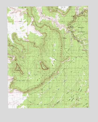
Moss Back Butte, UT USGS Topographic Map
Click on map above to begin viewing in our Map Viewer.

This topographic map contains these locations and features:
Feature Name Type Latitude Longitude GNIS ID View Map
Armstrong CanyonValleyN37.5998°W110.0309°1438270View Map
Atomic RockPillarN37.5855°W110.0390°1435073View Map
Bridge ViewLocaleN37.5822°W110.0146°1435190View Map
Bridge ViewLocaleN37.5980°W110.0271°1435191View Map
Bridge ViewLocaleN37.6169°W110.0001°1448179View Map
Cathedral RockPillarN37.6089°W110.0229°1426411View Map
Cow TankValleyN37.5020°W110.0595°1427011View Map
Deer CanyonValleyN37.6142°W110.0188°1427300View Map
Dripping PointRidgeN37.5314°W110.0058°1427485View Map
Fry MesaSummitN37.6225°W110.0928°1450361View Map
Horse Collar RuinLocaleN37.6128°W110.0215°1435703View Map
Indian FootArchN37.5972°W110.0346°1441998View Map
Kachina BridgeArchN37.6001°W110.0310°1455883View Map
Moss BackSummitN37.5319°W110.0968°1430513View Map
Moss Back ButteSummitN37.5489°W110.0660°1455408View Map
Natural Bridges National MonumentParkN37.6045°W110.0022°1454484View Map
Natural Bridges National Monument Picnic AreaParkN37.6100°W110.0035°1436025View Map
Owachomo BridgeArchN37.5814°W110.0149°1455898View Map
Ruin RockPillarN37.6025°W110.0296°1432050View Map
Sipapu BridgeArchN37.6250°W110.0174°1432493View Map
Tables of the SunSummitN37.5430°W110.1034°1437454View Map
The NeedleSummitN37.6067°W110.1076°1433381View Map
The ShoeArchN37.5861°W110.0171°1433425View Map
The WindgateSummitN37.5430°W110.1034°1433452View Map
To-ko-chi CanyonValleyN37.5914°W110.0256°1433556View Map
Tuwa CanyonValleyN37.5816°W110.0130°1446771View Map

Note: Coordinates in the location and feature list above are referenced to NAD83 datum.


Copyright (C) 2008-2025 Ryan Niemi / Sunset Dynamics ... All Rights Reserved