TopoQuest Logo
Do you find TopoQuest useful?
Help keep TopoQuest running and adding new maps/features by donating!
Bitcoin:  19c7KJd3qBynnjoSw5npx9KScwjBe4ifkT
Litecoin:  LXs6TkuXGGXo1vDsWCkWVdjQX94eUKd6ui
Home View Maps Find Maps Find Places Resources & Links


Pollys Pasture, Utah Topographic Map

USGS Map Title: Pollys Pasture, UT
USGS Map MRC: 37110D1
DRG (GeoTIFF) Download: o37110d1.tif


Neighboring USGS Topographic Map Quads:


  Fry Spring, UT  
37110E2
 

  Moss Back Butte, UT  
37110E1
 

  Kane Gulch, UT  
37109E8
 

  Red House Spring, UT  
37110D2
 

  Pollys Pasture, UT  
37110D1
 

  Cedar Mesa North, UT  
37109D8
 

  Slickhorn Canyon West, UT  
37110C2
 

  Slickhorn Canyon East, UT  
37110C1
 

  Cedar Mesa South, UT  
37109C8


Map MRC Location:

N38°
W111°
N38°
W110°
H8 H7 H6 H5 H4 H3 H2 H1
G8 G7 G6 G5 G4 G3 G2 G1
F8 F7 F6 F5 F4 F3 F2 F1
E8 E7 E6 E5 E4 E3 E2 E1
D8 D7 D6 D5 D4 D3 D2 D1
C8 C7 C6 C5 C4 C3 C2 C1
B8 B7 B6 B5 B4 B3 B2 B1
A8 A7 A6 A5 A4 A3 A2 A1
N37°
W111°
N37°
W110°

Pollys Pasture, UT USGS 1:24K Topographic Map Preview:
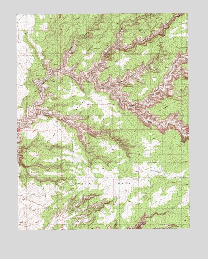
Pollys Pasture, UT USGS Topographic Map
Click on map above to begin viewing in our Map Viewer.

This topographic map contains these locations and features:
Feature Name Type Latitude Longitude GNIS ID View Map
Big Man PanelCliffN37.4550°W110.1062°1435128View Map
Big RuinLocaleN37.4622°W110.1124°1435131View Map
Bullet CanyonValleyN37.4447°W110.0415°1426148View Map
Bullet Canyon SpringSpringN37.4450°W110.0424°1435215View Map
Cow Trail CanyonValleyN37.4650°W110.1024°1435364View Map
Coyote CanyonValleyN37.4639°W110.0140°1435367View Map
Coyote SpringSpringN37.4644°W110.0074°1435369View Map
Deer Canyon SpringSpringN37.4158°W110.1240°1435397View Map
Dripping CanyonValleyN37.4682°W110.0934°1427484View Map
Government TrailTrailN37.4394°W110.1129°1435600View Map
Grand Gulch Primitive AreaParkN37.4583°W110.0840°1455299View Map
Green Canyon SpringSpringN37.4589°W110.0540°1435619View Map
Green Mash SpringSpringN37.4533°W110.0218°1435620View Map
HardscrabbleFlatN37.4078°W110.0232°1428526View Map
Jailhouse RuinLocaleN37.4383°W110.0112°1435765View Map
Jailhouse SpringSpringN37.4372°W110.0151°1435766View Map
Pine CanyonValleyN37.4806°W110.0530°1444362View Map
Pollys CanyonValleyN37.4461°W110.1179°1436152View Map
Pollys IslandIslandN37.4422°W110.1162°1436153View Map
Pollys PastureFlatN37.4328°W110.1121°1431393View Map
Pollys SpringSpringN37.4428°W110.1096°1436155View Map
Red House CliffsCliffN37.4167°W110.0312°1455151View Map
Sheiks CanyonValleyN37.4522°W110.0251°1436342View Map
Steer GulchValleyN37.4644°W110.1029°1432949View Map
Step CanyonValleyN37.4651°W110.0719°1446130View Map
Step PointRidgeN37.4936°W110.0226°1446132View Map
Step SpringSpringN37.4706°W110.0668°1436435View Map
The Thumb Pour OffFallsN37.4572°W110.0201°1436493View Map

Note: Coordinates in the location and feature list above are referenced to NAD83 datum.


Copyright (C) 2008-2025 Ryan Niemi / Sunset Dynamics ... All Rights Reserved