TopoQuest Logo
Do you find TopoQuest useful?
Help keep TopoQuest running and adding new maps/features by donating!
Bitcoin:  19c7KJd3qBynnjoSw5npx9KScwjBe4ifkT
Litecoin:  LXs6TkuXGGXo1vDsWCkWVdjQX94eUKd6ui
Home View Maps Find Maps Find Places Resources & Links


Moss Landing, California Topographic Map

USGS Map Title: Moss Landing, CA
USGS Map MRC: 36121G7
DRG (GeoTIFF) Download: o36121g7.tif


Neighboring USGS Topographic Map Quads:


  Soquel, CA  
36121H8
 

  Watsonville West, CA  
36121H7
 

  Watsonville East, CA  
36121H6


  Moss Landing, CA  
36121G7
 

  Prunedale, CA  
36121G6


  Marina, CA  
36121F7
 

  Salinas, CA  
36121F6


Map MRC Location:

N37°
W122°
N37°
W121°
H8 H7 H6 H5 H4 H3 H2 H1
G8 G7 G6 G5 G4 G3 G2 G1
F8 F7 F6 F5 F4 F3 F2 F1
E8 E7 E6 E5 E4 E3 E2 E1
D8 D7 D6 D5 D4 D3 D2 D1
C8 C7 C6 C5 C4 C3 C2 C1
B8 B7 B6 B5 B4 B3 B2 B1
A8 A7 A6 A5 A4 A3 A2 A1
N36°
W122°
N36°
W121°

Moss Landing, CA USGS 1:24K Topographic Map Preview:
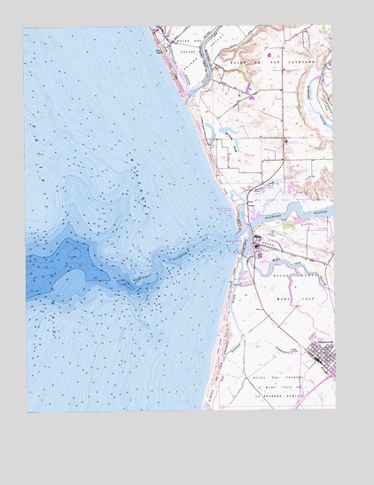
Moss Landing, CA USGS Topographic Map
Click on map above to begin viewing in our Map Viewer.

This topographic map contains these locations and features:
Feature Name Type Latitude Longitude GNIS ID View Map
Bennett SloughGutN36.8227°W121.7786°219047View Map
Bolsa De San CayetanoCivilN36.8666°W121.7722°219614View Map
Bolsa Del Potrero Y Moro Cojo or La Sagrada FamiliaCivilN36.7516°W121.7699°219616View Map
Camp Goodall (historical)LocaleN36.8672°W121.8183°1670523View Map
CastrovillePopulated PlaceN36.7658°W121.7580°277486View Map
Castroville Branch Monterey County Free LibrariesBuildingN36.7627°W121.7544°1873150View Map
Castroville Census Designated PlaceCensusN36.7648°W121.7534°2407988View Map
Castroville Community CenterBuildingN36.7675°W121.7552°1873151View Map
Castroville DivisionCivilN36.7747°W121.8249°1935044View Map
Castroville Elementary SchoolSchoolN36.7636°W121.7535°1873152View Map
Castroville Justice LibraryBuildingN36.7661°W121.7588°1873153View Map
Castroville Moss Landing CemeteryCemeteryN36.7935°W121.7853°220713View Map
Castroville Post OfficePost OfficeN36.7655°W121.7574°1873154View Map
Castroville Station Shopping CenterLocaleN36.7619°W121.7536°1873155View Map
City Lands of MontereyCivilN36.8011°W121.7888°221131View Map
Elkhorn SloughStreamN36.8058°W121.7902°223143View Map
Elkhorn Yacht CLubLocaleN36.8136°W121.7869°253319View Map
Entrance ChannelCanalN36.8075°W121.7883°253348View Map
Inner ChannelCanalN36.8041°W121.7855°253349View Map
Island BeachBeachN36.8047°W121.7880°1703613View Map
Jetty BeachBeachN36.8097°W121.7900°1703614View Map
KDON-AM (Salinas)TowerN36.8697°W121.8191°1664937View Map
KLAU-AM (Capitola)TowerN36.8688°W121.7841°1664854View Map
KOQI-AM (Soquel)TowerN36.8647°W121.7922°1664977View Map
McClusky SloughLakeN36.8358°W121.7896°228310View Map
Monterey Bay Salt WorksMineN36.8183°W121.7786°2680943View Map
Monterey CanyonValleyN36.7833°W121.8344°228963View Map
Moro Cojo SloughStreamN36.8025°W121.7847°229070View Map
MossPopulated PlaceN36.7986°W121.7861°1670518View Map
Moss LandingPopulated PlaceN36.8044°W121.7869°1659184View Map
Moss Landing Census Designated PlaceCensusN36.8015°W121.7872°2408874View Map
Moss Landing HarborHarborN36.8038°W121.7891°253350View Map
Moss Landing Harbor District OfficeBuildingN36.7994°W121.7861°1873159View Map
Moss Landing Marine LaboratoriesLocaleN36.8002°W121.7891°1703617View Map
Moss Landing Middle SchoolSchoolN36.8372°W121.7700°229123View Map
Moss Landing Post OfficePost OfficeN36.7979°W121.7863°1873160View Map
Moss Landing Power PlantBuildingN36.8061°W121.7816°1703618View Map
Moss Landing State BeachParkN36.8136°W121.7905°1703619View Map
Moss Landing State Wildlife AreaParkN36.8180°W121.7702°1703620View Map
North County Fire Protection District of Monterey County Station 1BuildingN36.7681°W121.7572°2624150View Map
North Monterey County Middle SchoolSchoolN36.7718°W121.7577°1873158View Map
Northern Monterey County School District OfficeBuildingN36.7966°W121.7863°1873161View Map
Ohlone Elementary SchoolSchoolN36.8700°W121.7620°2504418View Map
Old Salinas RiverGutN36.7738°W121.7880°229984View Map
Pajaro DivisionCivilN36.8424°W121.7872°1935237View Map
Pajaro Dunes Census Designated PlaceCensusN36.8722°W121.8101°2583104View Map
Pajaro RiverStreamN36.8500°W121.8097°230242View Map
Pajaro River Mouth Natural PreserveReserveN36.8483°W121.8074°2741290View Map
Pajaro ValleyValleyN36.8605°W121.8086°230243View Map
Palm Beach (historical)LocaleN36.8672°W121.8180°230258View Map
Pauls IslandIslandN36.8169°W121.7841°230421View Map
Port Watsonville (historical)Populated PlaceN36.8747°W121.8250°1670531View Map
Salinas River Dunes Natural PreserveReserveN36.7802°W121.7947°2741317View Map
Salinas River Mouth Natural PreserveReserveN36.7530°W121.8032°2741321View Map
Salinas River State BeachParkN36.7830°W121.7955°1703621View Map
Sandholdt PierLocaleN36.8011°W121.7900°1703623View Map
Sandholt BridgeBridgeN36.8000°W121.7877°1703622View Map
Springfield School (historical)SchoolN36.8383°W121.7708°1670519View Map
Tembladero SloughStreamN36.7733°W121.7886°253967View Map
Watsonville Golf CourseLocaleN36.8725°W121.7527°1654508View Map
Watsonville SloughStreamN36.8533°W121.8088°237354View Map
Zmudowski State BeachParkN36.8372°W121.8025°238324View Map

Note: Coordinates in the location and feature list above are referenced to NAD83 datum.


Copyright (C) 2008-2025 Ryan Niemi / Sunset Dynamics ... All Rights Reserved