TopoQuest Logo
Do you find TopoQuest useful?
Help keep TopoQuest running and adding new maps/features by donating!
Bitcoin:  19c7KJd3qBynnjoSw5npx9KScwjBe4ifkT
Litecoin:  LXs6TkuXGGXo1vDsWCkWVdjQX94eUKd6ui
Home View Maps Find Maps Find Places Resources & Links


Prunedale, California Topographic Map

USGS Map Title: Prunedale, CA
USGS Map MRC: 36121G6
DRG (GeoTIFF) Download: o36121g6.tif


Neighboring USGS Topographic Map Quads:


  Watsonville West, CA  
36121H7
 

  Watsonville East, CA  
36121H6
 

  Chittenden, CA  
36121H5
 

  Moss Landing, CA  
36121G7
 

  Prunedale, CA  
36121G6
 

  San Juan Bautista, CA  
36121G5
 

  Marina, CA  
36121F7
 

  Salinas, CA  
36121F6
 

  Natividad, CA  
36121F5


Map MRC Location:

N37°
W122°
N37°
W121°
H8 H7 H6 H5 H4 H3 H2 H1
G8 G7 G6 G5 G4 G3 G2 G1
F8 F7 F6 F5 F4 F3 F2 F1
E8 E7 E6 E5 E4 E3 E2 E1
D8 D7 D6 D5 D4 D3 D2 D1
C8 C7 C6 C5 C4 C3 C2 C1
B8 B7 B6 B5 B4 B3 B2 B1
A8 A7 A6 A5 A4 A3 A2 A1
N36°
W122°
N36°
W121°

Prunedale, CA USGS 1:24K Topographic Map Preview:
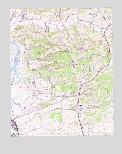
Prunedale, CA USGS Topographic Map
Click on map above to begin viewing in our Map Viewer.

This topographic map contains these locations and features:
Feature Name Type Latitude Longitude GNIS ID View Map
American Medical Response Ambulance Service PrunedaleBuildingN36.7907°W121.6686°2662265View Map
Berta CanyonValleyN36.7858°W121.6674°219090View Map
Bolsa Nueva Y Moro CojoCivilN36.8066°W121.6886°219617View Map
Caņada de la CarpenteriaCivilN36.8541°W121.6436°240137View Map
Carneros CreekStreamN36.8591°W121.7470°2729389View Map
Central Bay Continuation High SchoolSchoolN36.7755°W121.6686°2504412View Map
Central Bay Continuation High SchoolSchoolN36.7777°W121.7344°1873168View Map
Del Monte JunctionLocaleN36.7580°W121.7438°1670482View Map
Dunbarton (historical)Populated PlaceN36.8583°W121.6469°1670483View Map
Echo ValleyValleyN36.8208°W121.6716°222961View Map
Echo Valley Elementary SchoolSchoolN36.8261°W121.6663°1873169View Map
El Camino Continuation High SchoolSchoolN36.7752°W121.6688°1873170View Map
ElkhornPopulated PlaceN36.8244°W121.7405°277507View Map
Elkhorn Census Designated PlaceCensusN36.8103°W121.7211°2408075View Map
Elkhorn Elementary SchoolSchoolN36.7969°W121.7189°1873171View Map
Elkhorn School (historical)SchoolN36.8000°W121.6980°1670484View Map
Elkhorn Slough National Estuarine Research ReserveParkN36.8197°W121.7383°1873172View Map
Hall Elementary SchoolSchoolN36.8653°W121.7234°2504493View Map
Hambey CemeteryCemeteryN36.8374°W121.6810°224827View Map
Hidden Oak Picnic AreaLocaleN36.8425°W121.6683°1873181View Map
Kirby ParkParkN36.8419°W121.7441°1873183View Map
KPIG-FM (Freedom)TowerN36.8350°W121.7072°1665031View Map
Lake School (historical)SchoolN36.8305°W121.6794°1670485View Map
Langley CanyonValleyN36.8044°W121.6666°226857View Map
Langley School (historical)SchoolN36.8147°W121.6413°1670486View Map
Las LomasPopulated PlaceN36.8652°W121.7349°1655082View Map
Las Lomas Census Designated PlaceCensusN36.8688°W121.7316°2408578View Map
Liberty Family Academy (historical)SchoolN36.8008°W121.6657°2504489View Map
Live Oak Picnic AreaLocaleN36.8416°W121.6683°1873184View Map
Long CanyonValleyN36.8080°W121.7369°227541View Map
Los CarnerosCivilN36.8550°W121.7083°234197View Map
Manzanita County ParkParkN36.7972°W121.6819°1873186View Map
Merritt LakeFlatN36.7552°W121.6986°228531View Map
North County Fire Protection District of Monterey County Station 2BuildingN36.7765°W121.6670°2624040View Map
North County Fire Protection District of Monterey County Station 3BuildingN36.8676°W121.7443°2624041View Map
North Monterey County Adult SchoolSchoolN36.7780°W121.7344°1873189View Map
North Monterey County Center for Independent StudySchoolN36.7777°W121.7345°1873191View Map
North Monterey County High SchoolSchoolN36.7777°W121.7345°1873190View Map
Oak HillsPopulated PlaceN36.7777°W121.7161°1873192View Map
Paradise CanyonValleyN36.7863°W121.7480°1670487View Map
Paradise ValleyValleyN36.8036°W121.7036°230328View Map
Parsons SloughStreamN36.8161°W121.7456°2710189View Map
Peoples ParkParkN36.7672°W121.7491°1873193View Map
Pesante CanyonValleyN36.7713°W121.6663°230546View Map
Pine Grove Youth CampLocaleN36.8402°W121.6663°1873195View Map
PrunedalePopulated PlaceN36.7758°W121.6697°277580View Map
Prunedale Branch Monterey County Free LibrariesBuildingN36.8022°W121.6655°1873196View Map
Prunedale Census Designated PlaceCensusN36.8064°W121.6555°2409105View Map
Prunedale Christian AcademySchoolN36.7991°W121.6654°1873197View Map
Prunedale Christian SchoolSchoolN36.7913°W121.6691°1873198View Map
Prunedale Elementary SchoolSchoolN36.7784°W121.6663°1873199View Map
Prunedale School (historical)SchoolN36.7880°W121.6711°1670488View Map
Prunedale Shopping CenterLocaleN36.8019°W121.6655°1873200View Map
Queen of Heaven CemeteryCemeteryN36.7604°W121.6610°1873201View Map
Royal Oaks County ParkParkN36.8405°W121.6658°1873202View Map
San Miguel CanyonValleyN36.7663°W121.6711°232451View Map
Schneider HillSummitN36.7600°W121.6616°232657View Map
Strawberry CanyonValleyN36.8297°W121.7349°235580View Map
Swiss CanyonValleyN36.8300°W121.7316°235910View Map
Vierra CanyonValleyN36.7922°W121.6677°237079View Map
Westmed Ambulance Unit 30BuildingN36.8633°W121.7355°2662144View Map

Note: Coordinates in the location and feature list above are referenced to NAD83 datum.


Copyright (C) 2008-2025 Ryan Niemi / Sunset Dynamics ... All Rights Reserved