TopoQuest Logo
Do you find TopoQuest useful?
Help keep TopoQuest running and adding new maps/features by donating!
Bitcoin:  19c7KJd3qBynnjoSw5npx9KScwjBe4ifkT
Litecoin:  LXs6TkuXGGXo1vDsWCkWVdjQX94eUKd6ui
Home View Maps Find Maps Find Places Resources & Links


Beech Hill, West Virginia Topographic Map

USGS Map Title: Beech Hill, WV
USGS Map MRC: 38082G1
DRG (GeoTIFF) Download: o38082g1.tif


Neighboring USGS Topographic Map Quads:


  Addison, OH  
38082H2
 

  Cheshire, OH  
38082H1
 

  New Haven, WV  
38081H8
 

  Gallipolis, OH  
38082G2
 

  Beech Hill, WV  
38082G1
 

  Mount Alto, WV  
38081G8
 

  Apple Grove, WV  
38082F2
 

  Arlee, WV  
38082F1
 

  Robertsburg, WV  
38081F8


Map MRC Location:

N39°
W83°
N39°
W82°
H8 H7 H6 H5 H4 H3 H2 H1
G8 G7 G6 G5 G4 G3 G2 G1
F8 F7 F6 F5 F4 F3 F2 F1
E8 E7 E6 E5 E4 E3 E2 E1
D8 D7 D6 D5 D4 D3 D2 D1
C8 C7 C6 C5 C4 C3 C2 C1
B8 B7 B6 B5 B4 B3 B2 B1
A8 A7 A6 A5 A4 A3 A2 A1
N38°
W83°
N38°
W82°

Beech Hill, WV USGS 1:24K Topographic Map Preview:
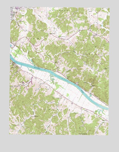
Beech Hill, WV USGS Topographic Map
Click on map above to begin viewing in our Map Viewer.

This topographic map contains these locations and features:
Feature Name Type Latitude Longitude GNIS ID View Map
AmbrosiaPopulated PlaceN38.8056°W82.0526°1553725View Map
Arbuckle CreekStreamN38.8242°W82.1243°1550111View Map
Beech HillPopulated PlaceN38.7648°W82.0026°1535541View Map
Beech Hill CemeteryCemeteryN38.7673°W82.0115°1678887View Map
Beech Hill School (historical)SchoolN38.7670°W82.0060°1560133View Map
Blain SpringSpringN38.7645°W82.1054°1560140View Map
BrightonPopulated PlaceN38.7998°W82.0404°1549611View Map
Brighton CemeteryCemeteryN38.8006°W82.0399°1678889View Map
Brighton Methodist Episcopal ChurchChurchN38.8004°W82.0401°1678890View Map
Clarence Casto SpringSpringN38.8134°W82.1143°1560156View Map
College Hill ChurchChurchN38.7679°W82.0940°1537520View Map
Concord CemeteryCemeteryN38.7870°W82.0604°1678893View Map
Concord ChurchChurchN38.7867°W82.0604°1537563View Map
CouchPopulated PlaceN38.7887°W82.0588°1549644View Map
Dale Neibert SpringSpringN38.8006°W82.0835°1560167View Map
Dawley SpringSpringN38.7890°W82.0615°1560168View Map
Duff SpringSpringN38.8201°W82.0126°1560174View Map
Ecard ChurchChurchN38.8517°W82.0382°1538539View Map
Eddy ChapelChurchN38.8148°W82.0054°1538545View Map
Eddy Chapel CemeteryCemeteryN38.8151°W82.0054°1678895View Map
Eightmile CreekStreamN38.7870°W82.0243°1538580View Map
Eightmile School (historical)SchoolN38.7979°W82.0210°1538585View Map
Fallentimber BranchStreamN38.8595°W82.0088°1538860View Map
FivemilePopulated PlaceN38.7509°W82.0815°1554464View Map
Fivemile CreekStreamN38.8095°W82.0726°1539023View Map
Flat Rock Volunteer Fire DepartmentBuildingN38.8471°W82.0120°2577918View Map
FlatrockPopulated PlaceN38.8487°W82.0165°1539066View Map
Forest Hills CemeteryCemeteryN38.8488°W82.0159°2727660View Map
Franklin D Roosevelt School (historical)SchoolN38.8454°W82.0643°1539229View Map
Gospel TabernacleChurchN38.8204°W82.1199°1539547View Map
GreerPopulated PlaceN38.8195°W82.0301°1539730View Map
Greer CemeteryCemeteryN38.8292°W82.0396°1539731View Map
Harold Edwards SpringSpringN38.8337°W82.0440°1560208View Map
Hazel Valley School (historical)SchoolN38.8006°W82.1074°1540099View Map
Henderson CemeteryCemeteryN38.7945°W82.0749°1540144View Map
Henderson SpringSpringN38.7962°W82.0732°1560216View Map
Hickory ChapelChurchN38.8490°W82.0743°1540206View Map
Hoschar CemeteryCemeteryN38.8659°W82.0674°1540517View Map
John Oshell SpringSpringN38.8104°W82.1068°1560229View Map
Keener SpringSpringN38.8551°W82.1124°1560231View Map
Leslie Rayburn SpringSpringN38.8648°W82.0110°1560238View Map
Lewis DistrictCivilN38.8470°W82.0927°1928302View Map
Little Fivemile CreekStreamN38.8029°W82.0701°1542100View Map
Lock Number 11 (historical)DamN38.8212°W82.1182°1560243View Map
Lone Oak Cemetery 1CemeteryN38.8745°W82.1233°2586198View Map
Lone Oak Cemetery 2CemeteryN38.8731°W82.1235°2586199View Map
Lower Fivemile CreekStreamN38.7792°W82.0638°1542541View Map
Lower Ninemile CreekStreamN38.7759°W82.0110°1542559View Map
Lutton CemeteryCemeteryN38.8365°W82.0185°1542616View Map
Mason CountyCivilN38.7697°W82.0265°1560254View Map
McCulloch CemeteryCemeteryN38.7967°W82.0796°1542976View Map
McCulloch SpringSpringN38.8001°W82.0799°1560262View Map
MeadowbrookPopulated PlaceN38.8723°W82.1168°1543079View Map
Middle Ninemile CreekStreamN38.7715°W82.0338°1543204View Map
Morning Star ChurchChurchN38.8206°W82.0682°1543559View Map
Pleasant Valley HospitalHospitalN38.8690°W82.1231°1560284View Map
Pleasant Valley Hospital HeliportAirportN38.8690°W82.1218°1558838View Map
Ray Crank SpringSpringN38.8034°W82.0915°1560295View Map
RayburnPopulated PlaceN38.8729°W82.0265°1549892View Map
Rockcastle CreekStreamN38.8045°W82.0532°1545955View Map
Roosevelt Elementary SchoolSchoolN38.8458°W82.0646°2088338View Map
SantownPopulated PlaceN38.8206°W82.0118°1555571View Map
Smith SpringSpringN38.7529°W82.1218°1560311View Map
Stanley SpringSpringN38.7695°W82.0157°1560314View Map
Stockton (historical)Populated PlaceN38.7506°W82.0368°1560316View Map
Stone SpringSpringN38.8081°W82.1026°1560318View Map
Threemile CreekStreamN38.8165°W82.1029°1553233View Map
Threemile CreekStreamN38.8173°W82.0938°1548078View Map
Trinity ChurchChurchN38.8209°W82.0310°1548268View Map
Twomile CreekStreamN38.8176°W82.1101°1548434View Map
Upper Fivemile CreekStreamN38.7790°W82.0640°1548519View Map
Upper Ninemile CreekStreamN38.7762°W82.0076°1548540View Map
Vaught Memorial ChurchChurchN38.8176°W82.1176°1548638View Map
Wagner (historical)Populated PlaceN38.8367°W82.1179°1560326View Map
Williams SpringSpringN38.7734°W82.0901°1560330View Map
Williamson SpringSpringN38.7506°W82.0143°1560331View Map
WTGR-AM (Point Pleasant)TowerN38.8117°W82.0996°1559737View Map

Note: Coordinates in the location and feature list above are referenced to NAD83 datum.


Copyright (C) 2008-2025 Ryan Niemi / Sunset Dynamics ... All Rights Reserved