TopoQuest Logo
Do you find TopoQuest useful?
Help keep TopoQuest running and adding new maps/features by donating!
Bitcoin:  19c7KJd3qBynnjoSw5npx9KScwjBe4ifkT
Litecoin:  LXs6TkuXGGXo1vDsWCkWVdjQX94eUKd6ui
Home View Maps Find Maps Find Places Resources & Links


Mount Alto, West Virginia Topographic Map

USGS Map Title: Mount Alto, WV
USGS Map MRC: 38081G8
DRG (GeoTIFF) Download: o38081g8.tif


Neighboring USGS Topographic Map Quads:


  Cheshire, OH  
38082H1
 

  New Haven, WV  
38081H8
 

  Ravenswood, WV  
38081H7
 

  Beech Hill, WV  
38082G1
 

  Mount Alto, WV  
38081G8
 

  Cottageville, WV  
38081G7
 

  Arlee, WV  
38082F1
 

  Robertsburg, WV  
38081F8
 

  Elmwood, WV  
38081F7


Map MRC Location:

N39°
W82°
N39°
W81°
H8 H7 H6 H5 H4 H3 H2 H1
G8 G7 G6 G5 G4 G3 G2 G1
F8 F7 F6 F5 F4 F3 F2 F1
E8 E7 E6 E5 E4 E3 E2 E1
D8 D7 D6 D5 D4 D3 D2 D1
C8 C7 C6 C5 C4 C3 C2 C1
B8 B7 B6 B5 B4 B3 B2 B1
A8 A7 A6 A5 A4 A3 A2 A1
N38°
W82°
N38°
W81°

Mount Alto, WV USGS 1:24K Topographic Map Preview:
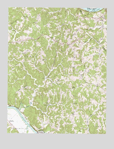
Mount Alto, WV USGS Topographic Map
Click on map above to begin viewing in our Map Viewer.

This topographic map contains these locations and features:
Feature Name Type Latitude Longitude GNIS ID View Map
AshPopulated PlaceN38.8326°W81.9735°1560640View Map
BadenPopulated PlaceN38.7984°W81.8874°1549577View Map
Baden Baptist ChurchChurchN38.7940°W81.8876°1678881View Map
Baden CemeteryCemeteryN38.8076°W81.9060°1678882View Map
Baden CemeteryCemeteryN38.7937°W81.8874°1678883View Map
Baden Presbyterian ChurchChurchN38.8073°W81.9065°1535109View Map
Barnett ForkStreamN38.8184°W81.9340°1535267View Map
Bearwallow School (historical)SchoolN38.8229°W81.9565°1535435View Map
Beech Hill Station (historical)LocaleN38.7770°W81.9971°1560134View Map
Bethel CemeteryCemeteryN38.7954°W81.9165°1678888View Map
Bethel ChurchChurchN38.7951°W81.9154°1535701View Map
Bug RunStreamN38.8031°W81.9532°1536674View Map
Bug Run School (historical)SchoolN38.8017°W81.9371°1536675View Map
Carl McDale SpringSpringN38.8331°W81.9540°1560151View Map
ChestnutPopulated PlaceN38.8390°W81.9221°1560154View Map
Chestnut RidgeRidgeN38.8495°W81.9140°1537293View Map
Cleon Cadle SpringSpringN38.7954°W81.9118°1560158View Map
Clifford Vickers SpringSpringN38.8056°W81.9815°1560159View Map
Cologne DistrictCivilN38.7960°W81.9141°1928197View Map
Cooper DistrictCivilN38.8492°W81.9860°1928198View Map
Cooper ForkStreamN38.7779°W81.9707°1537652View Map
Davies Grove ChurchChurchN38.8651°W81.9757°1538020View Map
Dowell SpringSpringN38.7551°W81.9535°1560171View Map
Everett Keefer SpringSpringN38.7868°W81.8885°1560182View Map
Excelsior School (historical)SchoolN38.8615°W81.9818°1560183View Map
Forked Pine School (historical)SchoolN38.7765°W81.8960°1560190View Map
Gill School (historical)SchoolN38.8634°W81.9632°1560196View Map
Gill SpringSpringN38.8634°W81.9618°1560197View Map
Greenlee CemeteryCemeteryN38.7745°W81.9576°1539714View Map
Guy Midturn SpringSpringN38.8451°W81.9635°1560204View Map
Harmony School (historical)SchoolN38.8117°W81.9957°1560207View Map
Harold Sayre SpringSpringN38.8717°W81.9446°1560209View Map
Harvey ChapelChurchN38.8045°W81.9499°1540041View Map
Hill School (historical)SchoolN38.7779°W81.9487°1540294View Map
Homer Peck SpringSpringN38.7929°W81.9882°1560220View Map
Hopedale School (historical)SchoolN38.7562°W81.9337°1560221View Map
Hopewell Baptist Church CemeteryCemeteryN38.8627°W81.8800°2726744View Map
Hopewell ChurchChurchN38.8626°W81.8799°1540445View Map
Howell School (historical)SchoolN38.8656°W81.9387°1560222View Map
Huff RunStreamN38.8340°W81.8840°1540556View Map
Huff School (historical)SchoolN38.8340°W81.8832°1560226View Map
Jackson Chapel CemeteryCemeteryN38.8444°W81.8833°2726756View Map
Jenkins CemeteryCemeteryN38.7801°W81.9512°1540858View Map
Kings BranchStreamN38.8081°W81.9724°1541218View Map
Leo Roush SpringSpringN38.8667°W81.9754°1560235View Map
Leo Roush SpringSpringN38.8673°W81.9749°1560236View Map
LeonPopulated PlaceN38.7506°W81.9607°1541786View Map
Leon Post OfficePost OfficeN38.7504°W81.9602°1560237View Map
Leon Volunteer Fire DepartmentBuildingN38.7504°W81.9536°2578038View Map
Lick ForkStreamN38.8054°W81.9529°1541894View Map
Little Mill CreekStreamN38.8456°W81.8940°1542172View Map
Maupin LandingLocaleN38.8001°W81.9499°1549543View Map
Morgan CemeteryCemeteryN38.8426°W81.9387°1543534View Map
Mount AltoPopulated PlaceN38.8645°W81.8782°1555165View Map
Mount Alto Post OfficePost OfficeN38.8656°W81.8818°1559998View Map
Mount Flower CemeteryCemeteryN38.8376°W81.9282°2728446View Map
Mount Hebron ChurchChurchN38.8445°W81.8824°1552202View Map
Mount Moriah ChurchChurchN38.8592°W81.9646°1543678View Map
Mount Olive ChurchChurchN38.8442°W81.9437°1543709View Map
Mount Zion CemeteryCemeteryN38.8298°W81.9785°1678904View Map
Mount Zion ChurchChurchN38.8298°W81.9787°1543827View Map
Mountain Flower School (historical)SchoolN38.8165°W81.9154°1543858View Map
Oscar Weigand SpringSpringN38.8679°W81.9371°1560278View Map
Oscar Weigand SpringSpringN38.8673°W81.9368°1560279View Map
Oscar Weigand SpringSpringN38.8665°W81.9365°1560280View Map
Otis Randolph SpringSpringN38.8420°W81.9426°1560281View Map
Pine Grove CemeteryCemeteryN38.7787°W81.9157°1678908View Map
Pine Grove ChurchChurchN38.7795°W81.9162°1544882View Map
Plants RidgeRidgeN38.8151°W81.9910°1544974View Map
Plants RunStreamN38.7967°W81.9621°1544975View Map
Pond BranchStreamN38.7573°W81.9737°1545123View Map
Red Mud School (historical)SchoolN38.8126°W81.8885°1560297View Map
Roanoke School (historical)SchoolN38.8626°W81.9112°1560299View Map
RollinsPopulated PlaceN38.8054°W81.9501°1555519View Map
Rollins Dam Number OneDamN38.8251°W81.8865°1558916View Map
Rollins Lake Number Two DamDamN38.8251°W81.8832°1558917View Map
Rollins SpringSpringN38.7940°W81.9365°1560302View Map
Runion SpringSpringN38.7917°W81.9857°1560303View Map
Sayre CemeteryCemeteryN38.8634°W81.9118°1546471View Map
Shiloh ChurchChurchN38.7776°W81.9493°1546685View Map
Tenmile CreekStreamN38.7742°W81.9868°1547963View Map
Thirteenmile CreekStreamN38.7509°W81.9618°1548017View Map
Thomas RidgeRidgeN38.8304°W81.9804°1548032View Map
Thomas School (historical)SchoolN38.8312°W81.9718°1560319View Map
Toms RunStreamN38.8717°W81.8960°1548146View Map
Union School (historical)SchoolN38.7951°W81.9776°1548492View Map
Ward CemeteryCemeteryN38.8612°W81.9474°1548789View Map
WoodPopulated PlaceN38.7715°W81.9154°1560332View Map
Wood School (historical)SchoolN38.7693°W81.9149°1549366View Map
Yauger ChurchChurchN38.7948°W81.9785°1549446View Map
Yauger Church CemeteryCemeteryN38.7942°W81.9785°1678919View Map
Yauger RidgeRidgeN38.7934°W81.9818°1549447View Map
Yeager School (historical)SchoolN38.8029°W81.9040°1560337View Map

Note: Coordinates in the location and feature list above are referenced to NAD83 datum.


Copyright (C) 2008-2025 Ryan Niemi / Sunset Dynamics ... All Rights Reserved