TopoQuest Logo
Do you find TopoQuest useful?
Help keep TopoQuest running and adding new maps/features by donating!
Bitcoin:  19c7KJd3qBynnjoSw5npx9KScwjBe4ifkT
Litecoin:  LXs6TkuXGGXo1vDsWCkWVdjQX94eUKd6ui
Home View Maps Find Maps Find Places Resources & Links


Mount Arter SE, Wyoming Topographic Map

USGS Map Title: Mount Arter SE, WY
USGS Map MRC: 42108G7
DRG (GeoTIFF) Download: o42108g7.tif


Neighboring USGS Topographic Map Quads:


  Wind River, WY  
42108H8
 

  Ray Lake, WY  
42108H7
 

  Lander NW, WY  
42108H6
 

  Mount Arter, WY  
42108G8
 

  Mount Arter SE, WY  
42108G7
 

  Lander, WY  
42108G6
 

  Cony Mountain, WY  
42108F8
 

  Fossil Hill, WY  
42108F7
 

  Wolf Point, WY  
42108F6


Map MRC Location:

N43°
W109°
N43°
W108°
H8 H7 H6 H5 H4 H3 H2 H1
G8 G7 G6 G5 G4 G3 G2 G1
F8 F7 F6 F5 F4 F3 F2 F1
E8 E7 E6 E5 E4 E3 E2 E1
D8 D7 D6 D5 D4 D3 D2 D1
C8 C7 C6 C5 C4 C3 C2 C1
B8 B7 B6 B5 B4 B3 B2 B1
A8 A7 A6 A5 A4 A3 A2 A1
N42°
W109°
N42°
W108°

Mount Arter SE, WY USGS 1:24K Topographic Map Preview:
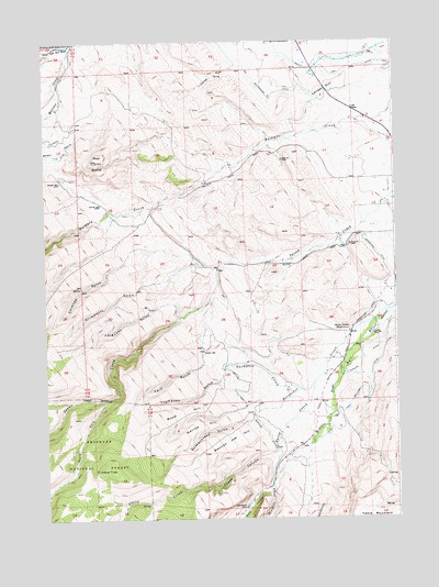
Mount Arter SE, WY USGS Topographic Map
Click on map above to begin viewing in our Map Viewer.

This topographic map contains these locations and features:
Feature Name Type Latitude Longitude GNIS ID View Map
Baldwin Creek MineMineN42.8333°W108.8535°1746496View Map
Baldwin Creek SchoolLocaleN42.8327°W108.8304°1597898View Map
Big Cottonwood DitchCanalN42.8661°W108.8007°1598133View Map
Borner Garden CemeteryCemeteryN42.8048°W108.7583°2774457View Map
Borner Garden SchoolSchoolN42.7988°W108.7671°1598307View Map
Chimney GulchValleyN42.8180°W108.8462°1598736View Map
City of LanderCivilN42.8313°W108.7599°2411622View Map
Ferguson GulchValleyN42.8030°W108.8271°1599690View Map
Gaylor and Warnock DitchCanalN42.7772°W108.8021°1599915View Map
Grimmetts GulchValleyN42.8119°W108.8354°1600097View Map
Hornecker Ranch MineMineN42.7763°W108.8340°1746497View Map
KDLY-FM (Lander)TowerN42.8222°W108.7640°1608926View Map
Kimbal DrawValleyN42.8688°W108.8057°1600719View Map
Lander Area Number Two MineMineN42.8333°W108.8340°1746498View Map
Lander HillSummitN42.8627°W108.7740°1600830View Map
Lander Valley High SchoolSchoolN42.8415°W108.7511°1795482View Map
Mexican CreekStreamN42.8741°W108.8654°1601364View Map
Mexican Joe HillSummitN42.7702°W108.8115°1601365View Map
Narrow HillSummitN42.7747°W108.8207°1601656View Map
North Fork DitchCanalN42.8675°W108.7676°1601759View Map
Quakenstead GulchValleyN42.7772°W108.8021°1602335View Map
Red ButteSummitN42.8438°W108.8560°1602416View Map
Sandstone DitchCanalN42.8191°W108.7571°1602725View Map
Sawmill CreekStreamN42.7583°W108.7951°1602745View Map
Sheep CanyonValleyN42.7675°W108.7943°1602826View Map
Sheep CreekStreamN42.7850°W108.7798°1602834View Map
Sinks CanyonValleyN42.7580°W108.7965°1602937View Map
Sinks Canyon MineMineN42.7602°W108.7923°1746500View Map
South Fork Squaw CreekStreamN42.7811°W108.8540°1604476View Map
Squaw Creek MineMineN42.8047°W108.8340°1746501View Map
Standish DitchCanalN42.8508°W108.8679°1603330View Map
Table MountainSummitN42.7505°W108.7523°1598989View Map
Thompson CreekStreamN42.7836°W108.7846°1603634View Map
Thompson Creek MineMineN42.7855°W108.8340°1746502View Map
Thompson GulchValleyN42.7894°W108.8118°1603635View Map
Timber TopSummitN42.7636°W108.8548°1603675View Map
Twin GulchValleyN42.7944°W108.8187°1603828View Map
Wood HillSummitN42.7780°W108.8271°1604276View Map

Note: Coordinates in the location and feature list above are referenced to NAD83 datum.


Copyright (C) 2008-2024 Ryan Niemi / Sunset Dynamics ... All Rights Reserved