TopoQuest Logo
Do you find TopoQuest useful?
Help keep TopoQuest running and adding new maps/features by donating!
Bitcoin:  19c7KJd3qBynnjoSw5npx9KScwjBe4ifkT
Litecoin:  LXs6TkuXGGXo1vDsWCkWVdjQX94eUKd6ui
Home View Maps Find Maps Find Places Resources & Links


Ray Lake, Wyoming Topographic Map

USGS Map Title: Ray Lake, WY
USGS Map MRC: 42108H7
DRG (GeoTIFF) Download: o42108h7.tif


Neighboring USGS Topographic Map Quads:


  Fort Washakie, WY  
43108A8
 

  Ethete, WY  
43108A7
 

  Mule Butte, WY  
43108A6
 

  Wind River, WY  
42108H8
 

  Ray Lake, WY  
42108H7
 

  Lander NW, WY  
42108H6
 

  Mount Arter, WY  
42108G8
 

  Mount Arter SE, WY  
42108G7
 

  Lander, WY  
42108G6


Map MRC Location:

N43°
W109°
N43°
W108°
H8 H7 H6 H5 H4 H3 H2 H1
G8 G7 G6 G5 G4 G3 G2 G1
F8 F7 F6 F5 F4 F3 F2 F1
E8 E7 E6 E5 E4 E3 E2 E1
D8 D7 D6 D5 D4 D3 D2 D1
C8 C7 C6 C5 C4 C3 C2 C1
B8 B7 B6 B5 B4 B3 B2 B1
A8 A7 A6 A5 A4 A3 A2 A1
N42°
W109°
N42°
W108°

Ray Lake, WY USGS 1:24K Topographic Map Preview:
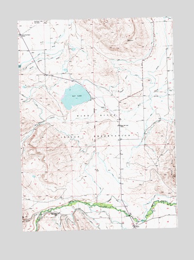
Ray Lake, WY USGS Topographic Map
Click on map above to begin viewing in our Map Viewer.

This topographic map contains these locations and features:
Feature Name Type Latitude Longitude GNIS ID View Map
Boulder FlatsPopulated PlaceN42.9127°W108.7990°1853198View Map
Boulder Flats Census Designated PlaceCensusN42.9156°W108.7993°2407893View Map
Coolidge CanalCanalN42.9755°W108.7596°1586951View Map
Dead Horse SloughStreamN42.9861°W108.8432°1587412View Map
Fort Washakie Elementary SchoolSchoolN42.9993°W108.8547°1795502View Map
Fort Washakie Junior High SchoolSchoolN42.9994°W108.8559°1795501View Map
Fremont County Fire Protection District Battalion 3 Lander Rural Station 2BuildingN42.8773°W108.7830°2673521View Map
Latter Day Saints ChurchChurchN42.9916°W108.8729°1590578View Map
McCaskey DrainStreamN42.9580°W108.7698°1591296View Map
MilfordPopulated PlaceN42.8763°W108.7843°1597406View Map
Milford CemeteryCemeteryN42.8758°W108.7848°2774462View Map
North Fork Masonic CemeteryCemeteryN42.8828°W108.7577°2774464View Map
Ray CanalCanalN42.9247°W108.8279°1593218View Map
Ray DamDamN42.9583°W108.8340°1608226View Map
Ray LakeReservoirN42.9533°W108.8176°1593219View Map
Ray ReservoirReservoirN42.9542°W108.8295°1608227View Map
Surrell CreekStreamN42.8858°W108.8607°1603460View Map
Upper Milford SchoolLocaleN42.8852°W108.8462°1595867View Map
Upper Mill Creek SchoolSchoolN42.9366°W108.7940°1595868View Map
White Horse DrawValleyN42.9913°W108.8368°1596307View Map
Wind River Day SchoolSchoolN42.9991°W108.8557°1596516View Map
Wind River Mountain Front Number Six MineMineN42.9625°W108.8715°1726443View Map
Wind River Mountain Front Number Three MineMineN42.8972°W108.8673°1726442View Map
Wyoming Indian Elementary SchoolSchoolN42.9809°W108.7688°1795500View Map

Note: Coordinates in the location and feature list above are referenced to NAD83 datum.


Copyright (C) 2008-2025 Ryan Niemi / Sunset Dynamics ... All Rights Reserved