TopoQuest Logo
Do you find TopoQuest useful?
Help keep TopoQuest running and adding new maps/features by donating!
Bitcoin:  19c7KJd3qBynnjoSw5npx9KScwjBe4ifkT
Litecoin:  LXs6TkuXGGXo1vDsWCkWVdjQX94eUKd6ui
Home View Maps Find Maps Find Places Resources & Links


Beechwood, Indiana Topographic Map

USGS Map Title: Beechwood, IN
USGS Map MRC: 38086B4
DRG (GeoTIFF) Download: o38086b4.tif


Neighboring USGS Topographic Map Quads:


  Taswell, IN  
38086C5
 

  English, IN  
38086C4
 

  Milltown, IN  
38086C3
 

  Branchville, IN  
38086B5
 

  Beechwood, IN  
38086B4
 

  Leavenworth, IN  
38086B3
 

  Derby, IN  
38086A5
 

  Alton, IN  
38086A4
 

  New Amsterdam, IN  
38086A3


Map MRC Location:

N39°
W87°
N39°
W86°
H8 H7 H6 H5 H4 H3 H2 H1
G8 G7 G6 G5 G4 G3 G2 G1
F8 F7 F6 F5 F4 F3 F2 F1
E8 E7 E6 E5 E4 E3 E2 E1
D8 D7 D6 D5 D4 D3 D2 D1
C8 C7 C6 C5 C4 C3 C2 C1
B8 B7 B6 B5 B4 B3 B2 B1
A8 A7 A6 A5 A4 A3 A2 A1
N38°
W87°
N38°
W86°

Beechwood, IN USGS 1:24K Topographic Map Preview:
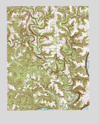
Beechwood, IN USGS Topographic Map
Click on map above to begin viewing in our Map Viewer.

This topographic map contains these locations and features:
Feature Name Type Latitude Longitude GNIS ID View Map
BeechwoodPopulated PlaceN38.2067°W86.4244°450671View Map
Birds CemeteryCemeteryN38.1601°W86.4172°450683View Map
Bloom Riddle CemeteryCemeteryN38.1700°W86.4355°451394View Map
Buzzard Roost Lookout TowerTowerN38.1270°W86.4658°450742View Map
Crawford ChurchChurchN38.2051°W86.3761°450812View Map
DeucharsPopulated PlaceN38.1723°W86.4483°450844View Map
English Volunteer Fire Department Union StationBuildingN38.2319°W86.4779°2626045View Map
FredoniaPopulated PlaceN38.1781°W86.3830°450931View Map
Harvey Flat ChurchChurchN38.1615°W86.4269°451019View Map
Jaby CreekStreamN38.2392°W86.3961°451092View Map
Jeffries CemeteryCemeteryN38.1847°W86.4884°451098View Map
JerichoPopulated PlaceN38.1992°W86.4244°451099View Map
Low Gap BranchStreamN38.1634°W86.4000°451177View Map
MagnoliaPopulated PlaceN38.2492°W86.3930°451193View Map
Mill CreekStreamN38.1301°W86.4125°451217View Map
Old Chapel CemeteryCemeteryN38.1281°W86.4941°451296View Map
Old Union CemeteryCemeteryN38.2178°W86.4929°2677870View Map
Old Union ChurchChurchN38.2179°W86.4932°451298View Map
Orchard Hill CemeteryCemeteryN38.1298°W86.4264°451305View Map
Oriole LakeReservoirN38.1849°W86.4917°451307View Map
Pleasant Ridge ChurchChurchN38.1376°W86.3755°451343View Map
Sheckell CemeteryCemeteryN38.1345°W86.4082°451448View Map
Stinking ForkStreamN38.1917°W86.4536°451512View Map
SulphurPopulated PlaceN38.2276°W86.4708°451522View Map
Sulphur Lake Picinic AreaParkN38.2320°W86.4886°451527View Map
Sulphur SpringsPopulated PlaceN38.2120°W86.4750°451528View Map
Township of BooneCivilN38.1539°W86.4354°453126View Map
Township of OhioCivilN38.1885°W86.4065°453683View Map
Turkey ForkStreamN38.1620°W86.4075°451585View Map
Wiseman CemeteryCemeteryN38.2019°W86.4372°451641View Map

Note: Coordinates in the location and feature list above are referenced to NAD83 datum.


Copyright (C) 2008-2024 Ryan Niemi / Sunset Dynamics ... All Rights Reserved