TopoQuest Logo
Do you find TopoQuest useful?
Help keep TopoQuest running and adding new maps/features by donating!
Bitcoin:  19c7KJd3qBynnjoSw5npx9KScwjBe4ifkT
Litecoin:  LXs6TkuXGGXo1vDsWCkWVdjQX94eUKd6ui
Home View Maps Find Maps Find Places Resources & Links


Mount Gilead East, North Carolina Topographic Map

USGS Map Title: Mount Gilead East, NC
USGS Map MRC: 35079B8
DRG (GeoTIFF) Download: o35079b8.tif


Neighboring USGS Topographic Map Quads:


  Morrow Mountain, NC  
35080C1
 

  Troy, NC  
35079C8
 

  Biscoe, NC  
35079C7
 

  Mount Gilead West, NC  
35080B1
 

  Mount Gilead East, NC  
35079B8
 

  Harrisville, NC  
35079B7
 

  Ansonville, NC  
35080A1
 

  Mangum, NC  
35079A8
 

  Ellerbe, NC  
35079A7


Map MRC Location:

N36°
W80°
N36°
W79°
H8 H7 H6 H5 H4 H3 H2 H1
G8 G7 G6 G5 G4 G3 G2 G1
F8 F7 F6 F5 F4 F3 F2 F1
E8 E7 E6 E5 E4 E3 E2 E1
D8 D7 D6 D5 D4 D3 D2 D1
C8 C7 C6 C5 C4 C3 C2 C1
B8 B7 B6 B5 B4 B3 B2 B1
A8 A7 A6 A5 A4 A3 A2 A1
N35°
W80°
N35°
W79°

Mount Gilead East, NC USGS 1:24K Topographic Map Preview:
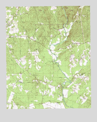
Mount Gilead East, NC USGS Topographic Map
Click on map above to begin viewing in our Map Viewer.

This topographic map contains these locations and features:
Feature Name Type Latitude Longitude GNIS ID View Map
Aleks BranchStreamN35.2288°W79.9006°1008668View Map
Big Town CreekStreamN35.1810°W79.9248°1009388View Map
Big Wolf BranchStreamN35.1729°W79.9756°1009392View Map
Cedar BranchStreamN35.2238°W79.9303°1010113View Map
Cheek CreekStreamN35.1590°W79.9056°1023901View Map
Disons CreekStreamN35.2026°W79.9342°1023948View Map
Dry CreekStreamN35.1824°W79.8787°1010916View Map
Flat Lick BranchStreamN35.1740°W79.8878°1011264View Map
Hamer CreekStreamN35.1351°W79.9156°1011816View Map
Highland Middle SchoolSchoolN35.2285°W79.9981°1017620View Map
Holly Mount ChurchChurchN35.2435°W79.8756°1012141View Map
Ingram ChapelChurchN35.1971°W79.9537°1012361View Map
Jordan FieldAirportN35.2408°W79.9927°2679232View Map
Ledbetter CemeteryCemeteryN35.1507°W79.9212°1012775View Map
Little CreekStreamN35.2404°W79.8942°1012944View Map
Little River ChurchChurchN35.2038°W79.9014°1013015View Map
Little Rocky CreekStreamN35.2024°W79.9353°1013019View Map
Little Town CreekStreamN35.1829°W79.9364°1013037View Map
Littles MillLocaleN35.1526°W79.9178°1021248View Map
Middle Prong Hamer CreekStreamN35.1335°W79.9709°1013511View Map
Mount Airy ChurchChurchN35.1318°W79.9970°1013726View Map
Mountain Grove ChurchChurchN35.1665°W79.9598°1013797View Map
North Carolina State ReservationReserveN35.1824°W79.9298°1018121View Map
Oak Ridge ChurchChurchN35.2279°W79.9962°1014062View Map
Olive Grove ChurchChurchN35.1304°W79.9853°1014112View Map
Pee Dee ChurchChurchN35.1426°W79.9423°1014298View Map
Pleasant Grove ChurchChurchN35.1968°W79.9942°1014513View Map
Sharon CemeteryCemeteryN35.2137°W79.9795°1015385View Map
Snow Hill ChurchChurchN35.1324°W79.9256°1015642View Map
Stanback ParkParkN35.2160°W79.9978°1017877View Map
Susies CreekStreamN35.1871°W79.9251°1015962View Map
Thickety CreekStreamN35.2176°W79.9114°1024348View Map
Town Creek Indian MoundLocaleN35.1826°W79.9292°1016202View Map
Town Creek Indian Mound State Historic SiteParkN35.1824°W79.9298°1017880View Map
Township of Cheek CreekCivilN35.2249°W79.8760°1026957View Map
Township of Mount GileadCivilN35.2212°W79.9762°1026960View Map
Township of SteelesCivilN35.1263°W79.9151°1027099View Map
Uwbarrie Game LandParkN35.2440°W79.8978°1017999View Map
Uwharrie Game LandParkN35.2440°W79.8989°1018076View Map

Note: Coordinates in the location and feature list above are referenced to NAD83 datum.


Copyright (C) 2008-2025 Ryan Niemi / Sunset Dynamics ... All Rights Reserved