TopoQuest Logo
Do you find TopoQuest useful?
Help keep TopoQuest running and adding new maps/features by donating!
Bitcoin:  19c7KJd3qBynnjoSw5npx9KScwjBe4ifkT
Litecoin:  LXs6TkuXGGXo1vDsWCkWVdjQX94eUKd6ui
Home View Maps Find Maps Find Places Resources & Links


Mount Gilead West, North Carolina Topographic Map

USGS Map Title: Mount Gilead West, NC
USGS Map MRC: 35080B1
DRG (GeoTIFF) Download: o35080b1.tif


Neighboring USGS Topographic Map Quads:


  Albemarle, NC  
35080C2
 

  Morrow Mountain, NC  
35080C1
 

  Troy, NC  
35079C8
 

  Aquadale, NC  
35080B2
 

  Mount Gilead West, NC  
35080B1
 

  Mount Gilead East, NC  
35079B8
 

  Polkton, NC  
35080A2
 

  Ansonville, NC  
35080A1
 

  Mangum, NC  
35079A8


Map MRC Location:

N36°
W81°
N36°
W80°
H8 H7 H6 H5 H4 H3 H2 H1
G8 G7 G6 G5 G4 G3 G2 G1
F8 F7 F6 F5 F4 F3 F2 F1
E8 E7 E6 E5 E4 E3 E2 E1
D8 D7 D6 D5 D4 D3 D2 D1
C8 C7 C6 C5 C4 C3 C2 C1
B8 B7 B6 B5 B4 B3 B2 B1
A8 A7 A6 A5 A4 A3 A2 A1
N35°
W81°
N35°
W80°

Mount Gilead West, NC USGS 1:24K Topographic Map Preview:
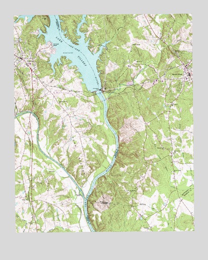
Mount Gilead West, NC USGS Topographic Map
Click on map above to begin viewing in our Map Viewer.

This topographic map contains these locations and features:
Feature Name Type Latitude Longitude GNIS ID View Map
Allenton (historical)LocaleN35.2251°W80.0976°1001939View Map
Bethel ChurchChurchN35.2229°W80.0395°981123View Map
Big BranchStreamN35.2285°W80.0223°1009276View Map
Big Cedar CreekStreamN35.1935°W80.1223°981371View Map
Bunny CreekStreamN35.2229°W80.0976°982262View Map
Buzzard IslandIslandN35.1474°W80.0787°982352View Map
Camp BranchStreamN35.1574°W80.0870°982505View Map
Cedar HillPopulated PlaceN35.1429°W80.1181°1019578View Map
Center Rural Volunteer Fire DepartmentBuildingN35.2232°W80.1189°2639821View Map
Chestnut ChurchChurchN35.1268°W80.0317°983097View Map
Clarks CreekStreamN35.2004°W80.0609°1023908View Map
Edinboro (historical)LocaleN35.2376°W80.0914°1001945View Map
First Health of the Carolinas Emergency Medical Services Base 2BuildingN35.2133°W80.0014°2720456View Map
Fork SectionRidgeN35.1710°W80.0814°985306View Map
Hamer Creek ChurchChurchN35.1479°W80.0445°986335View Map
HydroLocaleN35.2065°W80.0603°997699View Map
Lake TilleryReservoirN35.2211°W80.0863°1024351View Map
Lily BridgeBridgeN35.2321°W80.0631°988488View Map
Little Cedar CreekStreamN35.1915°W80.1087°988567View Map
Lower Richland CreekStreamN35.2346°W80.0581°1013246View Map
Melton Grove ChurchChurchN35.1701°W80.0139°989714View Map
Morgan MountainSummitN35.2474°W80.1012°1021532View Map
Mount GileadPopulated PlaceN35.2149°W80.0023°1013735View Map
Mount Gilead (historical)LocaleN35.2185°W80.0248°1001952View Map
Mount Gilead Elementary SchoolSchoolN35.2132°W80.0020°1006709View Map
Mount Gilead Police DepartmentBuildingN35.2146°W80.0026°2769652View Map
Mount Gilead Post OfficePost OfficeN35.2155°W80.0037°2774214View Map
Mount Gilead Volunteer Fire DepartmentBuildingN35.2147°W80.0010°2638102View Map
North Prong Buffalo CreekStreamN35.1310°W80.1156°991257View Map
NorwoodPopulated PlaceN35.2196°W80.1189°1021677View Map
Norwood BeachPopulated PlaceN35.2329°W80.0989°1021678View Map
Norwood DamDamN35.2065°W80.0662°991319View Map
Norwood Fire DepartmentBuildingN35.2259°W80.1193°2638368View Map
Norwood Police DepartmentBuildingN35.2253°W80.1208°2769623View Map
Norwood Post OfficePost OfficeN35.2233°W80.1158°2773996View Map
Norwood SchoolSchoolN35.2210°W80.1151°1001955View Map
Providence ChurchChurchN35.1976°W80.0153°992865View Map
Richland CreekStreamN35.2340°W80.0778°1014874View Map
Rocky RiverStreamN35.1432°W80.0764°1024276View Map
Saint Lukes ChurchChurchN35.2276°W80.0112°993990View Map
Saint Stephen ChurchChurchN35.1476°W80.0445°994129View Map
Shankel Grove ChurchChurchN35.1993°W80.0937°994575View Map
ShankleLocaleN35.1865°W80.0851°1001961View Map
South Prong Buffalo CreekStreamN35.1307°W80.1156°995192View Map
Springer LakeReservoirN35.1285°W80.1214°998417View Map
Springer Lake DamDamN35.1285°W80.1214°998416View Map
Thomasville ChurchChurchN35.1724°W80.0206°996043View Map
Town of Mount GileadCivilN35.2164°W80.0050°2406206View Map
Town of NorwoodCivilN35.2338°W80.1141°2407011View Map
Township of CenterCivilN35.2252°W80.1216°1027193View Map
Walts ChapelChurchN35.2326°W80.0420°996762View Map
West Prong Hamer CreekStreamN35.1521°W80.0009°997036View Map

Note: Coordinates in the location and feature list above are referenced to NAD83 datum.


Copyright (C) 2008-2025 Ryan Niemi / Sunset Dynamics ... All Rights Reserved