TopoQuest Logo
Do you find TopoQuest useful?
Help keep TopoQuest running and adding new maps/features by donating!
Bitcoin:  19c7KJd3qBynnjoSw5npx9KScwjBe4ifkT
Litecoin:  LXs6TkuXGGXo1vDsWCkWVdjQX94eUKd6ui
Home View Maps Find Maps Find Places Resources & Links


Morrow Mountain, North Carolina Topographic Map

USGS Map Title: Morrow Mountain, NC
USGS Map MRC: 35080C1
DRG (GeoTIFF) Download: o35080c1.tif


Neighboring USGS Topographic Map Quads:


  New London, NC  
35080D2
 

  Badin, NC  
35080D1
 

  Lovejoy, NC  
35079D8
 

  Albemarle, NC  
35080C2
 

  Morrow Mountain, NC  
35080C1
 

  Troy, NC  
35079C8
 

  Aquadale, NC  
35080B2
 

  Mount Gilead West, NC  
35080B1
 

  Mount Gilead East, NC  
35079B8


Map MRC Location:

N36°
W81°
N36°
W80°
H8 H7 H6 H5 H4 H3 H2 H1
G8 G7 G6 G5 G4 G3 G2 G1
F8 F7 F6 F5 F4 F3 F2 F1
E8 E7 E6 E5 E4 E3 E2 E1
D8 D7 D6 D5 D4 D3 D2 D1
C8 C7 C6 C5 C4 C3 C2 C1
B8 B7 B6 B5 B4 B3 B2 B1
A8 A7 A6 A5 A4 A3 A2 A1
N35°
W81°
N35°
W80°

Morrow Mountain, NC USGS 1:24K Topographic Map Preview:
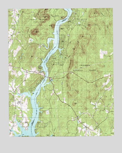
Morrow Mountain, NC USGS Topographic Map
Click on map above to begin viewing in our Map Viewer.

This topographic map contains these locations and features:
Feature Name Type Latitude Longitude GNIS ID View Map
Big Island CreekStreamN35.3726°W80.0476°1009328View Map
Buzzard MountainSummitN35.3074°W80.0531°1000987View Map
Carolina ForestPopulated PlaceN35.3618°W80.0517°1024535View Map
Cattail CreekStreamN35.2946°W80.0514°1023887View Map
Cedar CreekStreamN35.2526°W80.1059°1023896View Map
Dennis MountainSummitN35.3474°W80.0378°1000993View Map
Dumas CreekStreamN35.2907°W80.0162°1020048View Map
Emerald ShoresPopulated PlaceN35.2504°W80.0806°1001091View Map
Hall BranchStreamN35.2524°W80.0037°1024020View Map
Hattaway MountainSummitN35.3740°W80.0817°1024028View Map
Holiday ShoresPopulated PlaceN35.3421°W80.0609°1024533View Map
Horse Trough MountainSummitN35.3204°W80.0495°1000990View Map
Jacobs CreekStreamN35.2882°W80.0934°1012416View Map
Lake in the PinePopulated PlaceN35.3629°W80.0362°1024536View Map
Lake Tillery Volunteer Fire Department and Rescue Squad 10BuildingN35.3025°W80.0735°2639791View Map
Lather BranchStreamN35.2801°W80.0212°1024079View Map
Lawrenceville (historical)LocaleN35.3104°W80.0456°1017625View Map
Lick ForkStreamN35.2571°W80.0159°1024087View Map
Lick MountainSummitN35.3701°W80.0201°1000996View Map
Little Island CreekStreamN35.3601°W80.0395°1024099View Map
Little Mountain CreekStreamN35.3610°W80.1137°1024103View Map
Mill MountainSummitN35.3660°W80.0589°1024719View Map
Morrow MountainSummitN35.3524°W80.0928°1024165View Map
Mount Zion ChurchChurchN35.2688°W80.0428°1024720View Map
Mountain CreekStreamN35.3449°W80.0701°1024174View Map
Pee DeePopulated PlaceN35.2676°W80.0431°1014297View Map
Randell ChurchChurchN35.2646°W80.1051°1024244View Map
River HavenPopulated PlaceN35.3154°W80.0856°1024266View Map
Rocky CreekStreamN35.2996°W80.0837°1015036View Map
Rocky Hill ChurchChurchN35.3518°W80.1134°1024274View Map
Shelter MountainSummitN35.2824°W80.0467°1001089View Map
Shiloh ChurchChurchN35.3718°W80.1076°1024718View Map
Stony ForkStreamN35.2771°W80.0162°1024324View Map
Stony Fork ChurchChurchN35.2751°W80.0106°1015865View Map
Stony Hill ChurchChurchN35.3521°W80.1131°1000988View Map
Stony MountainSummitN35.3288°W80.0981°1024325View Map
Stony Mountain Lake Number OneReservoirN35.3271°W80.1103°1017173View Map
Stony Mountain Lake Number TwoReservoirN35.3301°W80.1081°1017170View Map
Stony Mountain Number One DamDamN35.3318°W80.1064°1017172View Map
Stony Mountain Number Two DamDamN35.3301°W80.1081°1017171View Map
Sugarloaf CreekStreamN35.3629°W80.0670°1000989View Map
Sugarloaf MountainSummitN35.3663°W80.0778°1024332View Map
Sugarloaf ShoresPopulated PlaceN35.3560°W80.0631°1024534View Map
Swift Island (historical)LocaleN35.3063°W80.0717°1017624View Map
Tater Top MountainSummitN35.3579°W80.0712°1024344View Map
Tindalsville (historical)LocaleN35.3699°W80.0559°1017398View Map
Township of Pee DeeCivilN35.2679°W80.0449°1026962View Map
Township of UwharrieCivilN35.3634°W80.0100°1026966View Map
Upper Wood RunStreamN35.3346°W80.0614°1024375View Map
Uwharrie National Recreation TrailTrailN35.3746°W80.0173°1023769View Map
Walker MountainSummitN35.3354°W80.0442°1000992View Map
White Crest ChurchChurchN35.3196°W80.0609°1016584View Map
Wood RunStreamN35.3354°W80.0653°1024414View Map
WoodrunPopulated PlaceN35.3251°W80.0712°1000991View Map
Zion ChurchChurchN35.2735°W80.0376°1016890View Map

Note: Coordinates in the location and feature list above are referenced to NAD83 datum.


Copyright (C) 2008-2024 Ryan Niemi / Sunset Dynamics ... All Rights Reserved