TopoQuest Logo
Do you find TopoQuest useful?
Help keep TopoQuest running and adding new maps/features by donating!
Bitcoin:  19c7KJd3qBynnjoSw5npx9KScwjBe4ifkT
Litecoin:  LXs6TkuXGGXo1vDsWCkWVdjQX94eUKd6ui
Home View Maps Find Maps Find Places Resources & Links


Mount McLoughlin, Oregon Topographic Map

USGS Map Title: Mount McLoughlin, OR
USGS Map MRC: 42122D3
DRG (GeoTIFF) Download: o42122d3.tif


Neighboring USGS Topographic Map Quads:


  Big Butte Springs, OR  
42122E4
 

  Rustler Peak, OR  
42122E3
 

  Pelican Butte, OR  
42122E2
 

  Willow Lake, OR  
42122D4
 

  Mount McLoughlin, OR  
42122D3
 

  Lake of the Woods North, OR  
42122D2
 

  Robinson Butte, OR  
42122C4
 

  Brown Mountain, OR  
42122C3
 

  Lake of the Woods South, OR  
42122C2


Map MRC Location:

N43°
W123°
N43°
W122°
H8 H7 H6 H5 H4 H3 H2 H1
G8 G7 G6 G5 G4 G3 G2 G1
F8 F7 F6 F5 F4 F3 F2 F1
E8 E7 E6 E5 E4 E3 E2 E1
D8 D7 D6 D5 D4 D3 D2 D1
C8 C7 C6 C5 C4 C3 C2 C1
B8 B7 B6 B5 B4 B3 B2 B1
A8 A7 A6 A5 A4 A3 A2 A1
N42°
W123°
N42°
W122°

Mount McLoughlin, OR USGS 1:24K Topographic Map Preview:
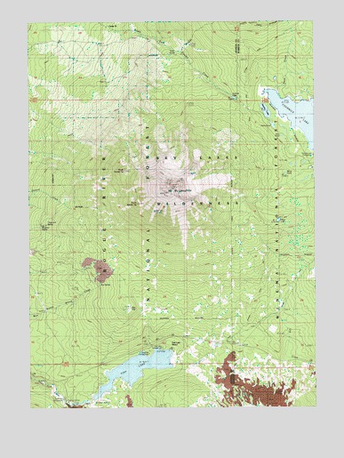
Mount McLoughlin, OR USGS Topographic Map
Click on map above to begin viewing in our Map Viewer.

This topographic map contains these locations and features:
Feature Name Type Latitude Longitude GNIS ID View Map
Blue Rock TrailTrailN42.4907°W122.2803°1138333View Map
Bourbon SpringSpringN42.4334°W122.3708°1138511View Map
Calamity Forest Camp (historical)LocaleN42.4224°W122.2572°1139145View Map
Camp Seventy-sixLocaleN42.4982°W122.3422°1139195View Map
Cold SpringsSpringN42.3888°W122.3737°1155034View Map
Crater TrailTrailN42.4737°W122.3259°1140404View Map
Doe PointCapeN42.3929°W122.3247°1155035View Map
Doe Point Recreation SiteLocaleN42.3926°W122.3239°1926239View Map
Dogwood SpringSpringN42.4343°W122.3683°1141152View Map
Dry Creek CampLocaleN42.4024°W122.2647°1141315View Map
Fish LakeReservoirN42.3877°W122.3293°1142162View Map
Fish Lake DamDamN42.3782°W122.3478°1153917View Map
Fish Lake Recreation SiteLocaleN42.3951°W122.3211°1142166View Map
Fish Lake ResortLocaleN42.3943°W122.3150°1142168View Map
Fish Lake Resort MarinaHarborN42.3934°W122.3153°2699984View Map
Fourmile LakeLakeN42.4669°W122.2543°1161371View Map
Freye LakeLakeN42.4355°W122.2670°1142481View Map
High Lakes PassGapN42.3908°W122.2686°2749454View Map
Medford WatershedAreaN42.4804°W122.3720°1638094View Map
Mirror PondLakeN42.4505°W122.2638°1146354View Map
Mount McLoughlinSummitN42.4445°W122.3160°1146020View Map
Mount McLoughlin TrailTrailN42.4335°W122.2695°1146525View Map
Norris PondLakeN42.4662°W122.2693°1146879View Map
North Fork Recreation SiteLocaleN42.3782°W122.3603°1158394View Map
North Squaw TipSummitN42.4518°W122.3345°1147066View Map
Orris PondLakeN42.4629°W122.2656°1147277View Map
Rye FlatFlatN42.4074°W122.3320°1148877View Map
Rye SpringSpringN42.4149°W122.3453°1148880View Map
South Squaw TipSummitN42.4410°W122.3284°1150085View Map
Squaw LakeLakeN42.4709°W122.2723°1150278View Map
Squaw Tip Trail (historical)TrailN42.4290°W122.3425°1150302View Map
Summit LakeLakeN42.4751°W122.2862°1150621View Map
Summit Sno-ParkLocaleN42.3962°W122.2850°1926284View Map
Swan CreekStreamN42.4768°W122.2678°1161535View Map
Twin PondsReservoirN42.4888°W122.3143°1155402View Map
Twin Ponds CampLocaleN42.4890°W122.3139°1151579View Map
Twin Ponds TrailTrailN42.4732°W122.2831°1151580View Map
Valley of the Rogue DairyLocaleN42.4433°W122.3731°2663777View Map

Note: Coordinates in the location and feature list above are referenced to NAD83 datum.


Copyright (C) 2008-2024 Ryan Niemi / Sunset Dynamics ... All Rights Reserved