TopoQuest Logo
Do you find TopoQuest useful?
Help keep TopoQuest running and adding new maps/features by donating!
Bitcoin:  19c7KJd3qBynnjoSw5npx9KScwjBe4ifkT
Litecoin:  LXs6TkuXGGXo1vDsWCkWVdjQX94eUKd6ui
Home View Maps Find Maps Find Places Resources & Links


Pelican Butte, Oregon Topographic Map

USGS Map Title: Pelican Butte, OR
USGS Map MRC: 42122E2
DRG (GeoTIFF) Download: o42122e2.tif


Neighboring USGS Topographic Map Quads:


  Imnaha Creek, OR  
42122F3
 

  Devils Peak, OR  
42122F2
 

  Mares Egg Spring, OR  
42122F1
 

  Rustler Peak, OR  
42122E3
 

  Pelican Butte, OR  
42122E2
 

  Crystal Spring, OR  
42122E1
 

  Mount McLoughlin, OR  
42122D3
 

  Lake of the Woods North, OR  
42122D2
 

  Pelican Bay, OR  
42122D1


Map MRC Location:

N43°
W123°
N43°
W122°
H8 H7 H6 H5 H4 H3 H2 H1
G8 G7 G6 G5 G4 G3 G2 G1
F8 F7 F6 F5 F4 F3 F2 F1
E8 E7 E6 E5 E4 E3 E2 E1
D8 D7 D6 D5 D4 D3 D2 D1
C8 C7 C6 C5 C4 C3 C2 C1
B8 B7 B6 B5 B4 B3 B2 B1
A8 A7 A6 A5 A4 A3 A2 A1
N42°
W123°
N42°
W122°

Pelican Butte, OR USGS 1:24K Topographic Map Preview:
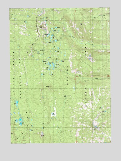
Pelican Butte, OR USGS Topographic Map
Click on map above to begin viewing in our Map Viewer.

This topographic map contains these locations and features:
Feature Name Type Latitude Longitude GNIS ID View Map
Bert LakeLakeN42.5161°W122.2238°1137953View Map
Big MeadowsSwampN42.5273°W122.1953°1138045View Map
Center LakeLakeN42.5122°W122.2262°1139541View Map
Cherry PeakSummitN42.5779°W122.1511°1139601View Map
Cloud Lake GroupLakeN42.5210°W122.1425°1139841View Map
Cold SpringSpringN42.5434°W122.1810°1135020View Map
Cold Spring CampLocaleN42.5429°W122.1811°1139953View Map
Cold Spring TrailTrailN42.5512°W122.1922°1139963View Map
Cold Springs Recreation SiteLocaleN42.5435°W122.1800°1156248View Map
Dee LakeLakeN42.5208°W122.2434°1140782View Map
Deep LakeLakeN42.5735°W122.1940°1158199View Map
Deep LakeLakeN42.6058°W122.1983°1158200View Map
Deer LakeLakeN42.5637°W122.2112°1140852View Map
Donna LakeLakeN42.6039°W122.1963°1141180View Map
Dwarf Lakes AreaAreaN42.5843°W122.2161°1141450View Map
Fly LakeLakeN42.5807°W122.2225°1142274View Map
Heavenly Twin LakesLakeN42.5686°W122.1969°1143440View Map
Hemlock LakeLakeN42.6175°W122.2283°1143480View Map
Hemlock Lake CampgroundLocaleN42.6179°W122.2289°1167052View Map
Holst LakeLakeN42.6124°W122.2307°1143680View Map
Imagination PeakSummitN42.5521°W122.2022°1143997View Map
Isherwood LakeLakeN42.5726°W122.2015°1144132View Map
Island LakeLakeN42.5180°W122.2381°1144135View Map
Island Lake Campground (historical)ParkN42.5235°W122.2372°1162426View Map
Lake ElizabethLakeN42.5695°W122.2016°1141738View Map
Lake FlorenceLakeN42.5748°W122.2081°1154824View Map
Lake FrancisLakeN42.5288°W122.1326°1142408View Map
Lake GladysLakeN42.5320°W122.1377°1142764View Map
Lake HuniceLakeN42.5278°W122.1295°1159013View Map
Lake LandLakeN42.5848°W122.1934°1144807View Map
Lake LizaLakeN42.5733°W122.2051°1145298View Map
Lake No-Se-UmLakeN42.5933°W122.2045°1159014View Map
Lake NotashaLakeN42.5679°W122.2026°1147083View Map
Lake RudenLakeN42.5791°W122.2030°1154823View Map
Lake SonyaLakeN42.5947°W122.1938°1149877View Map
Lather MountainSummitN42.6096°W122.1611°1144855View Map
Lost LakeLakeN42.5141°W122.2115°1145543View Map
Lost PeakSummitN42.5060°W122.2131°1145553View Map
Luther MountainSummitN42.6071°W122.2111°1145687View Map
Margurette LakeLakeN42.5998°W122.2030°1145804View Map
Martin LakeLakeN42.6159°W122.2067°1145847View Map
Mosquito LakeLakeN42.5757°W122.1866°1146498View Map
Nannie Creek TrailTrailN42.6179°W122.1464°1146727View Map
Pelican ButteSummitN42.5132°W122.1459°1147568View Map
Punky LakeLakeN42.5637°W122.1997°1148048View Map
Red LakeLakeN42.5369°W122.2429°1148311View Map
Red Lake Campground (historical)ParkN42.5374°W122.2428°1162425View Map
Red Lake TrailTrailN42.5665°W122.2467°1148314View Map
Sky Lakes AreaAreaN42.5965°W122.1997°1149648View Map
Sky Lakes WildernessReserveN42.6184°W122.2319°2035305View Map
Snow LakesLakeN42.6126°W122.2064°1158490View Map
South Island Campground (historical)ParkN42.5165°W122.2386°1162424View Map
Trapper LakeLakeN42.5984°W122.1986°1151396View Map
Tsuga LakeLakeN42.6093°W122.2045°1151465View Map
White Pine LakeLakeN42.6068°W122.1931°1135019View Map
Wickiup TrailTrailN42.5940°W122.2420°1152313View Map
Wind LakeLakeN42.6146°W122.2089°1152490View Map
Wizzard LakeLakeN42.5878°W122.1908°1152567View Map

Note: Coordinates in the location and feature list above are referenced to NAD83 datum.


Copyright (C) 2008-2024 Ryan Niemi / Sunset Dynamics ... All Rights Reserved