TopoQuest Logo
Do you find TopoQuest useful?
Help keep TopoQuest running and adding new maps/features by donating!
Bitcoin:  19c7KJd3qBynnjoSw5npx9KScwjBe4ifkT
Litecoin:  LXs6TkuXGGXo1vDsWCkWVdjQX94eUKd6ui
Home View Maps Find Maps Find Places Resources & Links


Mount Tom, Minnesota Topographic Map

USGS Map Title: Mount Tom, MN
USGS Map MRC: 45095C1
DRG (GeoTIFF) Download: o45095c1.tif


Neighboring USGS Topographic Map Quads:


  Lake Johanna, MN  
45095D2
 

  Belgrade, MN  
45095D1
 

  Georgeville, MN  
45094D8
 

  Sunburg, MN  
45095C2
 

  Mount Tom, MN  
45095C1
 

  New London, MN  
45094C8
 

  Pennock, MN  
45095B2
 

  Solomon Lake, MN  
45095B1
 

  Spicer, MN  
45094B8


Map MRC Location:

N46°
W96°
N46°
W95°
H8 H7 H6 H5 H4 H3 H2 H1
G8 G7 G6 G5 G4 G3 G2 G1
F8 F7 F6 F5 F4 F3 F2 F1
E8 E7 E6 E5 E4 E3 E2 E1
D8 D7 D6 D5 D4 D3 D2 D1
C8 C7 C6 C5 C4 C3 C2 C1
B8 B7 B6 B5 B4 B3 B2 B1
A8 A7 A6 A5 A4 A3 A2 A1
N45°
W96°
N45°
W95°

Mount Tom, MN USGS 1:24K Topographic Map Preview:
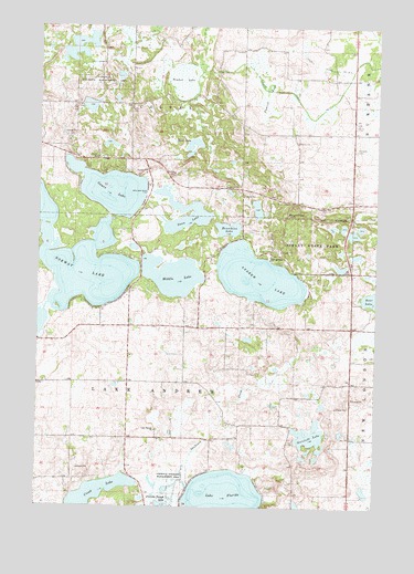
Mount Tom, MN USGS Topographic Map
Click on map above to begin viewing in our Map Viewer.

This topographic map contains these locations and features:
Feature Name Type Latitude Longitude GNIS ID View Map
Andrew LakeLakeN45.3099°W95.0438°639365View Map
Broberg-Lundborg State MonumentParkN45.3278°W95.0194°2067781View Map
Burbank CemeteryCemeteryN45.3434°W95.0084°2067769View Map
Colfax CemeteryCemeteryN45.3541°W95.0909°2067761View Map
County Ditch Number B FourCanalN45.3644°W95.0178°642387View Map
County Ditch Number B ThreeCanalN45.3727°W95.0661°642386View Map
County Ditch Number ThirtysevenCanalN45.3597°W95.0131°642021View Map
Crook LakeLakeN45.2531°W95.1029°642453View Map
Games LakeLakeN45.3323°W95.0987°644020View Map
Henschien LakeLakeN45.3225°W95.0551°644894View Map
Lake Andrew CemeteryCemeteryN45.3008°W95.0100°2067759View Map
Lake FloridaLakeN45.2523°W95.0570°643761View Map
Lake Florida CemeteryCemeteryN45.2699°W95.0808°2067760View Map
Lake Florida ChurchChurchN45.2697°W95.0814°646350View Map
Middle LakeLakeN45.3102°W95.0756°647814View Map
Mount TomSummitN45.3261°W95.0328°653226View Map
Norstedt LakeLakeN45.2682°W95.0245°648603View Map
Norway LakeLakeN45.3204°W95.1213°648750View Map
Prairie LakeSwampN45.3620°W95.0436°649713View Map
Sibley State ParkParkN45.3197°W95.0231°652012View Map
Skull LakeLakeN45.3440°W95.0686°652125View Map
Swan LakeLakeN45.3244°W95.0719°652891View Map
Swedish ChurchChurchN45.3277°W95.0195°652933View Map
Timber LakeSwampN45.3613°W95.0748°653205View Map
Township of ColfaxCivilN45.3690°W95.0704°663846View Map
Township of Lake AndrewCivilN45.2823°W95.0706°664661View Map

Note: Coordinates in the location and feature list above are referenced to NAD83 datum.


Copyright (C) 2008-2025 Ryan Niemi / Sunset Dynamics ... All Rights Reserved