TopoQuest Logo
Do you find TopoQuest useful?
Help keep TopoQuest running and adding new maps/features by donating!
Bitcoin:  19c7KJd3qBynnjoSw5npx9KScwjBe4ifkT
Litecoin:  LXs6TkuXGGXo1vDsWCkWVdjQX94eUKd6ui
Home View Maps Find Maps Find Places Resources & Links


Lake Johanna, Minnesota Topographic Map

USGS Map Title: Lake Johanna, MN
USGS Map MRC: 45095D2
DRG (GeoTIFF) Download: o45095d2.tif


Neighboring USGS Topographic Map Quads:


  Terrace, MN  
45095E3
 

  Sedan, MN  
45095E2
 

  Padua, MN  
45095E1
 

  Lake Simon, MN  
45095D3
 

  Lake Johanna, MN  
45095D2
 

  Belgrade, MN  
45095D1
 

  De Graff SE, MN  
45095C3
 

  Sunburg, MN  
45095C2
 

  Mount Tom, MN  
45095C1


Map MRC Location:

N46°
W96°
N46°
W95°
H8 H7 H6 H5 H4 H3 H2 H1
G8 G7 G6 G5 G4 G3 G2 G1
F8 F7 F6 F5 F4 F3 F2 F1
E8 E7 E6 E5 E4 E3 E2 E1
D8 D7 D6 D5 D4 D3 D2 D1
C8 C7 C6 C5 C4 C3 C2 C1
B8 B7 B6 B5 B4 B3 B2 B1
A8 A7 A6 A5 A4 A3 A2 A1
N45°
W96°
N45°
W95°

Lake Johanna, MN USGS 1:24K Topographic Map Preview:
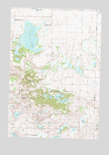
Lake Johanna, MN USGS Topographic Map
Click on map above to begin viewing in our Map Viewer.

This topographic map contains these locations and features:
Feature Name Type Latitude Longitude GNIS ID View Map
Bangor State Wildlife Management AreaParkN45.4980°W95.2178°639617View Map
Brenner LakeLakeN45.3969°W95.2372°640461View Map
County Ditch Number FifteenCanalN45.3844°W95.2411°641702View Map
Crook LakeLakeN45.4148°W95.1998°642452View Map
Grass LakeLakeN45.4270°W95.1307°644385View Map
Kandiyohi County Waterfowl Production AreaParkN45.3818°W95.1646°2765353View Map
Kittleson LakeLakeN45.4554°W95.2415°646184View Map
Kjos PoolReservoirN45.4350°W95.2053°1776344View Map
Lake JohannaLakeN45.4724°W95.2232°645662View Map
Lake Johanna CemeteryCemeteryN45.4558°W95.1940°646367View Map
Leif Langsjoen Waterfowl Development DamDamN45.3933°W95.1453°1776650View Map
Little Jo State Wildlife Management AreaParkN45.4197°W95.1970°646824View Map
Mud Creek Number 5 Group DamDamN45.4350°W95.2053°1776343View Map
Ole LakeLakeN45.3755°W95.1829°648942View Map
Rocky Mountain LakeLakeN45.4152°W95.1811°650212View Map
Round LakeLakeN45.4145°W95.1932°650330View Map
Section Twelve LakeLakeN45.3922°W95.1465°651826View Map
Skanning LakeLakeN45.4110°W95.1746°652112View Map
Skarpness State Wildlife Management AreaParkN45.4872°W95.2492°652113View Map
South Lake Johanna CemeteryCemeteryN45.4204°W95.1724°2066883View Map
South Lake Johanna ChurchChurchN45.4200°W95.1725°652324View Map
Stockholm Family CemeteryCemeteryN45.4111°W95.2333°2067741View Map
Township of Lake JohannaCivilN45.4558°W95.1933°664684View Map
Trinity CemeteryCemeteryN45.4996°W95.1320°653291View Map

Note: Coordinates in the location and feature list above are referenced to NAD83 datum.


Copyright (C) 2008-2025 Ryan Niemi / Sunset Dynamics ... All Rights Reserved