TopoQuest Logo
Do you find TopoQuest useful?
Help keep TopoQuest running and adding new maps/features by donating!
Bitcoin:  19c7KJd3qBynnjoSw5npx9KScwjBe4ifkT
Litecoin:  LXs6TkuXGGXo1vDsWCkWVdjQX94eUKd6ui
Home View Maps Find Maps Find Places Resources & Links


Pennock, Minnesota Topographic Map

USGS Map Title: Pennock, MN
USGS Map MRC: 45095B2
DRG (GeoTIFF) Download: o45095b2.tif


Neighboring USGS Topographic Map Quads:


  De Graff SE, MN  
45095C3
 

  Sunburg, MN  
45095C2
 

  Mount Tom, MN  
45095C1
 

  Kerkhoven, MN  
45095B3
 

  Pennock, MN  
45095B2
 

  Solomon Lake, MN  
45095B1
 

  Kerkhoven SE, MN  
45095A3
 

  Raymond, MN  
45095A2
 

  Willmar, MN  
45095A1


Map MRC Location:

N46°
W96°
N46°
W95°
H8 H7 H6 H5 H4 H3 H2 H1
G8 G7 G6 G5 G4 G3 G2 G1
F8 F7 F6 F5 F4 F3 F2 F1
E8 E7 E6 E5 E4 E3 E2 E1
D8 D7 D6 D5 D4 D3 D2 D1
C8 C7 C6 C5 C4 C3 C2 C1
B8 B7 B6 B5 B4 B3 B2 B1
A8 A7 A6 A5 A4 A3 A2 A1
N45°
W96°
N45°
W95°

Pennock, MN USGS 1:24K Topographic Map Preview:
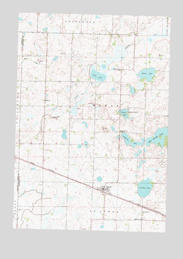
Pennock, MN USGS Topographic Map
Click on map above to begin viewing in our Map Viewer.

This topographic map contains these locations and features:
Feature Name Type Latitude Longitude GNIS ID View Map
Church LakeLakeN45.1930°W95.1613°641216View Map
City of PennockCivilN45.1459°W95.1750°2396177View Map
East ParkParkN45.1483°W95.1717°2067684View Map
Lindgren LakeLakeN45.1785°W95.1588°646715View Map
Mamre LakeLakeN45.2163°W95.1430°647427View Map
Mamre Lund ChurchChurchN45.1936°W95.1575°647428View Map
Mamrelund Lutheran CemeteryCemeteryN45.1938°W95.1584°2067754View Map
Mamrelund Lutheran ChurchChurchN45.1497°W95.1733°2067686View Map
PennockLocaleN45.1486°W95.1772°2067780View Map
PennockPopulated PlaceN45.1489°W95.1764°649266View Map
Pennock Fire DepartmentBuildingN45.1492°W95.1778°2666369View Map
Pennock Post OfficePost OfficeN45.1492°W95.1772°2067779View Map
Saint John's CemeteryCemeteryN45.1358°W95.1439°2067753View Map
Saint Johns ChurchChurchN45.1358°W95.1439°650712View Map
Saint Johns LakeLakeN45.1501°W95.1432°650727View Map
Salem CemeteryCemeteryN45.1968°W95.1434°2067755View Map
Salem ChurchChurchN45.2000°W95.2259°651101View Map
School Number 761 NSchoolN45.2183°W95.1645°651729View Map
School Number 761 SSchoolN45.1825°W95.1645°651730View Map
School Number 780SchoolN45.1322°W95.1442°651736View Map
South ParkParkN45.1472°W95.1753°2067683View Map
Swan LakeLakeN45.2168°W95.1814°652889View Map
Swan LakeReservoirN45.2083°W95.1853°1776655View Map
Swan Lake Watershed Structure DamDamN45.2083°W95.1853°1776654View Map
Township of MamreCivilN45.1958°W95.1854°664883View Map
West ParkParkN45.1500°W95.1806°2067685View Map
Youngren Dairy FarmsLocaleN45.2189°W95.1994°2674659View Map

Note: Coordinates in the location and feature list above are referenced to NAD83 datum.


Copyright (C) 2008-2024 Ryan Niemi / Sunset Dynamics ... All Rights Reserved