TopoQuest Logo
Do you find TopoQuest useful?
Help keep TopoQuest running and adding new maps/features by donating!
Bitcoin:  19c7KJd3qBynnjoSw5npx9KScwjBe4ifkT
Litecoin:  LXs6TkuXGGXo1vDsWCkWVdjQX94eUKd6ui
Home View Maps Find Maps Find Places Resources & Links


Mount Washington, Kentucky Topographic Map

USGS Map Title: Mount Washington, KY
USGS Map MRC: 38085A5
DRG (GeoTIFF) Download: o38085a5.tif


Neighboring USGS Topographic Map Quads:


  Louisville East, KY  
38085B6
 

  Jeffersontown, KY  
38085B5
 

  Fisherville, KY  
38085B4
 

  Brooks, KY  
38085A6
 

  Mount Washington, KY  
38085A5
 

  Waterford, KY  
38085A4
 

  Shepherdsville, KY  
37085H6
 

  Samuels, KY  
37085H5
 

  Fairfield, KY  
37085H4


Map MRC Location:

N39°
W86°
N39°
W85°
H8 H7 H6 H5 H4 H3 H2 H1
G8 G7 G6 G5 G4 G3 G2 G1
F8 F7 F6 F5 F4 F3 F2 F1
E8 E7 E6 E5 E4 E3 E2 E1
D8 D7 D6 D5 D4 D3 D2 D1
C8 C7 C6 C5 C4 C3 C2 C1
B8 B7 B6 B5 B4 B3 B2 B1
A8 A7 A6 A5 A4 A3 A2 A1
N38°
W86°
N38°
W85°

Mount Washington, KY USGS 1:24K Topographic Map Preview:
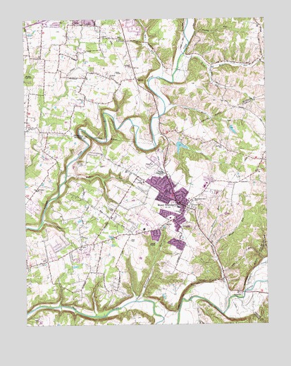
Mount Washington, KY USGS Topographic Map
Click on map above to begin viewing in our Map Viewer.

This topographic map contains these locations and features:
Feature Name Type Latitude Longitude GNIS ID View Map
Back RunStreamN38.1045°W85.5283°486179View Map
Bardstown and Louisville Turnpike Historical MarkerParkN38.0498°W85.5458°2744046View Map
Bethel BranchStreamN38.0415°W85.6166°486947View Map
Bethel ChurchChurchN38.0317°W85.5950°486987View Map
Big RunStreamN38.1012°W85.5525°487243View Map
Broad RunStreamN38.1103°W85.5413°487933View Map
Bull BranchStreamN38.0251°W85.5008°488347View Map
Cedar Creek Wastewater Treatment PlantLocaleN38.1193°W85.5927°2460231View Map
City of Heritage CreekCivilN38.0952°W85.6125°2404687View Map
City of Heritage Creek Police DepartmentBuildingN38.0950°W85.6153°2767729View Map
City of Mount WashingtonCivilN38.0428°W85.5551°2404327View Map
Dutchman CreekStreamN38.0134°W85.5116°491363View Map
FairmountPopulated PlaceN38.1165°W85.5708°491887View Map
Fairmount CemeteryCemeteryN38.1051°W85.5691°491888View Map
Fairmount ChurchChurchN38.1020°W85.5802°491890View Map
Fern Creek Fire Department Station 2BuildingN38.1042°W85.5667°2636628View Map
Gentey CemeteryCemeteryN38.0556°W85.6186°492773View Map
Hays SpringSpringN38.0951°W85.5646°2743863View Map
Hell CemeteryCemeteryN38.0412°W85.5519°494006View Map
Highland Memorial GardensCemeteryN38.0621°W85.5553°494215View Map
Highview Fire Department Station 3BuildingN38.0860°W85.6237°2637212View Map
Hough RunStreamN38.0317°W85.5275°494632View Map
Jefferson Sportsmans Club LakeReservoirN38.0728°W85.5444°2742434View Map
Jones CemeteryCemeteryN38.0020°W85.6183°495481View Map
Lovvorn (historical)Populated PlaceN38.1043°W85.6138°2743864View Map
Lovvorn SchoolSchoolN38.1037°W85.6141°497228View Map
Markwell CemeteryCemeteryN38.0728°W85.5224°497552View Map
McCullough RunStreamN38.0101°W85.5686°497829View Map
Mount WashingtonPopulated PlaceN38.0501°W85.5458°498905View Map
Mount Washington CemeteryCemeteryN38.0503°W85.5380°498907View Map
Mount Washington DivisionCivilN38.0439°W85.5612°1937160View Map
Mount Washington Fire DepartmentBuildingN38.0553°W85.5483°2636572View Map
Mount Washington Police DepartmentBuildingN38.0633°W85.5528°2767781View Map
Mount Washington Post OfficePost OfficeN38.0553°W85.5490°2460359View Map
Mulberry RunStreamN38.0345°W85.5302°499073View Map
Oak Grove ChurchChurchN38.0923°W85.5936°499690View Map
Old Mans RunStreamN38.0862°W85.5519°499855View Map
Old Mill Elementary SchoolSchoolN38.0564°W85.5319°2460719View Map
Owens CemeteryCemeteryN38.0467°W85.5800°500070View Map
Perkins CemeteryCemeteryN38.0401°W85.5438°500414View Map
Pleasant Grove Elementary SchoolSchoolN38.0392°W85.5633°2460725View Map
Saint Francis CemeteryCemeteryN38.0487°W85.5394°502618View Map
Showalter CemeteryCemeteryN38.0459°W85.5433°503462View Map
SmithvillePopulated PlaceN38.0131°W85.5141°517326View Map
Solid Rock Church of GodChurchN38.1202°W85.6152°2460540View Map
South Jefferson DivisionCivilN38.1012°W85.6211°2583526View Map
ThixtonPopulated PlaceN38.1006°W85.5655°505151View Map
Thixton Lane ChurchChurchN38.0798°W85.6233°505152View Map
Turkey RunStreamN38.1151°W85.5380°505628View Map
Wells RunStreamN38.0615°W85.6030°506384View Map
Wheelers RunStreamN38.1076°W85.5019°506541View Map
Whittaker RunStreamN38.0056°W85.5216°506699View Map

Note: Coordinates in the location and feature list above are referenced to NAD83 datum.


Copyright (C) 2008-2025 Ryan Niemi / Sunset Dynamics ... All Rights Reserved