TopoQuest Logo
Do you find TopoQuest useful?
Help keep TopoQuest running and adding new maps/features by donating!
Bitcoin:  19c7KJd3qBynnjoSw5npx9KScwjBe4ifkT
Litecoin:  LXs6TkuXGGXo1vDsWCkWVdjQX94eUKd6ui
Home View Maps Find Maps Find Places Resources & Links


Fisherville, Kentucky Topographic Map

USGS Map Title: Fisherville, KY
USGS Map MRC: 38085B4
DRG (GeoTIFF) Download: o38085b4.tif


Neighboring USGS Topographic Map Quads:


  Anchorage, KY  
38085C5
 

  Crestwood, KY  
38085C4
 

  Ballardsville, KY  
38085C3
 

  Jeffersontown, KY  
38085B5
 

  Fisherville, KY  
38085B4
 

  Simpsonville, KY  
38085B3
 

  Mount Washington, KY  
38085A5
 

  Waterford, KY  
38085A4
 

  Taylorsville, KY  
38085A3


Map MRC Location:

N39°
W86°
N39°
W85°
H8 H7 H6 H5 H4 H3 H2 H1
G8 G7 G6 G5 G4 G3 G2 G1
F8 F7 F6 F5 F4 F3 F2 F1
E8 E7 E6 E5 E4 E3 E2 E1
D8 D7 D6 D5 D4 D3 D2 D1
C8 C7 C6 C5 C4 C3 C2 C1
B8 B7 B6 B5 B4 B3 B2 B1
A8 A7 A6 A5 A4 A3 A2 A1
N38°
W86°
N38°
W85°

Fisherville, KY USGS 1:24K Topographic Map Preview:
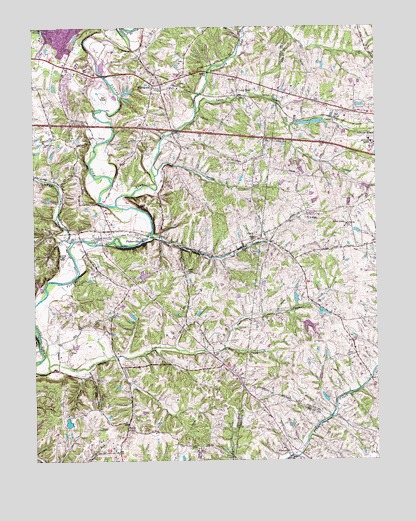
Fisherville, KY USGS Topographic Map
Click on map above to begin viewing in our Map Viewer.

This topographic map contains these locations and features:
Feature Name Type Latitude Longitude GNIS ID View Map
Ascension Lutheran ChurchChurchN38.2416°W85.4971°2459978View Map
Bethlehem Cumberland Presbyterian Church (historical)ChurchN38.1478°W85.4244°487032View Map
Big Long RunStreamN38.2108°W85.3914°2567177View Map
BostonPopulated PlaceN38.2373°W85.4352°507560View Map
Brentlawn Race Course (historical)ParkN38.2290°W85.4097°2567180View Map
Brush RunStreamN38.1901°W85.4566°488095View Map
Brush RunStreamN38.2362°W85.4733°488098View Map
Camp Dan BeardLocaleN38.2487°W85.4780°488693View Map
Cane RunStreamN38.1528°W85.4950°488794View Map
Chenoweth RunStreamN38.2467°W85.4734°489392View Map
ClarkPopulated PlaceN38.1887°W85.4187°2651852View Map
Clark Railroad Station (historical)LocaleN38.1893°W85.4190°2651625View Map
Clark Railroad Station (historical)LocaleN38.1914°W85.4121°2567193View Map
ConnerPopulated PlaceN38.2237°W85.3902°507746View Map
Dunbar BranchStreamN38.1576°W85.4491°491285View Map
East Fork Cane RunStreamN38.1576°W85.4305°491443View Map
EastwoodPopulated PlaceN38.2331°W85.4558°491524View Map
Eastwood Christian ChurchChurchN38.2348°W85.4472°2459797View Map
Eastwood Fire Department Station 1BuildingN38.2335°W85.4571°2636346View Map
Eastwood Fire Department Station 2BuildingN38.1911°W85.4650°2636333View Map
Faith United Church of ChristChurchN38.2400°W85.4914°2459815View Map
Fern Creek Fire Department Station 3BuildingN38.1271°W85.4700°2637210View Map
First Baptist Church of EastwoodChurchN38.2322°W85.4538°2459824View Map
FishervillePopulated PlaceN38.1898°W85.4630°492125View Map
Fisherville Division (historical)CensusN38.1590°W85.4811°1937000View Map
Fisherville Post OfficePost OfficeN38.1889°W85.4607°2460345View Map
Floyds Fork DivisionCivilN38.1587°W85.4850°2583512View Map
Floyds Fork Post Office (historical)Post OfficeN38.2257°W85.4083°2567214View Map
Floyds Fork Railroad Station (historical)LocaleN38.2255°W85.4081°2567215View Map
Floyds Fork Wastewater Treatment PlantLocaleN38.2237°W85.4698°2460243View Map
Greater Life Apostolic ChurchChurchN38.2391°W85.4879°2459877View Map
Humes Station (historical)LocaleN38.2308°W85.4069°2567226View Map
L S ParkPopulated PlaceN38.1956°W85.3997°508412View Map
Lakewood Baptist ChurchChurchN38.2413°W85.4954°2460595View Map
Lincoln RidgePopulated PlaceN38.2184°W85.3752°513432View Map
Lincoln Ridge Post Office (historical)Post OfficeN38.2033°W85.3754°2567230View Map
Long RunStreamN38.1986°W85.4698°497142View Map
Long RunPopulated PlaceN38.2317°W85.4241°508501View Map
Long Run HillSummitN38.2443°W85.4178°2743839View Map
New EastwoodPopulated PlaceN38.2328°W85.4502°2743841View Map
Old EastwoodPopulated PlaceN38.2368°W85.4617°2743842View Map
Pauls CreekStreamN38.2099°W85.4477°2743848View Map
Pope LickStreamN38.1882°W85.4856°501089View Map
Poplar Level ChurchChurchN38.2170°W85.4961°501120View Map
Reformed Baptist Church of LouisvilleChurchN38.1889°W85.4896°2460440View Map
Resurrection United Methodist ChurchChurchN38.2321°W85.4517°2460443View Map
RouttPopulated PlaceN38.1342°W85.4666°508981View Map
Saint Lukes ChurchChurchN38.2348°W85.4247°502676View Map
Shakes RunStreamN38.2070°W85.4552°503234View Map
Sheckels RunStreamN38.1553°W85.4700°503302View Map
South Long RunStreamN38.2253°W85.4394°503961View Map
Whitney M. Young Jr. Residential Manpower CenterSchoolN38.2159°W85.3755°496553View Map
WilsonvillePopulated PlaceN38.1273°W85.4069°506918View Map
Wilsonville Post Office (historical)Post OfficeN38.1259°W85.4063°2567925View Map
WLSY-FM (Jeffersontown)TowerN38.1845°W85.4991°517965View Map

Note: Coordinates in the location and feature list above are referenced to NAD83 datum.


Copyright (C) 2008-2024 Ryan Niemi / Sunset Dynamics ... All Rights Reserved