TopoQuest Logo
Do you find TopoQuest useful?
Help keep TopoQuest running and adding new maps/features by donating!
Bitcoin:  19c7KJd3qBynnjoSw5npx9KScwjBe4ifkT
Litecoin:  LXs6TkuXGGXo1vDsWCkWVdjQX94eUKd6ui
Home View Maps Find Maps Find Places Resources & Links


Mountain Home East, Arkansas Topographic Map

USGS Map Title: Mountain Home East, AR
USGS Map MRC: 36092C3
DRG (GeoTIFF) Download: o36092c3.tif


Neighboring USGS Topographic Map Quads:


  Midway, AR  
36092D4
 

  Clarkridge, AR  
36092D3
 

  Gamaliel, AR  
36092D2
 

  Mountain Home West, AR  
36092C4
 

  Mountain Home East, AR  
36092C3
 

  Norfork Dam North, AR  
36092C2
 

  Buffalo City, AR  
36092B4
 

  Norfork, AR  
36092B3
 

  Norfork Dam South, AR  
36092B2


Map MRC Location:

N37°
W93°
N37°
W92°
H8 H7 H6 H5 H4 H3 H2 H1
G8 G7 G6 G5 G4 G3 G2 G1
F8 F7 F6 F5 F4 F3 F2 F1
E8 E7 E6 E5 E4 E3 E2 E1
D8 D7 D6 D5 D4 D3 D2 D1
C8 C7 C6 C5 C4 C3 C2 C1
B8 B7 B6 B5 B4 B3 B2 B1
A8 A7 A6 A5 A4 A3 A2 A1
N36°
W93°
N36°
W92°

Mountain Home East, AR USGS 1:24K Topographic Map Preview:
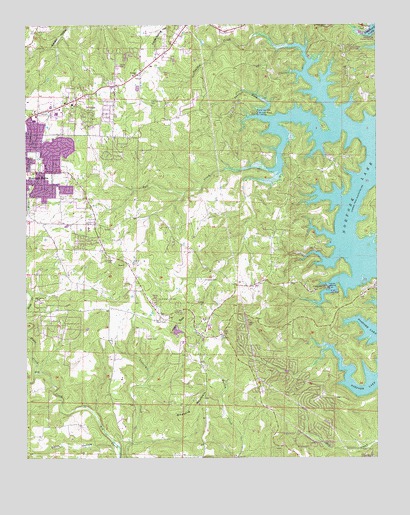
Mountain Home East, AR USGS Topographic Map
Click on map above to begin viewing in our Map Viewer.

This topographic map contains these locations and features:
Feature Name Type Latitude Longitude GNIS ID View Map
Baxter CountyCivilN36.2872°W92.3370°69895View Map
Birdsong MountainSummitN36.2678°W92.3127°57381View Map
BriarcliffPopulated PlaceN36.2751°W92.2863°69346View Map
Buzzard Roose Use AreaParkN36.3501°W92.2927°69348View Map
Buzzard Roost LandingLocaleN36.3498°W92.2921°57484View Map
City of BriarcliffCivilN36.2717°W92.2821°2403922View Map
Douglas CemeteryCemeteryN36.3014°W92.3071°48585View Map
East Oakland Baptist ChurchChurchN36.3606°W92.3352°77890View Map
East Oakland CemeteryCemeteryN36.3603°W92.3352°69365View Map
Fall CreekStreamN36.3470°W92.2854°48993View Map
Fellowship Cumberland Presbyterian ChurchChurchN36.3328°W92.3640°69369View Map
Heart BaldSummitN36.2887°W92.3215°49980View Map
Heart CemeteryCemeteryN36.2901°W92.3263°49981View Map
Heritage EstatesPopulated PlaceN36.2903°W92.3652°69384View Map
Hicks CreekStreamN36.2851°W92.3749°50089View Map
Mountain Home Fire Department Station 2BuildingN36.3543°W92.3580°2116830View Map
Northeast Lakeside Volunteer Fire DepartmentBuildingN36.3735°W92.3035°2116877View Map
Oak Grove CemeteryCemeteryN36.2959°W92.3702°69421View Map
Oak Grove ChurchChurchN36.2959°W92.3707°52918View Map
Oakland School (historical)SchoolN36.3612°W92.3352°69422View Map
Old Oakland CemeteryCemeteryN36.3531°W92.3307°53010View Map
Panther Bay Public Use AreaParkN36.3715°W92.2515°69424View Map
Panther CreekStreamN36.3584°W92.2724°53152View Map
Panther ForkStreamN36.3476°W92.2879°53165View Map
Shoal CreekStreamN36.2817°W92.2674°69439View Map
Smith HollowValleyN36.2515°W92.3424°54953View Map
Sycamore HeightsPopulated PlaceN36.2856°W92.2654°69443View Map
Township of Mountain HomeCivilN36.3347°W92.3688°69566View Map
Traceys Ferry (historical)CrossingN36.3051°W92.2557°69449View Map
Traceys Ford (historical)CrossingN36.3051°W92.2557°69450View Map
Traceys LandingLocaleN36.2990°W92.2668°58756View Map
Tracy Area Volunteer Fire DepartmentBuildingN36.2844°W92.3132°2117218View Map
Tracy Use AreaParkN36.2992°W92.2682°69451View Map
Village Mall Shopping CenterLocaleN36.3481°W92.3718°69455View Map

Note: Coordinates in the location and feature list above are referenced to NAD83 datum.


Copyright (C) 2008-2024 Ryan Niemi / Sunset Dynamics ... All Rights Reserved