TopoQuest Logo
Do you find TopoQuest useful?
Help keep TopoQuest running and adding new maps/features by donating!
Bitcoin:  19c7KJd3qBynnjoSw5npx9KScwjBe4ifkT
Litecoin:  LXs6TkuXGGXo1vDsWCkWVdjQX94eUKd6ui
Home View Maps Find Maps Find Places Resources & Links


Buffalo City, Arkansas Topographic Map

USGS Map Title: Buffalo City, AR
USGS Map MRC: 36092B4
DRG (GeoTIFF) Download: o36092b4.tif


Neighboring USGS Topographic Map Quads:


  Cotter, AR  
36092C5
 

  Mountain Home West, AR  
36092C4
 

  Mountain Home East, AR  
36092C3
 

  Rea Valley, AR  
36092B5
 

  Buffalo City, AR  
36092B4
 

  Norfork, AR  
36092B3
 

  Cozahome, AR  
36092A5
 

  Big Flat, AR  
36092A4
 

  Norfork SE, AR  
36092A3


Map MRC Location:

N37°
W93°
N37°
W92°
H8 H7 H6 H5 H4 H3 H2 H1
G8 G7 G6 G5 G4 G3 G2 G1
F8 F7 F6 F5 F4 F3 F2 F1
E8 E7 E6 E5 E4 E3 E2 E1
D8 D7 D6 D5 D4 D3 D2 D1
C8 C7 C6 C5 C4 C3 C2 C1
B8 B7 B6 B5 B4 B3 B2 B1
A8 A7 A6 A5 A4 A3 A2 A1
N36°
W93°
N36°
W92°

Buffalo City, AR USGS 1:24K Topographic Map Preview:
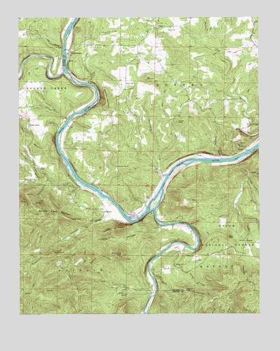
Buffalo City, AR USGS Topographic Map
Click on map above to begin viewing in our Map Viewer.

This topographic map contains these locations and features:
Feature Name Type Latitude Longitude GNIS ID View Map
AdvancePopulated PlaceN36.1553°W92.3824°70414View Map
Birds FordCrossingN36.1537°W92.4129°70045View Map
Brush CreekStreamN36.1251°W92.4338°70854View Map
Buffalo CityPopulated PlaceN36.1678°W92.4421°76459View Map
Buffalo LandingLocaleN36.1740°W92.4563°70049View Map
Buffalo National River WildernessReserveN36.1260°W92.4655°2035072View Map
Buffalo RiverStreamN36.1781°W92.4260°81847View Map
BufordPopulated PlaceN36.2456°W92.4285°70915View Map
Buford School (historical)SchoolN36.2459°W92.4277°69347View Map
Buford StationLocaleN36.2351°W92.4743°70916View Map
Buford Volunteer Fire DepartmentBuildingN36.2487°W92.4275°2116203View Map
Campbells ShoalBarN36.1498°W92.4279°70050View Map
CartneyPopulated PlaceN36.1945°W92.3824°71023View Map
Cleveland KnobSummitN36.1348°W92.4141°71168View Map
Cockran CreekStreamN36.1845°W92.3802°71178View Map
Cook HollowValleyN36.1623°W92.4265°76663View Map
Cow CreekStreamN36.1334°W92.4299°71255View Map
Cow Rock ShoalsBarN36.1403°W92.4307°70054View Map
Crooked CreekStreamN36.2273°W92.4768°71283View Map
Crystal PointCliffN36.1653°W92.4732°71304View Map
Cunningham CreekStreamN36.1837°W92.4229°71317View Map
Dry CreekStreamN36.2223°W92.4643°71441View Map
Elm HollowValleyN36.2376°W92.4776°71554View Map
Fletcher MountainSummitN36.2137°W92.4549°71638View Map
Fox Den SpringSpringN36.1340°W92.4471°71674View Map
Gin EddyBayN36.1628°W92.4204°70060View Map
Goodmans FordCrossingN36.1631°W92.4185°70061View Map
Gosha CreekStreamN36.1406°W92.4304°71791View Map
Granite MountainSummitN36.1501°W92.4582°71798View Map
Hand MountainSummitN36.1951°W92.4910°71893View Map
Hand ValleyPopulated PlaceN36.2051°W92.4946°71894View Map
Haskell CemeteryCemeteryN36.2223°W92.4404°71933View Map
Hathaway HollowValleyN36.1664°W92.4532°71935View Map
Hathaway MountainSummitN36.1501°W92.4838°71936View Map
Hip MountainSummitN36.2248°W92.4343°72024View Map
Holsey HollowValleyN36.1440°W92.4160°72050View Map
Hoodlum RidgeRidgeN36.1942°W92.4999°72059View Map
Hudsons BendBendN36.1537°W92.4077°70063View Map
Laffoon CreekStreamN36.1637°W92.4418°70064View Map
Laytonville (historical)Populated PlaceN36.2103°W92.4418°69395View Map
Lion HillSummitN36.1759°W92.4968°72359View Map
Lone RockCliffN36.1928°W92.3765°72460View Map
Mountain View ChurchChurchN36.1873°W92.4490°72798View Map
Nelson CemeteryCemeteryN36.2448°W92.4227°72845View Map
Nelson CreekStreamN36.1903°W92.3940°72846View Map
Nelsons Ferry (historical)CrossingN36.1898°W92.3946°69410View Map
Old BuffaloPopulated PlaceN36.1684°W92.4568°77901View Map
Perry CreekStreamN36.1915°W92.3829°77978View Map
Perry KnobSummitN36.1575°W92.3914°73046View Map
Prince Fred KnobSummitN36.1498°W92.4471°73203View Map
Running ForkStreamN36.1812°W92.4863°73437View Map
Shields ChuteChannelN36.1259°W92.4357°70071View Map
Stair BluffCliffN36.1634°W92.4390°73688View Map
Steep GullyValleyN36.1946°W92.3751°73694View Map
Stewart CreekStreamN36.1534°W92.4138°73705View Map
Terrapin CreekStreamN36.1651°W92.3838°73842View Map
Tinnan Rock ShoalsBarN36.1323°W92.4318°70076View Map
Township of Buffalo (historical)CivilN36.1487°W92.4710°69628View Map
Township of BufordCivilN36.2272°W92.4150°69558View Map
Township of MatneyCivilN36.1416°W92.3828°69564View Map
Trimble HollowValleyN36.1837°W92.3807°73893View Map
Turkey KnobSummitN36.2062°W92.4171°73906View Map
Turkey MountainSummitN36.1612°W92.4488°73907View Map
Warner CreekStreamN36.1792°W92.4660°74006View Map
Warrior CreekStreamN36.1815°W92.4893°74010View Map
Warrior Creek MountainSummitN36.1673°W92.4802°74011View Map
Williams CreekStreamN36.1823°W92.4846°74161View Map

Note: Coordinates in the location and feature list above are referenced to NAD83 datum.


Copyright (C) 2008-2025 Ryan Niemi / Sunset Dynamics ... All Rights Reserved