TopoQuest Logo
Do you find TopoQuest useful?
Help keep TopoQuest running and adding new maps/features by donating!
Bitcoin:  19c7KJd3qBynnjoSw5npx9KScwjBe4ifkT
Litecoin:  LXs6TkuXGGXo1vDsWCkWVdjQX94eUKd6ui
Home View Maps Find Maps Find Places Resources & Links


Jessieville, Arkansas Topographic Map

USGS Map Title: Jessieville, AR
USGS Map MRC: 34093F1
DRG (GeoTIFF) Download: o34093f1.tif


Neighboring USGS Topographic Map Quads:


  Nimrod SW, AR  
34093G2
 

  Nimrod SE, AR  
34093G1
 

  Paron SW, AR  
34092G8
 

  Hamilton, AR  
34093F2
 

  Jessieville, AR  
34093F1
 

  Goosepond Mountain, AR  
34092F8
 

  Mountain Pine, AR  
34093E2
 

  Hot Springs North, AR  
34093E1
 

  Fountain Lake, AR  
34092E8


Map MRC Location:

N35°
W94°
N35°
W93°
H8 H7 H6 H5 H4 H3 H2 H1
G8 G7 G6 G5 G4 G3 G2 G1
F8 F7 F6 F5 F4 F3 F2 F1
E8 E7 E6 E5 E4 E3 E2 E1
D8 D7 D6 D5 D4 D3 D2 D1
C8 C7 C6 C5 C4 C3 C2 C1
B8 B7 B6 B5 B4 B3 B2 B1
A8 A7 A6 A5 A4 A3 A2 A1
N34°
W94°
N34°
W93°

Jessieville, AR USGS 1:24K Topographic Map Preview:
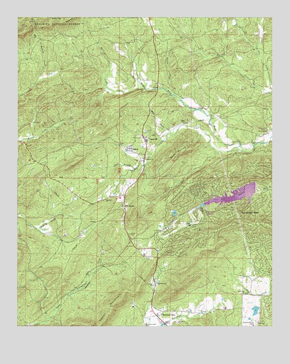
Jessieville, AR USGS Topographic Map
Click on map above to begin viewing in our Map Viewer.

This topographic map contains these locations and features:
Feature Name Type Latitude Longitude GNIS ID View Map
Baily BranchStreamN34.7031°W93.0502°70489View Map
Bethlehem ChurchChurchN34.6762°W93.0821°70645View Map
Big LakeReservoirN34.6314°W93.0085°80357View Map
Big Lake DamDamN34.6334°W93.0085°80356View Map
BlakelyPopulated PlaceN34.6968°W93.0693°70710View Map
Blue SpringsPopulated PlaceN34.6737°W93.0730°70737View Map
Brook Hill Ranch CampLocaleN34.6254°W93.0096°70831View Map
Buffalo GapGapN34.7493°W93.1057°70913View Map
Cedar MountainRidgeN34.6256°W93.0843°71092View Map
Cedar Mountain ChurchChurchN34.6423°W93.0571°71094View Map
Coleman CreekStreamN34.6973°W93.0168°71196View Map
Cosby CemeteryCemeteryN34.7076°W93.0432°71234View Map
Cub CreekStreamN34.7204°W93.0005°71310View Map
De Soto Golf CourseLocaleN34.6665°W93.0421°64303View Map
Glazier Peau ChurchChurchN34.6379°W93.0146°71765View Map
Gross LakeReservoirN34.6484°W93.0918°81008View Map
Gross Lake DamDamN34.6484°W93.0918°81007View Map
Hot Springs Dam Number OneDamN34.6818°W93.0085°80350View Map
Hot Springs Dam Number TwoDamN34.6701°W93.0468°80352View Map
Hot Springs Village Emergency Medical ServicesBuildingN34.6732°W93.0317°2119069View Map
Hot Springs Village Fire Department Desoto StationBuildingN34.6738°W93.0334°2116604View Map
Hot Springs Village Police DepartmentBuildingN34.6738°W93.0333°2118810View Map
JessievillePopulated PlaceN34.7012°W93.0616°72184View Map
Jessieville ChurchChurchN34.6926°W93.0630°72185View Map
Jessieville Elementary SchoolSchoolN34.7011°W93.0623°64320View Map
Jessieville Fire Department Station 1BuildingN34.6930°W93.0644°2116634View Map
Jessieville High SchoolSchoolN34.7005°W93.0615°64321View Map
Jessieville Post OfficePost OfficeN34.7006°W93.0632°2781868View Map
Jessieville Work CenterLocaleN34.7043°W93.0624°74468View Map
KALR-FM (Hot Springs)TowerN34.6254°W93.0105°85195View Map
Lake DesotoReservoirN34.6782°W93.0181°80351View Map
Lake SegoviaReservoirN34.6711°W93.0484°80353View Map
Lena (historical)Populated PlaceN34.7076°W93.1163°64327View Map
Merriott CreekStreamN34.7212°W93.0649°72628View Map
Mountain ValleyPopulated PlaceN34.6293°W93.0568°72793View Map
Mountain Valley CemeteryCemeteryN34.6251°W93.0627°72794View Map
Mountain Valley ChurchChurchN34.6251°W93.0518°52499View Map
Newkirk CemeteryCemeteryN34.7031°W93.0032°72863View Map
Poison CreekStreamN34.7190°W93.0485°73148View Map
Shiloh CemeteryCemeteryN34.6623°W93.0705°73542View Map
Short MountainSummitN34.6962°W93.0438°73571View Map
Still BranchStreamN34.6904°W93.0630°73707View Map
Township of Jessieville (historical)CivilN34.7056°W93.0668°66593View Map
Township of Marble (historical)CivilN34.7459°W93.0030°64331View Map
Township of Mountain Valley (historical)CivilN34.6279°W93.0668°64338View Map
Township of Wood (historical)CivilN34.6834°W93.0752°64360View Map

Note: Coordinates in the location and feature list above are referenced to NAD83 datum.


Copyright (C) 2008-2025 Ryan Niemi / Sunset Dynamics ... All Rights Reserved