TopoQuest Logo
Do you find TopoQuest useful?
Help keep TopoQuest running and adding new maps/features by donating!
Bitcoin:  19c7KJd3qBynnjoSw5npx9KScwjBe4ifkT
Litecoin:  LXs6TkuXGGXo1vDsWCkWVdjQX94eUKd6ui
Home View Maps Find Maps Find Places Resources & Links


Mouth of Wilson, Virginia Topographic Map

USGS Map Title: Mouth of Wilson, VA
USGS Map MRC: 36081E3
DRG (GeoTIFF) Download: o36081e3.tif


Neighboring USGS Topographic Map Quads:


  Trout Dale, VA  
36081F4
 

  Middle Fox Creek, VA  
36081F3
 

  Elk Creek, VA  
36081F2
 

  Grassy Creek, NC  
36081E4
 

  Mouth of Wilson, VA  
36081E3
 

  Sparta West, NC  
36081E2
 

  Jefferson, NC  
36081D4
 

  Laurel Springs, NC  
36081D3
 

  Whitehead, NC  
36081D2


Map MRC Location:

N37°
W82°
N37°
W81°
H8 H7 H6 H5 H4 H3 H2 H1
G8 G7 G6 G5 G4 G3 G2 G1
F8 F7 F6 F5 F4 F3 F2 F1
E8 E7 E6 E5 E4 E3 E2 E1
D8 D7 D6 D5 D4 D3 D2 D1
C8 C7 C6 C5 C4 C3 C2 C1
B8 B7 B6 B5 B4 B3 B2 B1
A8 A7 A6 A5 A4 A3 A2 A1
N36°
W82°
N36°
W81°

Mouth of Wilson, VA USGS 1:24K Topographic Map Preview:
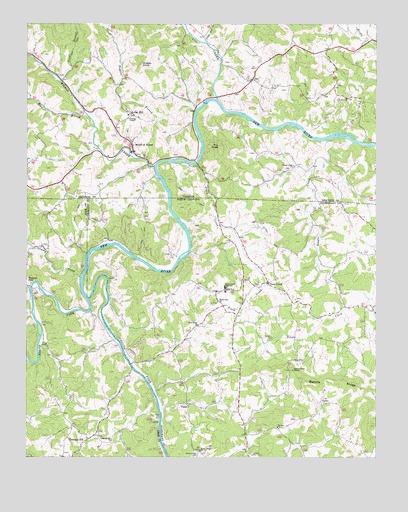
Mouth of Wilson, VA USGS Topographic Map
Click on map above to begin viewing in our Map Viewer.

This topographic map contains these locations and features:
Feature Name Type Latitude Longitude GNIS ID View Map
Anderson FordCrossingN36.5948°W81.2879°1501149View Map
Bakers RidgeRidgeN36.5218°W81.2645°980456View Map
Bakers Ridge MissionChurchN36.5257°W81.2795°980457View Map
Bear BranchStreamN36.5987°W81.3532°1481508View Map
Chestnut HillPopulated PlaceN36.5054°W81.3523°1019628View Map
Chestnut Hill ChurchChurchN36.5051°W81.3440°983110View Map
Fields DamDamN36.6035°W81.3115°1489913View Map
Fields ReservoirReservoirN36.6035°W81.3115°1489914View Map
FoxPopulated PlaceN36.6093°W81.2934°1477339View Map
Fox CreekStreamN36.6035°W81.3065°1483513View Map
Fox KnobSummitN36.5901°W81.3059°1466828View Map
Fox Union Baptist ChurchChurchN36.6090°W81.2945°1501189View Map
Fox Union CemeteryCemeteryN36.6098°W81.2957°1501190View Map
Gold Hill CemeteryCemeteryN36.6037°W81.2601°1501193View Map
Gold Hill ChurchChurchN36.6040°W81.2604°1467187View Map
Gold Hill School (historical)SchoolN36.6037°W81.2607°1501195View Map
Grassy CreekStreamN36.5523°W81.3557°985955View Map
Grassy KnobSummitN36.6132°W81.3334°1495608View Map
Halsey Ferry (historical)CrossingN36.5857°W81.3240°1501201View Map
Hash Mill (historical)LocaleN36.5557°W81.2707°1959888View Map
Irwin Mill (historical)LocaleN36.5496°W81.2898°1959892View Map
Jacks BottomFlatN36.5426°W81.3470°1959894View Map
Kings CreekPopulated PlaceN36.5307°W81.3240°1959899View Map
Kings CreekStreamN36.5271°W81.3370°1959900View Map
Kings Creek FordCrossingN36.5271°W81.3376°1959901View Map
Kings Creek School (historical)SchoolN36.5385°W81.3134°1959902View Map
Lilah HillSummitN36.5268°W81.3232°1959905View Map
Little Fox CreekStreamN36.6196°W81.3107°1484908View Map
Maple Shade School (historical)SchoolN36.5846°W81.2790°1501219View Map
Miller Mill (historical)LocaleN36.5243°W81.3059°1959913View Map
Mount ZionPopulated PlaceN36.5085°W81.2845°1959916View Map
Mount Zion CemeteryCemeteryN36.5079°W81.2851°1959917View Map
Mount Zion Methodist ChurchChurchN36.5087°W81.2851°990680View Map
Mouth of WilsonPopulated PlaceN36.5896°W81.3365°1495981View Map
Mouth of Wilson Post OfficePost OfficeN36.5966°W81.3437°2766477View Map
New Home Free Will Baptist ChurchChurchN36.5382°W81.3137°990982View Map
North Fork New RiverStreamN36.5460°W81.3532°991227View Map
Oak HillPopulated PlaceN36.5990°W81.3379°1496029View Map
Oak Hill AcademySchoolN36.5994°W81.3374°2498398View Map
Peggies BranchStreamN36.6001°W81.3143°1472176View Map
Phipps Mill (historical)LocaleN36.5696°W81.2740°1959929View Map
Piney CreekPopulated PlaceN36.5504°W81.2887°1021944View Map
Piney CreekStreamN36.5848°W81.3143°992322View Map
Piney Creek CemeteryCemeteryN36.5504°W81.2920°1959933View Map
Piney Creek High SchoolSchoolN36.5490°W81.3040°992325View Map
Piney Creek Post OfficePost OfficeN36.5510°W81.2878°2774229View Map
Piney Creek Primitive Baptist ChurchChurchN36.5504°W81.2882°1959934View Map
Piney Creek United Methodist ChurchChurchN36.5501°W81.2926°1959935View Map
Piney Creek Volunteer Fire DepartmentBuildingN36.5491°W81.3033°2638748View Map
Potato CreekStreamN36.5912°W81.2579°992741View Map
Potato Creek CemeteryCemeteryN36.5837°W81.2793°1501239View Map
Potato Creek ChurchChurchN36.5843°W81.2787°1472700View Map
Pugh Mill (historical)LocaleN36.5146°W81.3109°1959941View Map
Rivercamp USALocaleN36.5273°W81.3365°1008214View Map
Rocky KnobSummitN36.5460°W81.3326°1959946View Map
Rocky Ridge CemeteryCemeteryN36.5007°W81.3137°993614View Map
Rocky Ridge Presbyterian Church (historical)ChurchN36.5021°W81.3129°993617View Map
Rutherford Mill (historical)LocaleN36.5635°W81.2995°1959947View Map
South Fork CemeteryCemeteryN36.5448°W81.3062°1959951View Map
South Fork New RiverStreamN36.5462°W81.3532°1015692View Map
South Fork Union Baptist ChurchChurchN36.5451°W81.3065°995148View Map
Stuart DamDamN36.6023°W81.3112°1501260View Map
TopiaPopulated PlaceN36.5157°W81.3176°1006389View Map
Township of Piney CreekCivilN36.5485°W81.2786°1026368View Map
Trout BranchStreamN36.6093°W81.3623°1487994View Map
Ward Mill (historical)LocaleN36.5346°W81.2595°1959961View Map
Weavers FordPopulated PlaceN36.5493°W81.3737°1023142View Map
Wilson CreekStreamN36.5843°W81.3287°1488415View Map
Youngs ChapelChurchN36.5973°W81.3379°1474369View Map

Note: Coordinates in the location and feature list above are referenced to NAD83 datum.


Copyright (C) 2008-2024 Ryan Niemi / Sunset Dynamics ... All Rights Reserved