TopoQuest Logo
Do you find TopoQuest useful?
Help keep TopoQuest running and adding new maps/features by donating!
Bitcoin:  19c7KJd3qBynnjoSw5npx9KScwjBe4ifkT
Litecoin:  LXs6TkuXGGXo1vDsWCkWVdjQX94eUKd6ui
Home View Maps Find Maps Find Places Resources & Links


Laurel Springs, North Carolina Topographic Map

USGS Map Title: Laurel Springs, NC
USGS Map MRC: 36081D3
DRG (GeoTIFF) Download: o36081d3.tif


Neighboring USGS Topographic Map Quads:


  Grassy Creek, NC  
36081E4
 

  Mouth of Wilson, VA  
36081E3
 

  Sparta West, NC  
36081E2
 

  Jefferson, NC  
36081D4
 

  Laurel Springs, NC  
36081D3
 

  Whitehead, NC  
36081D2
 

  Glendale Springs, NC  
36081C4
 

  Horse Gap, NC  
36081C3
 

  McGrady, NC  
36081C2


Map MRC Location:

N37°
W82°
N37°
W81°
H8 H7 H6 H5 H4 H3 H2 H1
G8 G7 G6 G5 G4 G3 G2 G1
F8 F7 F6 F5 F4 F3 F2 F1
E8 E7 E6 E5 E4 E3 E2 E1
D8 D7 D6 D5 D4 D3 D2 D1
C8 C7 C6 C5 C4 C3 C2 C1
B8 B7 B6 B5 B4 B3 B2 B1
A8 A7 A6 A5 A4 A3 A2 A1
N36°
W82°
N36°
W81°

Laurel Springs, NC USGS 1:24K Topographic Map Preview:
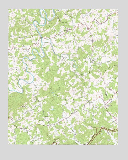
Laurel Springs, NC USGS Topographic Map
Click on map above to begin viewing in our Map Viewer.

This topographic map contains these locations and features:
Feature Name Type Latitude Longitude GNIS ID View Map
Beaver BranchStreamN36.4715°W81.3270°980785View Map
Belview ChurchChurchN36.4512°W81.2804°980975View Map
Church Mill (historical)LocaleN36.4882°W81.3009°1959873View Map
Crab ForkStreamN36.4946°W81.2893°983687View Map
Cranberry CreekStreamN36.4696°W81.3365°983709View Map
Cranberry Primitive Baptist ChurchChurchN36.4487°W81.2748°983706View Map
Ebenezer ChurchChurchN36.3815°W81.3443°984613View Map
Franks KnobSummitN36.4873°W81.3145°1020359View Map
FurchesPopulated PlaceN36.4535°W81.2809°1020384View Map
Huckleberry RidgeRidgeN36.4751°W81.3490°987209View Map
Irwin Mill (historical)LocaleN36.4762°W81.2720°1959890View Map
Irwin Mill (historical)LocaleN36.4904°W81.2915°1959891View Map
Laurel ForkStreamN36.3971°W81.2554°988190View Map
Laurel SpringsSpringN36.4110°W81.2620°1959904View Map
Laurel SpringsPopulated PlaceN36.4115°W81.2629°1021119View Map
Laurel Springs Baptist ChurchChurchN36.4199°W81.2565°988211View Map
Laurel Springs Post OfficePost OfficeN36.4124°W81.2634°2774298View Map
Laurel Springs School (historical)SchoolN36.4171°W81.2581°988212View Map
Laurel Springs Volunteer Fire DepartmentBuildingN36.4126°W81.2630°2638364View Map
Liberty Hill ChurchChurchN36.4560°W81.3668°988436View Map
Little Peak CreekStreamN36.4287°W81.3432°988726View Map
Long BranchStreamN36.4618°W81.3540°988917View Map
Low GapGapN36.4043°W81.3557°989079View Map
Low Gap ChurchChurchN36.4035°W81.3554°989081View Map
Maines Mill (historical)LocaleN36.4857°W81.3015°1959907View Map
Matt Carson CemeteryCemeteryN36.4608°W81.3297°2074417View Map
Meadow ForkStreamN36.3971°W81.2554°989676View Map
Mount Carmel CemeteryCemeteryN36.4876°W81.2943°1959915View Map
Mount Carmel Church of the BrethrenChurchN36.4873°W81.2937°990368View Map
Nathans CreekStreamN36.4590°W81.3470°990872View Map
New HopePopulated PlaceN36.4946°W81.2595°1959922View Map
New Hope Baptist ChurchChurchN36.4946°W81.2590°991034View Map
New Hope CemeteryCemeteryN36.4954°W81.2590°1959923View Map
Ore KnobPopulated PlaceN36.4004°W81.3293°1021752View Map
Peak CreekStreamN36.4329°W81.3470°991984View Map
Peak Creek Church of the BrethrenChurchN36.3779°W81.2956°991985View Map
PedenPopulated PlaceN36.4985°W81.3084°1021852View Map
Perry Mill (historical)LocaleN36.4987°W81.3190°1959927View Map
Piney BranchStreamN36.4432°W81.2962°992320View Map
Piney ForkStreamN36.4115°W81.2648°992327View Map
Pleasant Valley ChurchChurchN36.4546°W81.3120°992575View Map
Prathers CreekStreamN36.4965°W81.3223°992782View Map
Pruitt Mill (historical)LocaleN36.4537°W81.2809°1959939View Map
Pugh Mill (historical)LocaleN36.4996°W81.3048°1959940View Map
Rattlesnake MountainSummitN36.3854°W81.3312°993054View Map
Reeves BranchStreamN36.4210°W81.2523°993219View Map
Roan Creek ChurchChurchN36.3898°W81.3568°993407View Map
ScottvillePopulated PlaceN36.4804°W81.3076°1006366View Map
Silas BranchStreamN36.4351°W81.3618°994792View Map
Skyland AirportAirportN36.4601°W81.3615°998075View Map
The PeakSummitN36.4101°W81.3598°996001View Map
Township of Chestnut HillCivilN36.4890°W81.3544°1026379View Map
Township of Peak CreekCivilN36.4081°W81.3107°1026392View Map
Township of Prathers CreekCivilN36.4932°W81.2521°1026369View Map
TransouPopulated PlaceN36.4040°W81.3004°1022978View Map
Transou ChurchChurchN36.4051°W81.2820°996203View Map
Upper MountainSummitN36.3899°W81.2773°1023051View Map
Weaver Mill (historical)LocaleN36.4993°W81.3143°1959963View Map
Wolf BranchStreamN36.4146°W81.2776°997520View Map

Note: Coordinates in the location and feature list above are referenced to NAD83 datum.


Copyright (C) 2008-2024 Ryan Niemi / Sunset Dynamics ... All Rights Reserved