TopoQuest Logo
Do you find TopoQuest useful?
Help keep TopoQuest running and adding new maps/features by donating!
Bitcoin:  19c7KJd3qBynnjoSw5npx9KScwjBe4ifkT
Litecoin:  LXs6TkuXGGXo1vDsWCkWVdjQX94eUKd6ui
Home View Maps Find Maps Find Places Resources & Links


Trout Dale, Virginia Topographic Map

USGS Map Title: Trout Dale, VA
USGS Map MRC: 36081F4
DRG (GeoTIFF) Download: o36081f4.tif


Neighboring USGS Topographic Map Quads:


  Marion, VA  
36081G5
 

  Atkins, VA  
36081G4
 

  Cedar Springs, VA  
36081G3
 

  Whitetop Mountain, VA  
36081F5
 

  Trout Dale, VA  
36081F4
 

  Middle Fox Creek, VA  
36081F3
 

  Park, NC  
36081E5
 

  Grassy Creek, NC  
36081E4
 

  Mouth of Wilson, VA  
36081E3


Map MRC Location:

N37°
W82°
N37°
W81°
H8 H7 H6 H5 H4 H3 H2 H1
G8 G7 G6 G5 G4 G3 G2 G1
F8 F7 F6 F5 F4 F3 F2 F1
E8 E7 E6 E5 E4 E3 E2 E1
D8 D7 D6 D5 D4 D3 D2 D1
C8 C7 C6 C5 C4 C3 C2 C1
B8 B7 B6 B5 B4 B3 B2 B1
A8 A7 A6 A5 A4 A3 A2 A1
N36°
W82°
N36°
W81°

Trout Dale, VA USGS 1:24K Topographic Map Preview:
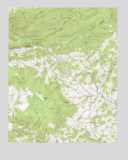
Trout Dale, VA USGS Topographic Map
Click on map above to begin viewing in our Map Viewer.

This topographic map contains these locations and features:
Feature Name Type Latitude Longitude GNIS ID View Map
Adams CemeteryCemeteryN36.6815°W81.3904°1481261View Map
Anderson CemeteryCemeteryN36.6787°W81.4223°1481308View Map
Bearpen RidgeRidgeN36.6451°W81.4601°1481550View Map
Bearpen TrailTrailN36.6585°W81.4607°1488625View Map
Bell HollowValleyN36.7394°W81.4283°1481610View Map
Big Spring RidgeRidgeN36.6307°W81.4846°1481792View Map
Big Wilson CreekStreamN36.6537°W81.4946°1481797View Map
Blevins CemeteryCemeteryN36.6804°W81.4343°1481845View Map
Bobby's TrailTrailN36.7332°W81.4682°1488752View Map
Bobbys RidgeRidgeN36.7346°W81.4501°1481896View Map
Bolt CemeteryCemeteryN36.7109°W81.4509°1481920View Map
Brooks CemeteryCemeteryN36.7104°W81.4932°1482027View Map
Brushy ButtSummitN36.7485°W81.4034°1499173View Map
Campbell CemeteryCemeteryN36.6982°W81.4543°1482284View Map
Comer CemeteryCemeteryN36.6907°W81.4312°1482666View Map
Comers Creek ChurchChurchN36.7101°W81.4812°1482670View Map
Comers Creek TrailTrailN36.7260°W81.4951°1488750View Map
Dainel CemeteryCemeteryN36.6390°W81.3829°1482896View Map
Dickey GapGapN36.7201°W81.4612°1500461View Map
Dickey RidgeRidgeN36.7437°W81.4543°1483006View Map
FairwoodPopulated PlaceN36.6998°W81.4848°1499407View Map
Fairwood CemeteryCemeteryN36.7004°W81.4746°1483337View Map
Fairwood ValleyValleyN36.6957°W81.4693°1488643View Map
First PeakSummitN36.6562°W81.4529°1499414View Map
First Peak TrailTrailN36.6698°W81.4709°1488672View Map
Fox Creek Church (historical)ChurchN36.6890°W81.4215°1501188View Map
Friendship ChurchChurchN36.7012°W81.4098°1483547View Map
GrantPopulated PlaceN36.6623°W81.4040°1499484View Map
Green RidgeRidgeN36.7410°W81.4082°1483809View Map
Grubb CemeteryCemeteryN36.6718°W81.4126°1483856View Map
Hickory RidgeRidgeN36.7229°W81.3976°1484069View Map
Hickory Ridge TrailTrailN36.7240°W81.4621°1488764View Map
High PointSummitN36.7360°W81.4762°1499556View Map
Hightree RockPillarN36.6621°W81.4354°1484102View Map
Hoffman CemeteryCemeteryN36.6673°W81.3834°1484132View Map
Hurricane CampgroundLocaleN36.7226°W81.4909°1488749View Map
Hurricane CreekStreamN36.7221°W81.4873°1484298View Map
Hurricane Creek TrailTrailN36.7190°W81.4943°1488748View Map
Hutton BranchStreamN36.7460°W81.4240°1484303View Map
Jones KnobSummitN36.6737°W81.3779°1484505View Map
Laurel CreekStreamN36.6901°W81.4093°1484696View Map
Laurel Creek DamDamN36.7285°W81.3765°1489915View Map
Laurel Creek School (historical)SchoolN36.7010°W81.4098°1501210View Map
Liberty Hill CemeteryCemeteryN36.6690°W81.4062°1501212View Map
Liberty Hill ChurchChurchN36.6693°W81.4065°1484796View Map
Little Wilson CemeteryCemeteryN36.6315°W81.4065°1485002View Map
Little Wilson ChurchChurchN36.6346°W81.4073°1485003View Map
Little Wilson CreekStreamN36.6254°W81.3882°1485004View Map
Little Wilson CreekStreamN36.6362°W81.4718°1485005View Map
Little Wilson Creek WildernessReserveN36.6603°W81.4619°2035186View Map
Little Wilson School (historical)SchoolN36.6335°W81.4051°1501214View Map
Locust RidgeRidgeN36.7060°W81.4723°1485023View Map
Mill CreekStreamN36.6712°W81.3940°1485407View Map
Mink RidgeRidgeN36.6290°W81.4104°1485494View Map
Mount Rogers National Recreation AreaParkN36.7496°W81.3754°1488642View Map
Muddy BranchStreamN36.7448°W81.4934°1485734View Map
Mullins Branch TrailTrailN36.7429°W81.4582°1488673View Map
Opossum CreekStreamN36.7010°W81.4843°1485982View Map
Pugh CemeteryCemeteryN36.6265°W81.3857°1486442View Map
Pugh CemeteryCemeteryN36.6443°W81.4198°1486443View Map
Quebec BranchStreamN36.6487°W81.4934°1486466View Map
Raccoon BranchStreamN36.7465°W81.4251°1486474View Map
Raccoon Branch CampgroundLocaleN36.7471°W81.4251°1488766View Map
Raccoon Branch ShelterLocaleN36.7315°W81.4721°1488765View Map
Raccoon Branch WildernessReserveN36.7392°W81.4594°2767378View Map
Razor Ridge ChurchChurchN36.6901°W81.3884°1486526View Map
Razor Ridge School (historical)SchoolN36.6912°W81.3887°1501244View Map
Reedy CemeteryCemeteryN36.6476°W81.3751°1486564View Map
Ripshin CreekStreamN36.6962°W81.4082°1486624View Map
Rocky HollowValleyN36.6835°W81.4434°1486740View Map
Ross CemeteryCemeteryN36.6818°W81.3937°1486778View Map
Scales TrailTrailN36.6607°W81.4887°1488627View Map
Scott BranchStreamN36.7323°W81.4382°1486970View Map
Second PeakSummitN36.6657°W81.4596°1486992View Map
Sells KnobSummitN36.7035°W81.3868°1500051View Map
Shanty BranchStreamN36.7298°W81.4948°1488751View Map
Snake Den RidgeRidgeN36.7271°W81.4543°1500548View Map
Solomon BranchStreamN36.6998°W81.4587°1487381View Map
Stone MountainSummitN36.6712°W81.4757°1500164View Map
Straight MountainSummitN36.7343°W81.3968°1500175View Map
Sugar BranchStreamN36.6751°W81.3971°1487686View Map
Sullivan CemeteryCemeteryN36.7082°W81.4059°1487711View Map
Switchback TrailTrailN36.6932°W81.4798°1488759View Map
Third PeakSummitN36.6707°W81.4659°1500218View Map
Third Peak TrailTrailN36.6765°W81.4718°1488626View Map
Town of TroutdaleCivilN36.7022°W81.4413°2391451View Map
Trout DalePopulated PlaceN36.7021°W81.4404°1502812View Map
Trout Dale CemeteryCemeteryN36.7023°W81.4332°1487997View Map
Troutdale Community Volunteer Fire DepartmentBuildingN36.7030°W81.4358°2086257View Map
Troutdale Post OfficePost OfficeN36.7026°W81.4391°2780822View Map
Upper Sharp KnobSummitN36.7062°W81.3757°1501266View Map
VolneyPopulated PlaceN36.6251°W81.3882°1500264View Map
Wallen CreekStreamN36.6329°W81.4020°1488168View Map
Watson CemeteryCemeteryN36.7090°W81.4868°1488208View Map
Weiss BranchStreamN36.6465°W81.4054°1488222View Map
Wilburn BranchStreamN36.6373°W81.4757°1488360View Map
Wilburn RidgeRidgeN36.6421°W81.4959°1488363View Map
Wilson Creek DistrictCivilN36.6448°W81.4076°1927573View Map
Woods CemeteryCemeteryN36.6893°W81.3959°1488478View Map
Young CemeteryCemeteryN36.6332°W81.4129°1487125View Map
Young CemeteryCemeteryN36.6973°W81.4101°1487126View Map

Note: Coordinates in the location and feature list above are referenced to NAD83 datum.


Copyright (C) 2008-2024 Ryan Niemi / Sunset Dynamics ... All Rights Reserved