TopoQuest Logo
Do you find TopoQuest useful?
Help keep TopoQuest running and adding new maps/features by donating!
Bitcoin:  19c7KJd3qBynnjoSw5npx9KScwjBe4ifkT
Litecoin:  LXs6TkuXGGXo1vDsWCkWVdjQX94eUKd6ui
Home View Maps Find Maps Find Places Resources & Links


Belfair, Washington Topographic Map

USGS Map Title: Belfair, WA
USGS Map MRC: 47122D7
DRG (GeoTIFF) Download: o47122d7.tif


Neighboring USGS Topographic Map Quads:


  Holly, WA  
47122E8
 

  Wildcat Lake, WA  
47122E7
 

  Bremerton West, WA  
47122E6
 

  Lake Wooten, WA  
47122D8
 

  Belfair, WA  
47122D7
 

  Burley, WA  
47122D6
 

  Mason Lake, WA  
47122C8
 

  Vaughn, WA  
47122C7
 

  Fox Island, WA  
47122C6


Map MRC Location:

N48°
W123°
N48°
W122°
H8 H7 H6 H5 H4 H3 H2 H1
G8 G7 G6 G5 G4 G3 G2 G1
F8 F7 F6 F5 F4 F3 F2 F1
E8 E7 E6 E5 E4 E3 E2 E1
D8 D7 D6 D5 D4 D3 D2 D1
C8 C7 C6 C5 C4 C3 C2 C1
B8 B7 B6 B5 B4 B3 B2 B1
A8 A7 A6 A5 A4 A3 A2 A1
N47°
W123°
N47°
W122°

Belfair, WA USGS 1:24K Topographic Map Preview:
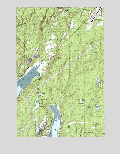
Belfair, WA USGS Topographic Map
Click on map above to begin viewing in our Map Viewer.

This topographic map contains these locations and features:
Feature Name Type Latitude Longitude GNIS ID View Map
AllynPopulated PlaceN47.3857°W122.8276°1515819View Map
Allyn Baptist ChurchChurchN47.3825°W122.8343°2609218View Map
Allyn Census Designated PlaceCensusN47.3864°W122.8385°2586727View Map
Allyn Post OfficePost OfficeN47.3811°W122.8314°2606907View Map
Allynview Mobile ParkPopulated PlaceN47.3801°W122.8330°2607051View Map
Allynview Recreational Vehicle ParkLocaleN47.3806°W122.8321°2608239View Map
Bear CreekStreamN47.4926°W122.8051°1516250View Map
Bear Creek QuarryMineN47.4974°W122.8158°2605604View Map
Bear Creek StationLocaleN47.4954°W122.8057°1516261View Map
BelfairPopulated PlaceN47.4506°W122.8274°1516383View Map
Belfair Assembly of God ChurchChurchN47.4410°W122.8347°2609242View Map
Belfair Census Designated PlaceCensusN47.4512°W122.8473°2586728View Map
Belfair Christian SchoolSchoolN47.4404°W122.8349°1530673View Map
Belfair Community Baptist ChurchChurchN47.4447°W122.8310°2609243View Map
Belfair Division (historical)CensusN47.3968°W122.8499°1939448View Map
Belfair Elementary SchoolSchoolN47.4389°W122.8341°1530803View Map
Belfair Post OfficePost OfficeN47.4548°W122.8180°2769241View Map
Bremerton National AirportAirportN47.4928°W122.7624°1533692View Map
Carney LakeLakeN47.4033°W122.7610°1517410View Map
Coon LakeLakeN47.3842°W122.8668°1518049View Map
Coulter CreekStreamN47.4062°W122.8193°1518197View Map
Devereaux LakeLakeN47.4059°W122.8481°1518688View Map
Golden Bell Mobile Home ParkPopulated PlaceN47.4402°W122.8372°2607084View Map
Haven in Allyn Assisted Living CenterBuildingN47.3810°W122.8364°2607801View Map
Hawkins Middle SchoolSchoolN47.4158°W122.8412°1530738View Map
Huson QuarryMineN47.4668°W122.8362°2605605View Map
Irene CreekStreamN47.4542°W122.8331°2440032View Map
Kellums Lake IsthmusIsthmusN47.4179°W122.8338°1530543View Map
Kingdom Hall of Jehovahs WitnessesChurchN47.4184°W122.8408°2609244View Map
Kitsap County Fire District 7 South Kitsap Fire and Rescue Station 18 Bremerton AirportBuildingN47.4920°W122.7673°2643959View Map
Kitsap County Fire District 7 South Kitsap Fire and Rescue Station 7 Wye LakeBuildingN47.4284°W122.7549°2643955View Map
Kriegler LakeLakeN47.4562°W122.7659°1521774View Map
Lake AndersonReservoirN47.3816°W122.8464°1532084View Map
Lake Anderson DamDamN47.3798°W122.8479°1532083View Map
Lake KoenemanLakeN47.4096°W122.7844°1519497View Map
Lakeland Village Golf CourseLocaleN47.3913°W122.8377°2608411View Map
Larson LakeSwampN47.4574°W122.8540°1521913View Map
Lider LakeSwampN47.4816°W122.7926°1522065View Map
Lynch CoveBayN47.4362°W122.8521°1522603View Map
Mason County Fire District 5 Station 1 AllynBuildingN47.3828°W122.8297°2643462View Map
Mason County Fire District 5 Station 2 VictorBuildingN47.3783°W122.8159°2643839View Map
Miggie CreekStreamN47.4631°W122.8197°2516391View Map
Mission CreekStreamN47.4306°W122.8726°1523270View Map
Mission Creek Youth CampSchoolN47.4848°W122.8629°1530740View Map
North BayBayN47.3785°W122.8198°1523722View Map
North East Fork Union RiverStreamN47.4954°W122.8026°1530195View Map
North Mason Bible ChurchChurchN47.4127°W122.8437°2608612View Map
North Mason High SchoolSchoolN47.4134°W122.8413°1530739View Map
North Mason Regional Fire Authority Station 21BuildingN47.4603°W122.8268°2606018View Map
North Mason Timberland Library BelfairBuildingN47.4417°W122.8341°2610202View Map
North Mason United Methodist ChurchChurchN47.4647°W122.8083°2609245View Map
Old Belfair QuarryMineN47.4898°W122.8241°2605606View Map
Plum PointCapeN47.4281°W122.8746°1524516View Map
Point VictorCapeN47.4029°W122.8185°1534457View Map
Port of Allyn Public DockLocaleN47.3836°W122.8260°2607962View Map
Prince of Peace Catholic ChurchChurchN47.4623°W122.8486°2609246View Map
Rose PointPopulated PlaceN47.4184°W122.8685°1530235View Map
Saint Albans-Tacoma Girl Scout CampLocaleN47.4040°W122.8440°1525347View Map
Saint Hugh Episcopal ChurchChurchN47.3778°W122.8343°2609219View Map
Sand Hill Elementary SchoolSchoolN47.4586°W122.8464°1530741View Map
Sherwood CreekStreamN47.3765°W122.8315°1525681View Map
Shillinger QuarryMineN47.4869°W122.7965°2605607View Map
Sweetwater CreekStreamN47.4384°W122.8412°2089297View Map
The Church of Jesus Christ of Latter Day SaintsChurchN47.4100°W122.8390°2609220View Map
Union RiverStreamN47.4423°W122.8446°1527614View Map
VictorPopulated PlaceN47.3776°W122.8160°1527707View Map
Viola CreekStreamN47.4644°W122.8286°2516393View Map
Wye LakeLakeN47.4265°W122.7586°1528329View Map

Note: Coordinates in the location and feature list above are referenced to NAD83 datum.


Copyright (C) 2008-2024 Ryan Niemi / Sunset Dynamics ... All Rights Reserved