TopoQuest Logo
Do you find TopoQuest useful?
Help keep TopoQuest running and adding new maps/features by donating!
Bitcoin:  19c7KJd3qBynnjoSw5npx9KScwjBe4ifkT
Litecoin:  LXs6TkuXGGXo1vDsWCkWVdjQX94eUKd6ui
Home View Maps Find Maps Find Places Resources & Links


Muldrow, Oklahoma Topographic Map

USGS Map Title: Muldrow, OK
USGS Map MRC: 35094D5
DRG (GeoTIFF) Download: o35094d5.tif


Neighboring USGS Topographic Map Quads:


  Brushy, OK  
35094E6
 

  Nicut, OK  
35094E5
 

  Uniontown, AR  
35094E4
 

  Gans, OK  
35094D6
 

  Muldrow, OK  
35094D5
 

  Fort Smith, AR  
35094D4
 

  Muldrow SW, OK  
35094C6
 

  Fort Coffee, OK  
35094C5
 

  South Fort Smith, AR  
35094C4


Map MRC Location:

N36°
W95°
N36°
W94°
H8 H7 H6 H5 H4 H3 H2 H1
G8 G7 G6 G5 G4 G3 G2 G1
F8 F7 F6 F5 F4 F3 F2 F1
E8 E7 E6 E5 E4 E3 E2 E1
D8 D7 D6 D5 D4 D3 D2 D1
C8 C7 C6 C5 C4 C3 C2 C1
B8 B7 B6 B5 B4 B3 B2 B1
A8 A7 A6 A5 A4 A3 A2 A1
N35°
W95°
N35°
W94°

Muldrow, OK USGS 1:24K Topographic Map Preview:
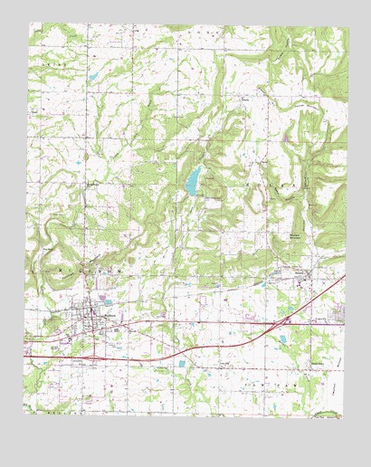
Muldrow, OK USGS Topographic Map
Click on map above to begin viewing in our Map Viewer.

This topographic map contains these locations and features:
Feature Name Type Latitude Longitude GNIS ID View Map
Faulkner CemeteryCemeteryN35.3979°W94.5897°1092772View Map
Flat RockSummitN35.4273°W94.6183°1092879View Map
Holiness ChurchChurchN35.4023°W94.5838°1093843View Map
LibertyPopulated PlaceN35.4776°W94.5424°1094600View Map
Liberty Area Volunteer Fire AssociationBuildingN35.4781°W94.5440°2657221View Map
Liberty CemeteryCemeteryN35.4747°W94.5428°2710976View Map
Liberty Census Designated PlaceCensusN35.4656°W94.5442°2584384View Map
Liberty CommunityCivilN35.4575°W94.5647°2631122View Map
Liberty Elementary SchoolSchoolN35.4769°W94.5408°2712971View Map
Lone OakPopulated PlaceN35.3906°W94.5488°1100590View Map
LongCivilN35.4402°W94.5464°2631124View Map
LongPopulated PlaceN35.4976°W94.5847°1100592View Map
Long CemeteryCemeteryN35.4972°W94.5894°2710977View Map
Long Census Designated PlaceCensusN35.4992°W94.5470°2408126View Map
Mayfield MountainSummitN35.4329°W94.5230°1095192View Map
Mineral Springs ChurchChurchN35.4487°W94.6019°1095432View Map
Moffett BottomFlatN35.3881°W94.5027°1095466View Map
MuldrowPopulated PlaceN35.4062°W94.5988°1095696View Map
Muldrow CemeteryCemeteryN35.3906°W94.5677°1095697View Map
Muldrow DamDamN35.4451°W94.5552°1751006View Map
Muldrow Elementary SchoolSchoolN35.4076°W94.5980°1794237View Map
Muldrow Fire Department Station 1BuildingN35.4092°W94.5989°2656828View Map
Muldrow Fire Department Station 2BuildingN35.3912°W94.5875°2657374View Map
Muldrow High SchoolSchoolN35.3994°W94.6127°1794235View Map
Muldrow LakeReservoirN35.4451°W94.5552°1751007View Map
Muldrow Middle SchoolSchoolN35.3995°W94.6070°1794236View Map
Muldrow Police DepartmentBuildingN35.4091°W94.5995°2757674View Map
O'Neal HillSummitN35.4776°W94.5316°1096080View Map
Oknoname 135003 DamDamN35.4818°W94.5986°1755775View Map
Oknoname 135003 ReservoirReservoirN35.4818°W94.5986°1755776View Map
Pafford Emergency Medical Services Muldrow SubstationBuildingN35.4067°W94.5494°2695920View Map
Petree MountainSummitN35.4748°W94.5124°1096580View Map
RemyPopulated PlaceN35.4565°W94.5341°1100785View Map
Remy HollowValleyN35.4454°W94.5174°1097161View Map
RolandPopulated PlaceN35.4212°W94.5147°1097399View Map
Roland CemeteryCemeteryN35.4187°W94.5269°1097400View Map
Roland Elementary SchoolSchoolN35.4191°W94.5170°1790763View Map
Roland Fire DepartmentBuildingN35.4078°W94.5137°2656848View Map
Roland High SchoolSchoolN35.4172°W94.5168°1790453View Map
Roland Junior High SchoolSchoolN35.4173°W94.5188°1790454View Map
Roland Police DepartmentBuildingN35.4149°W94.5139°2757543View Map
Shady GrovePopulated PlaceN35.3906°W94.5133°1097933View Map
Shady Grove CemeteryCemeteryN35.3947°W94.5139°2710982View Map
Town of MuldrowCivilN35.4040°W94.5969°2413026View Map
Town of RolandCivilN35.4150°W94.5131°2412571View Map
Township of MuldrowCivilN35.4195°W94.6002°1824614View Map
Township of RolandCivilN35.4334°W94.5086°1824615View Map
Turnham MountainSummitN35.4276°W94.5927°1099075View Map
Upper Camp Creek CemeteryCemeteryN35.4445°W94.5560°1099190View Map
Woodland Hills ChurchChurchN35.4059°W94.5074°1099986View Map

Note: Coordinates in the location and feature list above are referenced to NAD83 datum.


Copyright (C) 2008-2025 Ryan Niemi / Sunset Dynamics ... All Rights Reserved