TopoQuest Logo
Do you find TopoQuest useful?
Help keep TopoQuest running and adding new maps/features by donating!
Bitcoin:  19c7KJd3qBynnjoSw5npx9KScwjBe4ifkT
Litecoin:  LXs6TkuXGGXo1vDsWCkWVdjQX94eUKd6ui
Home View Maps Find Maps Find Places Resources & Links


Nicut, Oklahoma Topographic Map

USGS Map Title: Nicut, OK
USGS Map MRC: 35094E5
DRG (GeoTIFF) Download: o35094e5.tif


Neighboring USGS Topographic Map Quads:


  Greasy, OK  
35094F6
 

  Big Round Mountain, OK  
35094F5
 

  Natural Dam, AR  
35094F4
 

  Brushy, OK  
35094E6
 

  Nicut, OK  
35094E5
 

  Uniontown, AR  
35094E4
 

  Gans, OK  
35094D6
 

  Muldrow, OK  
35094D5
 

  Fort Smith, AR  
35094D4


Map MRC Location:

N36°
W95°
N36°
W94°
H8 H7 H6 H5 H4 H3 H2 H1
G8 G7 G6 G5 G4 G3 G2 G1
F8 F7 F6 F5 F4 F3 F2 F1
E8 E7 E6 E5 E4 E3 E2 E1
D8 D7 D6 D5 D4 D3 D2 D1
C8 C7 C6 C5 C4 C3 C2 C1
B8 B7 B6 B5 B4 B3 B2 B1
A8 A7 A6 A5 A4 A3 A2 A1
N35°
W95°
N35°
W94°

Nicut, OK USGS 1:24K Topographic Map Preview:
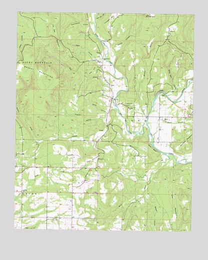
Nicut, OK USGS Topographic Map
Click on map above to begin viewing in our Map Viewer.

This topographic map contains these locations and features:
Feature Name Type Latitude Longitude GNIS ID View Map
BelfonteCivilN35.5368°W94.5507°2631071View Map
BelfontePopulated PlaceN35.5443°W94.5549°1853456View Map
Belfonte Census Designated PlaceCensusN35.5368°W94.5507°2407823View Map
Belfonte Elementary SchoolSchoolN35.5704°W94.5451°1089977View Map
Blackbird MountainSummitN35.5520°W94.5041°1090218View Map
Board HollowValleyN35.5204°W94.5333°1090315View Map
Briar CreekStreamN35.5440°W94.5188°1090480View Map
Copic ChurchChurchN35.6018°W94.5663°1091681View Map
Copic SlabPopulated PlaceN35.6098°W94.5591°1100320View Map
Curts RanchLocaleN35.6151°W94.5177°1091896View Map
Dead Man HollowValleyN35.5784°W94.5113°1091967View Map
Eagle HollowValleyN35.5981°W94.5691°1092331View Map
Eagle MountainSummitN35.5415°W94.5699°1092333View Map
Flanagan MountainSummitN35.6226°W94.5572°1092874View Map
Fork Handle HollowValleyN35.6190°W94.5730°1092946View Map
Hunt Mill HollowValleyN35.6212°W94.5700°1094021View Map
John Seabolt CemeteryCemeteryN35.5987°W94.5641°1094237View Map
Judy HillSummitN35.5937°W94.5702°1094269View Map
Lee ChurchChurchN35.5720°W94.5477°1094555View Map
Little Lee CreekStreamN35.5637°W94.5327°1094788View Map
Low Gap MountainSummitN35.6159°W94.5991°1095028View Map
Mission BranchStreamN35.5631°W94.5338°1095443View Map
New Hope ChurchChurchN35.5223°W94.6197°1095818View Map
NicutPopulated PlaceN35.5840°W94.5594°1100673View Map
NicutCivilN35.5910°W94.5817°2631141View Map
Nicut Census Designated PlaceCensusN35.5986°W94.5626°2584386View Map
Nicut Volunteer Fire Department Station 1BuildingN35.5517°W94.5711°2657330View Map
Nicut Volunteer Fire Department Station 2BuildingN35.5840°W94.5594°2657421View Map
Nicut Volunteer Fire Department Station 3BuildingN35.5354°W94.5739°2657328View Map
Pine MountainSummitN35.5173°W94.5116°1096666View Map
Polecat CreekStreamN35.5676°W94.5527°1096800View Map
Procter HollowValleyN35.5645°W94.5624°1096935View Map
Rabbit HollowValleyN35.6045°W94.5585°1097011View Map
Reeder FordPopulated PlaceN35.5790°W94.5197°1100781View Map
Roland DivisionCivilN35.5111°W94.5319°1937836View Map
Salt CreekStreamN35.5748°W94.5563°1097675View Map
Seabolt CemeteryCemeteryN35.5731°W94.5472°1097892View Map
ShortCivilN35.5957°W94.5043°2631173View Map
ShortLocaleN35.5640°W94.5219°1098015View Map
Short BranchStreamN35.5545°W94.5291°1101658View Map
Short ChurchChurchN35.5670°W94.5008°1098017View Map
Smith HollowValleyN35.5681°W94.5607°1098135View Map
Star BluffCliffN35.5476°W94.5280°1098491View Map
Township of LongCivilN35.5640°W94.5419°1824606View Map

Note: Coordinates in the location and feature list above are referenced to NAD83 datum.


Copyright (C) 2008-2025 Ryan Niemi / Sunset Dynamics ... All Rights Reserved