TopoQuest Logo
Do you find TopoQuest useful?
Help keep TopoQuest running and adding new maps/features by donating!
Bitcoin:  19c7KJd3qBynnjoSw5npx9KScwjBe4ifkT
Litecoin:  LXs6TkuXGGXo1vDsWCkWVdjQX94eUKd6ui
Home View Maps Find Maps Find Places Resources & Links


Fort Coffee, Oklahoma Topographic Map

USGS Map Title: Fort Coffee, OK
USGS Map MRC: 35094C5
DRG (GeoTIFF) Download: o35094c5.tif


Neighboring USGS Topographic Map Quads:


  Gans, OK  
35094D6
 

  Muldrow, OK  
35094D5
 

  Fort Smith, AR  
35094D4
 

  Muldrow SW, OK  
35094C6
 

  Fort Coffee, OK  
35094C5
 

  South Fort Smith, AR  
35094C4
 

  Panama, OK  
35094B6
 

  Spiro, OK  
35094B5
 

  Hackett, AR  
35094B4


Map MRC Location:

N36°
W95°
N36°
W94°
H8 H7 H6 H5 H4 H3 H2 H1
G8 G7 G6 G5 G4 G3 G2 G1
F8 F7 F6 F5 F4 F3 F2 F1
E8 E7 E6 E5 E4 E3 E2 E1
D8 D7 D6 D5 D4 D3 D2 D1
C8 C7 C6 C5 C4 C3 C2 C1
B8 B7 B6 B5 B4 B3 B2 B1
A8 A7 A6 A5 A4 A3 A2 A1
N35°
W95°
N35°
W94°

Fort Coffee, OK USGS 1:24K Topographic Map Preview:
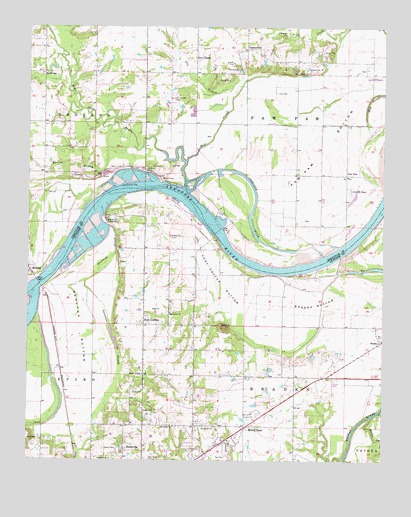
Fort Coffee, OK USGS Topographic Map
Click on map above to begin viewing in our Map Viewer.

This topographic map contains these locations and features:
Feature Name Type Latitude Longitude GNIS ID View Map
BaldridgePopulated PlaceN35.3620°W94.6199°1100190View Map
Barrow BranchStreamN35.3398°W94.5877°1089873View Map
Big Skin BayouStreamN35.3287°W94.5705°1090129View Map
BradenPopulated PlaceN35.2843°W94.5013°1100231View Map
Braden BottomBendN35.2956°W94.5244°1090444View Map
Cherokee ChuteChannelN35.3234°W94.5463°1091237View Map
CottonwoodPopulated PlaceN35.3684°W94.5491°1100327View Map
Cottonwood CemeteryCemeteryN35.3631°W94.5505°1091709View Map
Deadman SloughStreamN35.3176°W94.5969°1091977View Map
Fort CoffeePopulated PlaceN35.2893°W94.5844°1092956View Map
Fort Coffee BottomBendN35.3006°W94.5572°1092957View Map
Fort Coffee CemeteryCemeteryN35.2917°W94.5828°2747467View Map
Fort Coffee Volunteer Fire DepartmentBuildingN35.2877°W94.5795°2656876View Map
Fox BranchStreamN35.3720°W94.5163°1093005View Map
Lees ChapelLocaleN35.3662°W94.5672°1094566View Map
Lees Chapel CemeteryCemeteryN35.3534°W94.5741°1094567View Map
Macedonia ChurchChurchN35.2926°W94.5752°1095075View Map
Mud SloughGutN35.3451°W94.5594°1095683View Map
Murry SpurPopulated PlaceN35.2598°W94.5486°1095713View Map
Murry Spur Volunteer Fire DepartmentBuildingN35.2637°W94.5396°2657352View Map
Oak Lodge ChurchChurchN35.2598°W94.5738°1096117View Map
Paw PawPopulated PlaceN35.3323°W94.5136°1100724View Map
Paw Paw BottomBendN35.3395°W94.5216°1096474View Map
Paw Paw CemeteryCemeteryN35.3275°W94.5119°2710979View Map
Paw Paw ChapelChurchN35.3281°W94.5119°1096475View Map
Rabbit BranchStreamN35.3718°W94.5166°1097001View Map
RedlandPopulated PlaceN35.3048°W94.6244°1100780View Map
Redland BottomBendN35.2884°W94.6080°1097140View Map
Site of Old Fort CoffeeLocaleN35.3184°W94.5977°1098069View Map
Skullyville CemeteryCemeteryN35.2511°W94.5942°2711802View Map
Sweetbriar AirportAirportN35.2563°W94.5790°2676454View Map
Town of Fort CoffeeCivilN35.2942°W94.5726°2412639View Map
Township of BradenCivilN35.2876°W94.5030°1824668View Map
Township of Paw PawCivilN35.3529°W94.5363°1824619View Map
W.D. Mayo Lock and DamDamN35.3151°W94.5586°1751394View Map
Wells CreekStreamN35.2626°W94.5044°1099480View Map
Wilson RockSummitN35.3318°W94.5772°1099897View Map
Wilson Rock CemeteryCemeteryN35.3319°W94.5800°2710984View Map

Note: Coordinates in the location and feature list above are referenced to NAD83 datum.


Copyright (C) 2008-2024 Ryan Niemi / Sunset Dynamics ... All Rights Reserved