TopoQuest Logo
Do you find TopoQuest useful?
Help keep TopoQuest running and adding new maps/features by donating!
Bitcoin:  19c7KJd3qBynnjoSw5npx9KScwjBe4ifkT
Litecoin:  LXs6TkuXGGXo1vDsWCkWVdjQX94eUKd6ui
Home View Maps Find Maps Find Places Resources & Links


Mule Creek, New Mexico Topographic Map

USGS Map Title: Mule Creek, NM
USGS Map MRC: 33108A8
DRG (GeoTIFF) Download: o33108a8.tif


Neighboring USGS Topographic Map Quads:


  Harden Cienega, NM  
33109B1
 

  Wilson Mountain, NM  
33108B8
 

  Moon Ranch, NM  
33108B7
 

  Big Lue Mountains, AZ  
33109A1
 

  Mule Creek, NM  
33108A8
 

  Bear Mountain, NM  
33108A7
 

  Tillie Hall Peak, NM  
32109H1
 

  Crookson Peak, NM  
32108H8
 

  Applegate Mountain, NM  
32108H7


Map MRC Location:

N34°
W109°
N34°
W108°
H8 H7 H6 H5 H4 H3 H2 H1
G8 G7 G6 G5 G4 G3 G2 G1
F8 F7 F6 F5 F4 F3 F2 F1
E8 E7 E6 E5 E4 E3 E2 E1
D8 D7 D6 D5 D4 D3 D2 D1
C8 C7 C6 C5 C4 C3 C2 C1
B8 B7 B6 B5 B4 B3 B2 B1
A8 A7 A6 A5 A4 A3 A2 A1
N33°
W109°
N33°
W108°

Mule Creek, NM USGS 1:24K Topographic Map Preview:
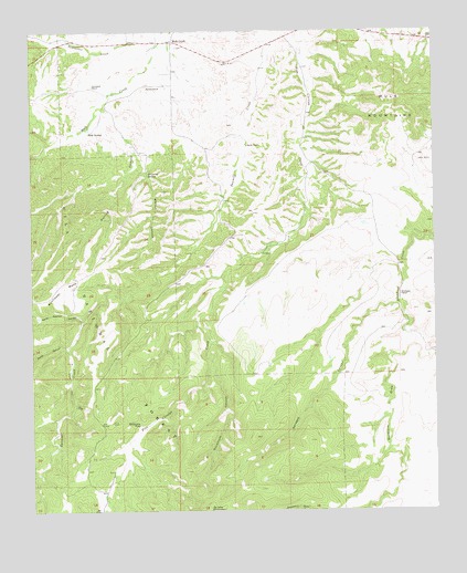
Mule Creek, NM USGS Topographic Map
Click on map above to begin viewing in our Map Viewer.

This topographic map contains these locations and features:
Feature Name Type Latitude Longitude GNIS ID View Map
Ball Park TankReservoirN33.0308°W108.9593°899048View Map
Bastard Basin TankReservoirN33.0081°W108.9298°2038359View Map
Bathtub CanyonValleyN33.0840°W108.9859°899295View Map
Boiling CanyonValleyN33.1037°W108.9745°903990View Map
Boiling TankReservoirN33.0658°W108.9881°898986View Map
Bradberry TankReservoirN33.0280°W108.9947°898981View Map
Buckhorn DrawValleyN33.0456°W108.8837°904150View Map
Cattle Guard TankReservoirN33.0265°W108.9809°898982View Map
Corner TankReservoirN33.0206°W108.9095°2038416View Map
Dripping SpringSpringN33.0880°W108.9643°905859View Map
East Walnut TankReservoirN33.0689°W108.9947°898985View Map
East Wilkinson TankReservoirN33.0220°W108.9490°2038453View Map
Hardluck TankReservoirN33.0508°W108.9987°898987View Map
Harkey RanchLocaleN33.1103°W108.9642°906846View Map
Hell Hole Wilderness Study AreaParkN33.0351°W108.9590°935858View Map
Johnson TankReservoirN33.0151°W108.9495°2038521View Map
Juniper TankReservoirN33.0300°W108.9361°899049View Map
Larremore RanchLocaleN33.1112°W108.9812°907857View Map
McDonald TankReservoirN33.0405°W108.9836°898988View Map
Mount Owens TankReservoirN33.0149°W108.9569°929099View Map
Mule CreekPopulated PlaceN33.1220°W108.9562°908973View Map
Mule Creek Post OfficePost OfficeN33.1218°W108.9563°2781536View Map
Mule Creek WellWellN33.1203°W108.9878°898984View Map
Mule MountainsRangeN33.1053°W108.8837°920652View Map
Mule SpringSpringN33.0992°W108.9825°908976View Map
North Sawmill CanyonValleyN33.0495°W108.9840°909185View Map
Pasture TankReservoirN33.0161°W108.9889°898983View Map
Racetrack CanyonValleyN33.0373°W108.9437°909952View Map
Racetrack TankReservoirN33.0095°W108.9479°898991View Map
Roadside TankReservoirN33.0550°W108.9622°914229View Map
Round Mountain TankReservoirN33.0281°W108.9306°899050View Map
Sawmill WellWellN33.0492°W108.9845°898990View Map
Smith CanyonValleyN33.0431°W108.9887°911149View Map
Smith Mountain TankReservoirN33.0364°W108.9797°898979View Map
South Fork TankReservoirN33.0725°W108.9705°898989View Map
Sparaque TankReservoirN33.0090°W108.9400°898992View Map
Sprague CanyonValleyN33.0537°W108.8876°911306View Map
Steer Pasture TankReservoirN33.0343°W108.9738°898980View Map
Sunflower MesaSummitN33.0562°W108.9945°911492View Map
Taylor RanchLocaleN33.1103°W108.9642°911562View Map
Tennessee SpringSpringN33.1215°W108.9959°2038712View Map
Trail TankReservoirN33.0242°W108.9397°899051View Map
Walnut CanyonValleyN33.0926°W108.9659°912149View Map
Walnut SpringSpringN33.0784°W108.9623°898993View Map
Wilkinson RanchLocaleN33.0562°W108.8859°912388View Map
Wilkinson TankReservoirN33.0226°W108.9670°912389View Map
Y Six RanchLocaleN33.0670°W108.9290°912512View Map

Note: Coordinates in the location and feature list above are referenced to NAD83 datum.


Copyright (C) 2008-2024 Ryan Niemi / Sunset Dynamics ... All Rights Reserved