TopoQuest Logo
Do you find TopoQuest useful?
Help keep TopoQuest running and adding new maps/features by donating!
Bitcoin:  19c7KJd3qBynnjoSw5npx9KScwjBe4ifkT
Litecoin:  LXs6TkuXGGXo1vDsWCkWVdjQX94eUKd6ui
Home View Maps Find Maps Find Places Resources & Links


Munds Draw, Arizona Topographic Map

USGS Map Title: Munds Draw, AZ
USGS Map MRC: 34112G2
DRG (GeoTIFF) Download: o34112g2.tif


Neighboring USGS Topographic Map Quads:


  Hell Point, AZ  
34112H3
 

  Perkinsville, AZ  
34112H2
 

  Sycamore Basin, AZ  
34112H1
 

  King Canyon, AZ  
34112G3
 

  Munds Draw, AZ  
34112G2
 

  Clarkdale, AZ  
34112G1
 

  Prescott Valley North, AZ  
34112F3
 

  Hickey Mountain, AZ  
34112F2
 

  Cottonwood, AZ  
34112F1


Map MRC Location:

N35°
W113°
N35°
W112°
H8 H7 H6 H5 H4 H3 H2 H1
G8 G7 G6 G5 G4 G3 G2 G1
F8 F7 F6 F5 F4 F3 F2 F1
E8 E7 E6 E5 E4 E3 E2 E1
D8 D7 D6 D5 D4 D3 D2 D1
C8 C7 C6 C5 C4 C3 C2 C1
B8 B7 B6 B5 B4 B3 B2 B1
A8 A7 A6 A5 A4 A3 A2 A1
N34°
W113°
N34°
W112°

Munds Draw, AZ USGS 1:24K Topographic Map Preview:
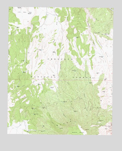
Munds Draw, AZ USGS Topographic Map
Click on map above to begin viewing in our Map Viewer.

This topographic map contains these locations and features:
Feature Name Type Latitude Longitude GNIS ID View Map
Antelope TankReservoirN34.8330°W112.2109°25687View Map
Bakers PassGapN34.8045°W112.1357°25901View Map
Bakers Pass TankReservoirN34.8273°W112.1373°25902View Map
Black Mesa Tank Number OneReservoirN34.8685°W112.2278°26412View Map
Black Mesa Tank Number TwoReservoirN34.8745°W112.2400°26413View Map
Bodkin TankReservoirN34.7761°W112.2091°26571View Map
CCC CanyonValleyN34.7553°W112.2329°27139View Map
CCC TankReservoirN34.7536°W112.2255°27141View Map
China Dam TankReservoirN34.8222°W112.2310°38332View Map
Collins TankReservoirN34.8082°W112.1946°27820View Map
Contrary TankReservoirN34.8109°W112.1453°27866View Map
Dam TankReservoirN34.8225°W112.2310°28254View Map
Elderberry SpringSpringN34.7595°W112.1521°38437View Map
First ViewSummitN34.7775°W112.1418°29014View Map
Halfway TankReservoirN34.7968°W112.2398°29690View Map
Harolds TankReservoirN34.7755°W112.2195°29758View Map
Haynes ShaftMineN34.7561°W112.1316°29809View Map
Henry TankReservoirN34.8175°W112.1347°38501View Map
Honey Bee TankReservoirN34.8109°W112.2332°30088View Map
Horse Camp TanksReservoirN34.7959°W112.1993°30130View Map
Horseshoe CanyonValleyN34.8747°W112.1604°30188View Map
Horseshoe TankReservoirN34.8011°W112.1537°30201View Map
Howards TankReservoirN34.7926°W112.1345°30258View Map
Little Black MesaSummitN34.8689°W112.2327°31033View Map
Mormon Pocket TankReservoirN34.8490°W112.1361°32052View Map
Munds Tank Number OneReservoirN34.8308°W112.1976°32197View Map
Munds Tank Number TwoReservoirN34.7993°W112.2152°32198View Map
Narrow Gauge TankReservoirN34.7699°W112.2195°32243View Map
Pocket TankReservoirN34.8745°W112.1366°38705View Map
Red FlatFlatN34.8489°W112.1627°33439View Map
Red Flat TankReservoirN34.8457°W112.1700°33441View Map
Red Point TankReservoirN34.8547°W112.2413°33492View Map
Red Point Tank DamDamN34.8547°W112.2413°38742View Map
Red Point WellWellN34.8495°W112.2485°42685View Map
Road Canyon TankReservoirN34.8131°W112.1694°33648View Map
Road TankReservoirN34.7554°W112.1532°33659View Map
Section House SpringSpringN34.7642°W112.1413°34236View Map
Shed TankReservoirN34.7563°W112.1885°34316View Map
Sheep Camp TankReservoirN34.7819°W112.1843°34324View Map
Upper Mormon Pocket TankReservoirN34.8507°W112.1412°35701View Map
Verde Ranger DistrictForestN34.7667°W112.1417°2038746View Map
Wells TankReservoirN34.7585°W112.2086°35959View Map
Wood Trail TankReservoirN34.7731°W112.1715°36370View Map
Woodchute WildernessReserveN34.7572°W112.1779°41533View Map

Note: Coordinates in the location and feature list above are referenced to NAD83 datum.


Copyright (C) 2008-2024 Ryan Niemi / Sunset Dynamics ... All Rights Reserved