TopoQuest Logo
Do you find TopoQuest useful?
Help keep TopoQuest running and adding new maps/features by donating!
Bitcoin:  19c7KJd3qBynnjoSw5npx9KScwjBe4ifkT
Litecoin:  LXs6TkuXGGXo1vDsWCkWVdjQX94eUKd6ui
Home View Maps Find Maps Find Places Resources & Links


Sycamore Basin, Arizona Topographic Map

USGS Map Title: Sycamore Basin, AZ
USGS Map MRC: 34112H1
DRG (GeoTIFF) Download: o34112h1.tif


Neighboring USGS Topographic Map Quads:


  May Tank Pocket, AZ  
35112A2
 

  White Horse Lake, AZ  
35112A1
 

  Sycamore Point, AZ  
35111A8
 

  Perkinsville, AZ  
34112H2
 

  Sycamore Basin, AZ  
34112H1
 

  Loy Butte, AZ  
34111H8
 

  Munds Draw, AZ  
34112G2
 

  Clarkdale, AZ  
34112G1
 

  Page Springs, AZ  
34111G8


Map MRC Location:

N35°
W113°
N35°
W112°
H8 H7 H6 H5 H4 H3 H2 H1
G8 G7 G6 G5 G4 G3 G2 G1
F8 F7 F6 F5 F4 F3 F2 F1
E8 E7 E6 E5 E4 E3 E2 E1
D8 D7 D6 D5 D4 D3 D2 D1
C8 C7 C6 C5 C4 C3 C2 C1
B8 B7 B6 B5 B4 B3 B2 B1
A8 A7 A6 A5 A4 A3 A2 A1
N34°
W113°
N34°
W112°

Sycamore Basin, AZ USGS 1:24K Topographic Map Preview:
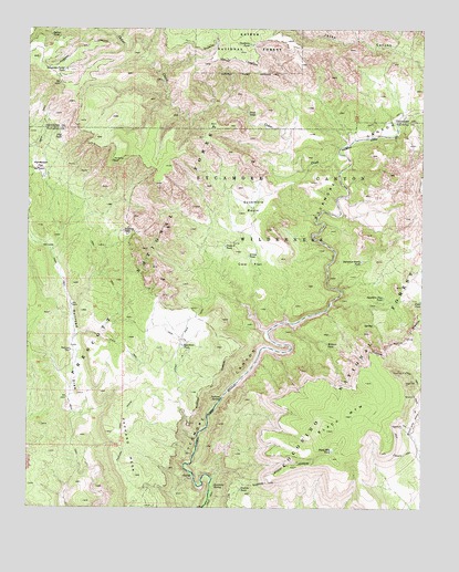
Sycamore Basin, AZ USGS Topographic Map
Click on map above to begin viewing in our Map Viewer.

This topographic map contains these locations and features:
Feature Name Type Latitude Longitude GNIS ID View Map
Arrow TankReservoirN34.9409°W112.0558°25771View Map
Black MountainSummitN34.8953°W112.0304°26425View Map
Black Mountain TankReservoirN34.8901°W112.0290°26431View Map
Cedar CreekStreamN34.9628°W112.0271°27412View Map
Cliff TankReservoirN34.9717°W112.1153°27710View Map
Cow FlatFlatN34.9384°W112.0554°28085View Map
Cross D TankReservoirN34.9432°W112.0631°28184View Map
Deadman TankReservoirN34.9960°W112.0558°28342View Map
Dogie TankReservoirN34.9290°W112.0010°28519View Map
Halfway TankReservoirN34.9474°W112.0956°29691View Map
Henderson FlatFlatN34.9645°W112.1218°29888View Map
Henderson TankReservoirN34.9618°W112.1208°41219View Map
Indian TankReservoirN34.9984°W112.1186°30380View Map
Lonesome Pocket TankReservoirN34.9892°W112.1144°31220View Map
Lost Arrow Head TankReservoirN34.9464°W112.0563°38590View Map
Ocotillo TankReservoirN34.8800°W112.0578°32478View Map
Ott WellWellN34.9722°W112.0077°41217View Map
Pack TrailTrailN34.9739°W112.1200°2091554View Map
Packard MesaSummitN34.8836°W112.0915°32615View Map
Packard TrailTrailN34.9000°W112.0949°38680View Map
Parsons SpringSpringN34.9037°W112.0643°32702View Map
Railroad TankReservoirN34.9159°W112.1116°41212View Map
Railroad WellWellN34.9078°W112.1121°2062874View Map
Sand SeepsSpringN34.9781°W112.0566°34037View Map
Summers SpringSpringN34.8807°W112.0661°34940View Map
Sycamore BasinBasinN34.9539°W112.0546°35008View Map
Sycamore Basin TankReservoirN34.9393°W112.0200°35010View Map
Sycamore Basin TrailTrailN34.9600°W112.0424°38855View Map
Sycamore Canyon WildernessReserveN34.9809°W112.0226°25505View Map
Sycamore Pass TankReservoirN34.9301°W112.0131°35040View Map
Sycamore TankReservoirN34.9174°W112.0765°35062View Map
Williams TankReservoirN34.9153°W112.0304°38954View Map
Willows TankReservoirN34.9178°W112.0306°36286View Map

Note: Coordinates in the location and feature list above are referenced to NAD83 datum.


Copyright (C) 2008-2024 Ryan Niemi / Sunset Dynamics ... All Rights Reserved