TopoQuest Logo
Do you find TopoQuest useful?
Help keep TopoQuest running and adding new maps/features by donating!
Bitcoin:  19c7KJd3qBynnjoSw5npx9KScwjBe4ifkT
Litecoin:  LXs6TkuXGGXo1vDsWCkWVdjQX94eUKd6ui
Home View Maps Find Maps Find Places Resources & Links


Perkinsville, Arizona Topographic Map

USGS Map Title: Perkinsville, AZ
USGS Map MRC: 34112H2
DRG (GeoTIFF) Download: o34112h2.tif


Neighboring USGS Topographic Map Quads:


  Matterhorn, AZ  
35112A3
 

  May Tank Pocket, AZ  
35112A2
 

  White Horse Lake, AZ  
35112A1
 

  Hell Point, AZ  
34112H3
 

  Perkinsville, AZ  
34112H2
 

  Sycamore Basin, AZ  
34112H1
 

  King Canyon, AZ  
34112G3
 

  Munds Draw, AZ  
34112G2
 

  Clarkdale, AZ  
34112G1


Map MRC Location:

N35°
W113°
N35°
W112°
H8 H7 H6 H5 H4 H3 H2 H1
G8 G7 G6 G5 G4 G3 G2 G1
F8 F7 F6 F5 F4 F3 F2 F1
E8 E7 E6 E5 E4 E3 E2 E1
D8 D7 D6 D5 D4 D3 D2 D1
C8 C7 C6 C5 C4 C3 C2 C1
B8 B7 B6 B5 B4 B3 B2 B1
A8 A7 A6 A5 A4 A3 A2 A1
N34°
W113°
N34°
W112°

Perkinsville, AZ USGS 1:24K Topographic Map Preview:
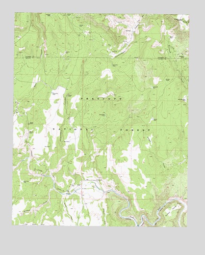
Perkinsville, AZ USGS Topographic Map
Click on map above to begin viewing in our Map Viewer.

This topographic map contains these locations and features:
Feature Name Type Latitude Longitude GNIS ID View Map
Archibald TankReservoirN34.9570°W112.1515°25734View Map
BearPopulated PlaceN34.9425°W112.2474°40947View Map
Bear Railroad StationBuildingN34.9428°W112.2482°38246View Map
Black Hills TankReservoirN34.9405°W112.1848°26396View Map
Black Mesa Number Two TankReservoirN34.8761°W112.2366°38257View Map
Boggy TankReservoirN34.9346°W112.2393°26579View Map
Bull TankReservoirN34.9840°W112.1873°37684View Map
Canyon TankReservoirN34.9514°W112.2121°27277View Map
Coyote TankReservoirN34.9865°W112.1400°40949View Map
Gale TankReservoirN34.9900°W112.1673°29242View Map
Government CanyonValleyN34.9045°W112.2235°29437View Map
Hieneken TankReservoirN34.9754°W112.1291°29958View Map
Horney TankReservoirN34.9615°W112.1422°30117View Map
Jimmy TankReservoirN34.9998°W112.2132°30544View Map
Little Sand TankReservoirN34.9714°W112.1641°38580View Map
Mark TankReservoirN34.9244°W112.2103°31515View Map
Mexican TankReservoirN34.9769°W112.2142°31787View Map
Mormon PocketFlatN34.8847°W112.1374°32051View Map
Munds DrawValleyN34.8928°W112.2132°32190View Map
Munds Trick TankReservoirN34.9189°W112.1857°40948View Map
Orchard DrawValleyN34.8942°W112.1852°32545View Map
Pass TankReservoirN34.9214°W112.2240°32707View Map
PerkinsvillePopulated PlaceN34.9017°W112.1913°32803View Map
Perkinsville Railroad StationBuildingN34.9014°W112.1902°38689View Map
Rafael DrawValleyN34.8900°W112.1402°33318View Map
Rafael TankReservoirN34.9384°W112.1510°33319View Map
Railroad Draw TankReservoirN34.9496°W112.1274°33325View Map
Sand FlatFlatN34.9772°W112.1791°34034View Map
Sand Flat TankReservoirN34.9695°W112.1803°34035View Map
Sand Trap TankReservoirN34.9006°W112.2431°34042View Map
Smokey TankReservoirN34.9926°W112.2044°34569View Map
Telephone Draw TankReservoirN34.9490°W112.1954°38866View Map
Trestle TankReservoirN34.9299°W112.2390°35464View Map
Vineyard TankReservoirN34.9986°W112.2250°35787View Map
Wildcat DrawValleyN34.8970°W112.2210°36181View Map
Witty Tom TankReservoirN34.9530°W112.2233°36349View Map

Note: Coordinates in the location and feature list above are referenced to NAD83 datum.


Copyright (C) 2008-2025 Ryan Niemi / Sunset Dynamics ... All Rights Reserved