TopoQuest Logo
Do you find TopoQuest useful?
Help keep TopoQuest running and adding new maps/features by donating!
Bitcoin:  19c7KJd3qBynnjoSw5npx9KScwjBe4ifkT
Litecoin:  LXs6TkuXGGXo1vDsWCkWVdjQX94eUKd6ui
Home View Maps Find Maps Find Places Resources & Links


Munfordville, Kentucky Topographic Map

USGS Map Title: Munfordville, KY
USGS Map MRC: 37085C8
DRG (GeoTIFF) Download: o37085c8.tif


Neighboring USGS Topographic Map Quads:


  Millerstown, KY  
37086D1
 

  Upton, KY  
37085D8
 

  Hammonville, KY  
37085D7
 

  Cub Run, KY  
37086C1
 

  Munfordville, KY  
37085C8
 

  Canmer, KY  
37085C7
 

  Mammoth Cave, KY  
37086B1
 

  Horse Cave, KY  
37085B8
 

  Park, KY  
37085B7


Map MRC Location:

N38°
W86°
N38°
W85°
H8 H7 H6 H5 H4 H3 H2 H1
G8 G7 G6 G5 G4 G3 G2 G1
F8 F7 F6 F5 F4 F3 F2 F1
E8 E7 E6 E5 E4 E3 E2 E1
D8 D7 D6 D5 D4 D3 D2 D1
C8 C7 C6 C5 C4 C3 C2 C1
B8 B7 B6 B5 B4 B3 B2 B1
A8 A7 A6 A5 A4 A3 A2 A1
N37°
W86°
N37°
W85°

Munfordville, KY USGS 1:24K Topographic Map Preview:
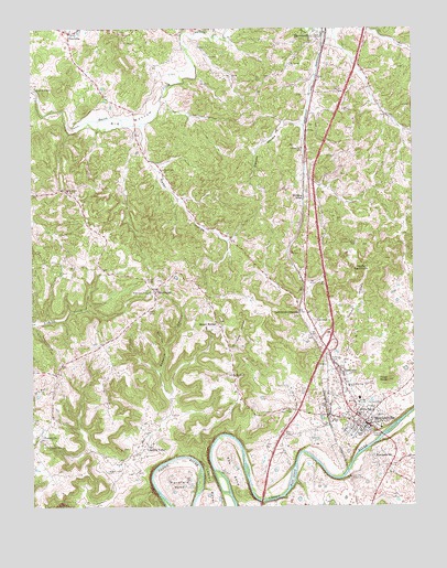
Munfordville, KY USGS Topographic Map
Click on map above to begin viewing in our Map Viewer.

This topographic map contains these locations and features:
Feature Name Type Latitude Longitude GNIS ID View Map
Bacon Creek Bridge Historical MarkerParkN37.3746°W85.9026°2744423View Map
Battle of Munfordville Historical MarkerParkN37.2535°W85.8879°2744430View Map
Battle of Rowletts Station Historical MarkerParkN37.2508°W85.8889°2744421View Map
Big BottomBendN37.3503°W85.9666°487085View Map
Campground United Methodist ChurchChurchN37.3745°W85.9420°488699View Map
Carter-Dowling SchoolSchoolN37.2817°W85.8964°489017View Map
Chestnut Grove CemeteryCemeteryN37.3189°W85.8936°489434View Map
City of MunfordvilleCivilN37.2796°W85.8983°2404340View Map
Concord ChurchChurchN37.3439°W85.9116°489930View Map
Cove HollowValleyN37.2925°W85.9574°490162View Map
Dawson HollowValleyN37.3503°W85.9166°490692View Map
Devils BackboneRidgeN37.3134°W85.8927°490836View Map
Dividing RidgeLocaleN37.3312°W85.9108°490912View Map
ForestvillePopulated PlaceN37.2684°W85.9966°508023View Map
Glen Lily Historical MarkerParkN37.2717°W85.8907°2744418View Map
Hart CountyCivilN37.2999°W85.8847°516896View Map
Hart County Ambulance ServiceBuildingN37.2764°W85.8958°2719130View Map
Hart County Historical MarkerParkN37.2715°W85.8902°2744420View Map
Hart County Sheriff's OfficeBuildingN37.2725°W85.8906°2767417View Map
Henry Clay Furnace Historical MarkerParkN37.2717°W85.8907°2744426View Map
Hubbard CemeteryCemeteryN37.2884°W85.9027°494702View Map
KessingerPopulated PlaceN37.3059°W85.9594°508384View Map
L and N Railroad Bridge Historical MarkerParkN37.2699°W85.8872°2744425View Map
Leitchfield CrossingPopulated PlaceN37.3014°W85.9125°508441View Map
Little Flock ChurchChurchN37.3328°W85.9886°496723View Map
Logsdon ValleyPopulated PlaceN37.2662°W85.9619°508492View Map
Logsdon Valley CemeteryCemeteryN37.2592°W85.9758°496992View Map
Mansfield BendBendN37.2581°W85.9525°497500View Map
Morning Star Baptist ChurchChurchN37.2753°W85.8880°498604View Map
Mount BeulahPopulated PlaceN37.2984°W85.9394°508640View Map
Mount Olivet ChurchChurchN37.2842°W85.9336°498803View Map
Mount Vernon Baptist ChurchChurchN37.3654°W85.9150°498893View Map
MunfordvillePopulated PlaceN37.2723°W85.8911°499104View Map
Munfordville DivisionCivilN37.3003°W85.9910°1937164View Map
Munfordville Fire and RescueBuildingN37.2787°W85.8959°2636426View Map
Munfordville Police DepartmentBuildingN37.2797°W85.8966°2767675View Map
Munfordville Presbyterian Church Historical MarkerParkN37.2719°W85.8912°2744419View Map
PerryvillePopulated PlaceN37.2851°W85.8983°508804View Map
Pleasant Hill ChurchChurchN37.2657°W85.9949°500864View Map
Possum HollowValleyN37.2852°W85.9582°501164View Map
PricevillePopulated PlaceN37.3742°W85.9872°501330View Map
Priceville Fire DepartmentBuildingN37.3728°W85.9873°2636616View Map
Rader HollowValleyN37.3495°W85.9636°501518View Map
Rocky Hill ChurchChurchN37.3384°W85.9569°502247View Map
Row BendBendN37.2601°W85.9344°502420View Map
Rush IslandIslandN37.2573°W85.9150°502489View Map
Skullbone HollowValleyN37.2913°W85.9310°503619View Map
Tanyard HollowValleyN37.2995°W85.8991°504948View Map
Thelma Hawkins Stovall Historical MarkerParkN37.2706°W85.8890°2744428View Map
Town KnobSummitN37.2834°W85.8830°505396View Map
Wilkerson TempleChurchN37.3064°W85.9616°506763View Map
WLOC-AM (Munfordville)TowerN37.2751°W85.9166°517643View Map
WLOC-FM (Munfordville)TowerN37.2751°W85.9166°517726View Map
WoodsonvillePopulated PlaceN37.2628°W85.8883°507125View Map

Note: Coordinates in the location and feature list above are referenced to NAD83 datum.


Copyright (C) 2008-2024 Ryan Niemi / Sunset Dynamics ... All Rights Reserved