TopoQuest Logo
Do you find TopoQuest useful?
Help keep TopoQuest running and adding new maps/features by donating!
Bitcoin:  19c7KJd3qBynnjoSw5npx9KScwjBe4ifkT
Litecoin:  LXs6TkuXGGXo1vDsWCkWVdjQX94eUKd6ui
Home View Maps Find Maps Find Places Resources & Links


Millerstown, Kentucky Topographic Map

USGS Map Title: Millerstown, KY
USGS Map MRC: 37086D1
DRG (GeoTIFF) Download: o37086d1.tif


Neighboring USGS Topographic Map Quads:


  Big Clifty, KY  
37086E2
 

  Summit, KY  
37086E1
 

  Sonora, KY  
37085E8
 

  Clarkson, KY  
37086D2
 

  Millerstown, KY  
37086D1
 

  Upton, KY  
37085D8
 

  Nolin Lake, KY  
37086C2
 

  Cub Run, KY  
37086C1
 

  Munfordville, KY  
37085C8


Map MRC Location:

N38°
W87°
N38°
W86°
H8 H7 H6 H5 H4 H3 H2 H1
G8 G7 G6 G5 G4 G3 G2 G1
F8 F7 F6 F5 F4 F3 F2 F1
E8 E7 E6 E5 E4 E3 E2 E1
D8 D7 D6 D5 D4 D3 D2 D1
C8 C7 C6 C5 C4 C3 C2 C1
B8 B7 B6 B5 B4 B3 B2 B1
A8 A7 A6 A5 A4 A3 A2 A1
N37°
W87°
N37°
W86°

Millerstown, KY USGS 1:24K Topographic Map Preview:
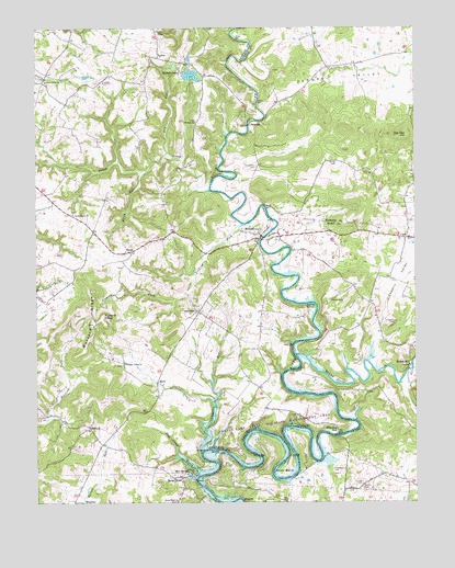
Millerstown, KY USGS Topographic Map
Click on map above to begin viewing in our Map Viewer.

This topographic map contains these locations and features:
Feature Name Type Latitude Longitude GNIS ID View Map
Akers ValleyValleyN37.4776°W86.0496°485806View Map
Berry RunStreamN37.4623°W86.0897°486915View Map
Broad FordPopulated PlaceN37.3814°W86.0794°487927View Map
Broad Ford ChurchChurchN37.3753°W86.0786°487928View Map
Bush BendBendN37.3823°W86.0439°488486View Map
Buzzard RidgeRidgeN37.4223°W86.1061°488539View Map
Buzzard RoostSummitN37.4242°W86.1025°488545View Map
Carbytown CemeteryCemeteryN37.4634°W86.0527°488919View Map
CashLocaleN37.4445°W86.0030°489054View Map
Caswell CemeteryCemeteryN37.3798°W86.0180°489081View Map
Copelin CemeteryCemeteryN37.4223°W86.0066°490075View Map
Copelin ValleyValleyN37.4109°W86.0157°490076View Map
Craddock CemeteryCemeteryN37.3839°W86.0277°490253View Map
Dry RunStreamN37.4670°W86.0814°491235View Map
Fox Den HillSummitN37.4717°W86.0025°492408View Map
HilltopPopulated PlaceN37.3951°W86.1072°508244View Map
Joyce IslandIslandN37.4276°W86.0341°495536View Map
LaconPopulated PlaceN37.4923°W86.0841°508417View Map
Laurel RunStreamN37.3884°W86.0705°496060View Map
Little Clifty ChurchChurchN37.4856°W86.1214°496672View Map
Little Flock ChurchChurchN37.4512°W86.1125°496724View Map
Lone OakPopulated PlaceN37.4256°W86.0716°508496View Map
Mill SpringSpringN37.3834°W86.0751°498294View Map
MillerstownPopulated PlaceN37.4453°W86.0508°498366View Map
Mount Zion ChurchChurchN37.4751°W86.0722°498936View Map
Nichols LakeReservoirN37.4875°W86.0736°499469View Map
Nosey CreekStreamN37.4573°W86.0676°499623View Map
Phillips CemeteryCemeteryN37.4642°W86.0258°500533View Map
Pleasant Valley ChurchChurchN37.4117°W86.0958°500930View Map
Riders MillLocaleN37.4120°W86.0019°501839View Map
Round Stone CreekStreamN37.4139°W86.0400°502412View Map
RoyalPopulated PlaceN37.4409°W86.0952°508983View Map
Sinking ForkStreamN37.4481°W86.0566°503567View Map
Slab Camp CreekStreamN37.3823°W86.0716°503625View Map
Smith CemeteryCemeteryN37.3787°W86.0177°503759View Map
SpikePopulated PlaceN37.4070°W86.0847°509109View Map
SpurrierPopulated PlaceN37.4745°W86.0541°509115View Map
Wheelers MillPopulated PlaceN37.3939°W86.0261°509350View Map
WJCR-FM (Millerstown)TowerN37.4326°W86.0305°517994View Map
Wooden CemeteryCemeteryN37.4284°W86.0283°507091View Map

Note: Coordinates in the location and feature list above are referenced to NAD83 datum.


Copyright (C) 2008-2025 Ryan Niemi / Sunset Dynamics ... All Rights Reserved