TopoQuest Logo
Do you find TopoQuest useful?
Help keep TopoQuest running and adding new maps/features by donating!
Bitcoin:  19c7KJd3qBynnjoSw5npx9KScwjBe4ifkT
Litecoin:  LXs6TkuXGGXo1vDsWCkWVdjQX94eUKd6ui
Home View Maps Find Maps Find Places Resources & Links


Mammoth Cave, Kentucky Topographic Map

USGS Map Title: Mammoth Cave, KY
USGS Map MRC: 37086B1
DRG (GeoTIFF) Download: o37086b1.tif


Neighboring USGS Topographic Map Quads:


  Nolin Lake, KY  
37086C2
 

  Cub Run, KY  
37086C1
 

  Munfordville, KY  
37085C8
 

  Rhoda, KY  
37086B2
 

  Mammoth Cave, KY  
37086B1
 

  Horse Cave, KY  
37085B8
 

  Smiths Grove, KY  
37086A2
 

  Park City, KY  
37086A1
 

  Glasgow North, KY  
37085A8


Map MRC Location:

N38°
W87°
N38°
W86°
H8 H7 H6 H5 H4 H3 H2 H1
G8 G7 G6 G5 G4 G3 G2 G1
F8 F7 F6 F5 F4 F3 F2 F1
E8 E7 E6 E5 E4 E3 E2 E1
D8 D7 D6 D5 D4 D3 D2 D1
C8 C7 C6 C5 C4 C3 C2 C1
B8 B7 B6 B5 B4 B3 B2 B1
A8 A7 A6 A5 A4 A3 A2 A1
N37°
W87°
N37°
W86°

Mammoth Cave, KY USGS 1:24K Topographic Map Preview:
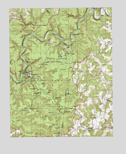
Mammoth Cave, KY USGS Topographic Map
Click on map above to begin viewing in our Map Viewer.

This topographic map contains these locations and features:
Feature Name Type Latitude Longitude GNIS ID View Map
Adwell CemeteryCemeteryN37.1956°W86.0589°485784View Map
Adwell PumphouseLocaleN37.1898°W86.0569°517085View Map
Adwell SpringSpringN37.1904°W86.0570°485785View Map
Beaver PondLakeN37.1508°W86.0991°2742735View Map
Big HollowValleyN37.2105°W86.1076°487189View Map
Big Spring HollowValleyN37.2271°W86.0727°487269View Map
Big WoodsWoodsN37.2456°W86.0591°487290View Map
Blair SpringSpringN37.2008°W86.0664°487442View Map
Bransford PumphouseLocaleN37.2017°W86.0766°517103View Map
Bransford SpringSpringN37.2008°W86.0772°487835View Map
Bruce HollowValleyN37.1781°W86.1017°488051View Map
Bush IslandIslandN37.2417°W86.0133°488490View Map
Campground CemeteryCemeteryN37.1459°W86.0214°488745View Map
Cave IslandIslandN37.1896°W86.1088°489127View Map
ChaumontPopulated PlaceN37.1287°W86.0666°507689View Map
Collins SpringSpringN37.2055°W86.0491°489874View Map
Cooper SpringSpringN37.1974°W86.0476°490064View Map
Cow Ford HollowValleyN37.2017°W86.1116°490189View Map
Daniels CemeteryCemeteryN37.2073°W86.0502°490572View Map
Deer Park HollowValleyN37.1798°W86.1200°490779View Map
Dennison FerryLocaleN37.2170°W86.0489°490817View Map
Double CellarsBasinN37.1767°W86.0847°491040View Map
Double SinksBasinN37.2056°W86.1250°491047View Map
Doyel ValleyValleyN37.1542°W86.0833°491079View Map
Doyels Big PondLakeN37.1489°W86.0718°491080View Map
Dry RunStreamN37.2478°W86.0205°491239View Map
Eaton ValleyValleyN37.1875°W86.0916°491531View Map
Echo RiverStreamN37.1803°W86.1122°491545View Map
Echo River Spring TrailTrailN37.1842°W86.1089°491546View Map
Farmers CemeteryCemeteryN37.1839°W86.0139°491990View Map
Flint RidgeRidgeN37.1976°W86.0740°492251View Map
Flint Ridge Ranger StationLocaleN37.2106°W86.0541°492252View Map
Floating Mill HollowValleyN37.1956°W86.1034°492260View Map
Floating Mill IslandIslandN37.1967°W86.1055°492261View Map
France CemeteryCemeteryN37.1292°W86.0955°492430View Map
Freedom ChurchChurchN37.2167°W86.0016°492501View Map
Goblin KnobSummitN37.2316°W86.0982°492931View Map
Great Onyx Cave PumphouseLocaleN37.2173°W86.0714°517164View Map
Great Onyx Job Corps CenterLocaleN37.2037°W86.0561°517083View Map
Green River Bluffs TrailTrailN37.1948°W86.1022°493285View Map
Hamilton ValleyValleyN37.1864°W86.0372°493626View Map
Highland SpringsPopulated PlaceN37.1314°W86.0258°508239View Map
Holton CemeteryCemeteryN37.2162°W86.0889°494440View Map
Holton HollowValleyN37.2195°W86.1047°494441View Map
Houchin HollowValleyN37.2237°W86.0655°494628View Map
Houchins ValleyValleyN37.1778°W86.0758°494630View Map
Hunter CemeteryCemeteryN37.1800°W86.0097°494783View Map
Hunts SinkBasinN37.1695°W86.0769°494797View Map
Jim Lee RidgeRidgeN37.1697°W86.0915°495267View Map
Joppa RidgeRidgeN37.1589°W86.1247°495524View Map
Katy Pace ValleyValleyN37.1403°W86.1139°495579View Map
Little Hope ChurchChurchN37.1523°W86.0491°496756View Map
Little Jordan CemeteryCemeteryN37.2334°W86.0800°496776View Map
Locust Grove CemeteryCemeteryN37.1337°W86.0691°496943View Map
Lucky IslandIslandN37.2437°W86.0314°1890185View Map
Mammoth CavePopulated PlaceN37.1862°W86.1000°508529View Map
Mammoth Cave Baptist CemeteryCemeteryN37.1978°W86.0730°1852277View Map
Mammoth Cave Baptist ChurchChurchN37.1978°W86.0730°497478View Map
Mammoth Cave RidgeRidgeN37.1550°W86.0495°497479View Map
Mammoth Cave Volunteer Fire DepartmentBuildingN37.1856°W86.1025°2637007View Map
Mammoth Dome SinkBasinN37.1831°W86.1028°497480View Map
Monroe SinkBasinN37.1362°W86.0094°498492View Map
Mount McKinley PumphouseLocaleN37.1570°W86.0700°517245View Map
Nappers RolloverCliffN37.2178°W86.1086°499172View Map
NorthtownPopulated PlaceN37.2142°W86.0008°499609View Map
Old Guides CemeteryCemeteryN37.1867°W86.1052°499829View Map
Owens ValleyValleyN37.1434°W86.1028°500081View Map
Pike SpringSpringN37.2144°W86.0556°500617View Map
Piney CreekStreamN37.2372°W86.0382°2575680View Map
Rigdon HollowValleyN37.2133°W86.1050°501856View Map
River StyxStreamN37.1870°W86.1105°504618View Map
Sand Cave Historical MarkerParkN37.1512°W86.0449°2744180View Map
Sank HollowValleyN37.2231°W86.1045°502988View Map
Sloans CrossingPopulated PlaceN37.1509°W86.0972°509081View Map
Strawberry ValleyValleyN37.1695°W86.0533°504577View Map
Sugar SinkBasinN37.2278°W86.1130°504675View Map
Taylor Coates HollowValleyN37.2028°W86.1098°505011View Map
Three Sisters HollowValleyN37.2176°W86.0606°505242View Map
Three Sisters IslandIslandN37.2184°W86.0600°505243View Map
Three SpringsSpringN37.1962°W86.0833°505245View Map
Three Springs PumphouseLocaleN37.1959°W86.0825°517296View Map
Tom Johns CrossingPopulated PlaceN37.2498°W86.0244°509219View Map
Toohey RidgeRidgeN37.1345°W86.0187°505356View Map
Ugly CreekStreamN37.2237°W86.0950°505756View Map
Union CityPopulated PlaceN37.1370°W86.0719°509259View Map
Wilkins CemeteryCemeteryN37.2412°W86.1125°506764View Map
Wilson Cave HollowValleyN37.2385°W86.0383°506884View Map
Woolsey CemeteryCemeteryN37.1414°W86.1172°507133View Map
Woolsey ValleyValleyN37.1384°W86.1178°507135View Map

Note: Coordinates in the location and feature list above are referenced to NAD83 datum.


Copyright (C) 2008-2024 Ryan Niemi / Sunset Dynamics ... All Rights Reserved