TopoQuest Logo
Do you find TopoQuest useful?
Help keep TopoQuest running and adding new maps/features by donating!
Bitcoin:  19c7KJd3qBynnjoSw5npx9KScwjBe4ifkT
Litecoin:  LXs6TkuXGGXo1vDsWCkWVdjQX94eUKd6ui
Home View Maps Find Maps Find Places Resources & Links


Murdock, Kansas Topographic Map

USGS Map Title: Murdock, KS
USGS Map MRC: 37097E8
DRG (GeoTIFF) Download: o37097e8.tif


Neighboring USGS Topographic Map Quads:


  Kingman, KS  
37098F1
 

  Waterloo, KS  
37097F8
 

  Cheney, KS  
37097F7
 

  Alameda, KS  
37098E1
 

  Murdock, KS  
37097E8
 

  Cheney SE, KS  
37097E7
 

  Rago, KS  
37098D1
 

  Adams, KS  
37097D8
 

  Norwich, KS  
37097D7


Map MRC Location:

N38°
W98°
N38°
W97°
H8 H7 H6 H5 H4 H3 H2 H1
G8 G7 G6 G5 G4 G3 G2 G1
F8 F7 F6 F5 F4 F3 F2 F1
E8 E7 E6 E5 E4 E3 E2 E1
D8 D7 D6 D5 D4 D3 D2 D1
C8 C7 C6 C5 C4 C3 C2 C1
B8 B7 B6 B5 B4 B3 B2 B1
A8 A7 A6 A5 A4 A3 A2 A1
N37°
W98°
N37°
W97°

Murdock, KS USGS 1:24K Topographic Map Preview:
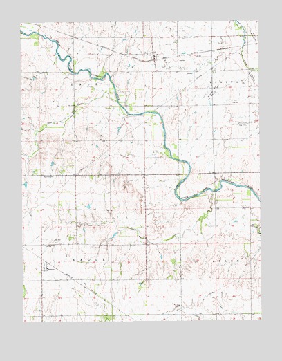
Murdock, KS USGS Topographic Map
Click on map above to begin viewing in our Map Viewer.

This topographic map contains these locations and features:
Feature Name Type Latitude Longitude GNIS ID View Map
BelmontPopulated PlaceN37.5236°W97.9892°474288View Map
Bolinger Oil FieldOilfieldN37.5820°W97.8795°474296View Map
Broadway West Oil and Gas FieldOilfieldN37.5956°W97.8995°474293View Map
Camp MennoscahLocaleN37.5956°W97.9489°474292View Map
Coon CreekStreamN37.5536°W97.8992°474287View Map
Dale School (historical)SchoolN37.5614°W97.9362°483058View Map
Dewey School (historical)SchoolN37.6183°W97.8906°483061View Map
Eagle School (historical)SchoolN37.5467°W97.9726°483056View Map
Fairview School (historical)SchoolN37.5753°W97.8984°483060View Map
Golden Rule School (historical)SchoolN37.5172°W97.9448°483057View Map
Greenwood CemeteryCemeteryN37.5606°W97.9893°474289View Map
Mabel (historical)LocaleN37.5022°W97.9581°482283View Map
MurdockPopulated PlaceN37.6111°W97.9309°474291View Map
Murdock CemeteryCemeteryN37.6231°W97.9353°474290View Map
Murdock Elementary SchoolSchoolN37.6114°W97.9337°481045View Map
Murdock Post OfficePost OfficeN37.6095°W97.9297°2693872View Map
Pleasant Hill School (historical)SchoolN37.5900°W97.9992°483059View Map
Sand CreekStreamN37.5920°W97.9498°485475View Map
Township of DaleCivilN37.6042°W97.9722°485464View Map
Township of EagleCivilN37.5169°W97.9722°470418View Map

Note: Coordinates in the location and feature list above are referenced to NAD83 datum.


Copyright (C) 2008-2025 Ryan Niemi / Sunset Dynamics ... All Rights Reserved