TopoQuest Logo
Do you find TopoQuest useful?
Help keep TopoQuest running and adding new maps/features by donating!
Bitcoin:  19c7KJd3qBynnjoSw5npx9KScwjBe4ifkT
Litecoin:  LXs6TkuXGGXo1vDsWCkWVdjQX94eUKd6ui
Home View Maps Find Maps Find Places Resources & Links


Belknap, Montana Topographic Map

USGS Map Title: Belknap, MT
USGS Map MRC: 47115F4
DRG (GeoTIFF) Download: o47115f4.tif


Neighboring USGS Topographic Map Quads:


  Trout Creek, MT  
47115G5
 

  Seven Point Mountain, MT  
47115G4
 

  Vermilion Peak, MT  
47115G3
 

  Helwick Peak, MT  
47115F5
 

  Belknap, MT  
47115F4
 

  Mount Headley, MT  
47115F3
 

  Driveway Peak, MT  
47115E5
 

  Table Top Mountain, MT  
47115E4
 

  Thompson Falls, MT  
47115E3


Map MRC Location:

N48°
W116°
N48°
W115°
H8 H7 H6 H5 H4 H3 H2 H1
G8 G7 G6 G5 G4 G3 G2 G1
F8 F7 F6 F5 F4 F3 F2 F1
E8 E7 E6 E5 E4 E3 E2 E1
D8 D7 D6 D5 D4 D3 D2 D1
C8 C7 C6 C5 C4 C3 C2 C1
B8 B7 B6 B5 B4 B3 B2 B1
A8 A7 A6 A5 A4 A3 A2 A1
N47°
W116°
N47°
W115°

Belknap, MT USGS 1:24K Topographic Map Preview:
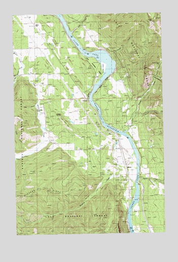
Belknap, MT USGS Topographic Map
Click on map above to begin viewing in our Map Viewer.

This topographic map contains these locations and features:
Feature Name Type Latitude Longitude GNIS ID View Map
22N30W23BDDA01 WellWellN47.6519°W115.4096°824322View Map
22N30W23DBAB01 WellWellN47.6505°W115.4035°824305View Map
22N30W24CCCC01 WellWellN47.6441°W115.3963°824257View Map
23N30W20DCCC01 WellWellN47.7316°W115.4718°824723View Map
23N30W20DCDC01 WellWellN47.7316°W115.4691°824722View Map
23N30W35DCAB01 WellWellN47.7049°W115.4043°824622View Map
BelknapPopulated PlaceN47.6622°W115.4088°779665View Map
Belknap (historical)LocaleN47.6622°W115.4088°1780975View Map
Belknap Census Designated PlaceCensusN47.6473°W115.4221°2583789View Map
Belknap Post Office (historical)Post OfficeN47.6622°W115.4088°1780953View Map
Belknap School (historical)SchoolN47.6622°W115.4088°1780835View Map
Big Beaver CreekStreamN47.7202°W115.4929°779611View Map
Blue Slide GulchValleyN47.7230°W115.4160°1780915View Map
Borax Creek MineMineN47.6722°W115.4371°804719View Map
Camp CreekStreamN47.6713°W115.4888°801784View Map
Cougar GulchValleyN47.7230°W115.4168°781755View Map
Cougar PeakSummitN47.7444°W115.3843°781756View Map
Deep CreekStreamN47.7397°W115.4535°782205View Map
Eley GulchValleyN47.6980°W115.4829°783045View Map
Enterprise Post Office (historical)Post OfficeN47.6619°W115.4085°1780954View Map
Fantom CreekStreamN47.7158°W115.4185°1780952View Map
Finley FlatsFlatN47.7227°W115.4241°783391View Map
Flatiron Ridge Fishing Access SiteLocaleN47.6352°W115.4099°1744320View Map
Flatiron Ridge Recreation SiteLocaleN47.6291°W115.4071°801790View Map
Graves CreekStreamN47.6816°W115.4088°784226View Map
Graves Creek FallsFallsN47.7209°W115.3781°784228View Map
Kildee (historical)LocaleN47.6535°W115.3982°1781026View Map
Lavell (historical)LocaleN47.6533°W115.3977°1781021View Map
Little Beaver CreekStreamN47.7202°W115.4929°786235View Map
Lucky Luke MineMineN47.6599°W115.4827°786705View Map
Marmot (historical)LocaleN47.6788°W115.4129°1781017View Map
Mosquito CreekStreamN47.6813°W115.4121°787723View Map
Pinehurst Ranch AirportAirportN47.6623°W115.4056°2650665View Map
Shannonville (historical)Populated PlaceN47.6416°W115.3954°1780992View Map
Sievers RidgeRidgeN47.6494°W115.4804°790481View Map
Sqaylth-kwum CreekStreamN47.6561°W115.3978°791378View Map
TalcPopulated PlaceN47.7202°W115.4354°791864View Map
The Blue SlideCliffN47.7144°W115.4204°792026View Map
The Rock HillSummitN47.6852°W115.4546°792052View Map
Thompson Falls Golf ClubLocaleN47.6272°W115.3996°1780914View Map
Thompson PointCapeN47.6935°W115.4874°792101View Map
Thorne CreekStreamN47.6916°W115.4004°792110View Map
White PinePopulated PlaceN47.7435°W115.4824°793202View Map
White Pine StationLocaleN47.7497°W115.4671°793208View Map
Whitepine Community Methodist ChurchChurchN47.7455°W115.4821°1780865View Map
Whitepine Post Office (historical)Post OfficeN47.7435°W115.4824°1781028View Map
Whitepine School (historical)SchoolN47.7435°W115.4824°1780834View Map
Winniemuck CreekStreamN47.7138°W115.3827°793421View Map

Note: Coordinates in the location and feature list above are referenced to NAD83 datum.


Copyright (C) 2008-2024 Ryan Niemi / Sunset Dynamics ... All Rights Reserved