TopoQuest Logo
Do you find TopoQuest useful?
Help keep TopoQuest running and adding new maps/features by donating!
Bitcoin:  19c7KJd3qBynnjoSw5npx9KScwjBe4ifkT
Litecoin:  LXs6TkuXGGXo1vDsWCkWVdjQX94eUKd6ui
Home View Maps Find Maps Find Places Resources & Links


Nashville, Illinois Topographic Map

USGS Map Title: Nashville, IL
USGS Map MRC: 38089C4
DRG (GeoTIFF) Download: o38089c4.tif


Neighboring USGS Topographic Map Quads:


  Okawville, IL  
38089D5
 

  Addieville, IL  
38089D4
 

  Hoyleton, IL  
38089D3
 

  Oakdale, IL  
38089C5
 

  Nashville, IL  
38089C4
 

  Beaucoup, IL  
38089C3
 

  Coulterville, IL  
38089B5
 

  Winkle, IL  
38089B4
 

  Todds Mill, IL  
38089B3


Map MRC Location:

N39°
W90°
N39°
W89°
H8 H7 H6 H5 H4 H3 H2 H1
G8 G7 G6 G5 G4 G3 G2 G1
F8 F7 F6 F5 F4 F3 F2 F1
E8 E7 E6 E5 E4 E3 E2 E1
D8 D7 D6 D5 D4 D3 D2 D1
C8 C7 C6 C5 C4 C3 C2 C1
B8 B7 B6 B5 B4 B3 B2 B1
A8 A7 A6 A5 A4 A3 A2 A1
N38°
W90°
N38°
W89°

Nashville, IL USGS 1:24K Topographic Map Preview:
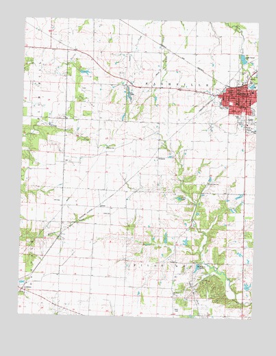
Nashville, IL USGS Topographic Map
Click on map above to begin viewing in our Map Viewer.

This topographic map contains these locations and features:
Feature Name Type Latitude Longitude GNIS ID View Map
Adams School (historical)SchoolN38.2737°W89.4168°1823750View Map
Black Diamond VineyardsBuildingN38.2658°W89.4222°2681042View Map
Brammeier Airport (historical)AirportN38.2572°W89.4716°427625View Map
City of NashvilleCivilN38.3396°W89.3777°2395154View Map
CordesPopulated PlaceN38.2962°W89.4573°422580View Map
Cordes Evangelical CemeteryCemeteryN38.2931°W89.4512°406581View Map
Cordes Oil FieldOilfieldN38.2548°W89.4040°424776View Map
Elkendier School (historical)SchoolN38.3656°W89.4629°1823761View Map
First Baptist ChurchChurchN38.3420°W89.3859°1962819View Map
First Methodist Episcopal Church (historical)ChurchN38.3420°W89.3837°1962820View Map
First Presbyterian ChurchChurchN38.3439°W89.3868°1962821View Map
Flaxbeard School (historical)SchoolN38.2801°W89.3762°1823763View Map
Forman Memorial Methodist Episcopal Church (historical)ChurchN38.3431°W89.3804°1962822View Map
Grace United Methodist ChurchChurchN38.3464°W89.3804°1962823View Map
Habbes LakeReservoirN38.3013°W89.3836°1692401View Map
Habbes Lake DamDamN38.3017°W89.3851°1692400View Map
Halfacre School (historical)SchoolN38.3442°W89.4962°1823767View Map
Harris Hill School (historical)SchoolN38.3326°W89.4462°1823768View Map
Hickory LakeReservoirN38.2712°W89.4049°410174View Map
Hickory Lake DamDamN38.2717°W89.4045°1692150View Map
Holland School (historical)SchoolN38.3195°W89.4554°1823772View Map
KempsidePopulated PlaceN38.3173°W89.4268°422868View Map
Kerr School (historical)SchoolN38.2809°W89.4515°1823779View Map
Lanes LakeLakeN38.3002°W89.4154°411806View Map
Locust Creek CemeteryCemeteryN38.3064°W89.4004°412481View Map
Locust Creek School (historical)SchoolN38.3084°W89.4223°1823784View Map
McKelvey School (historical)SchoolN38.3462°W89.4168°1823786View Map
NashvillePopulated PlaceN38.3437°W89.3806°414290View Map
Nashville Community Fire Protection DistrictBuildingN38.3435°W89.3849°2640552View Map
Nashville Community High SchoolSchoolN38.3342°W89.3790°1823787View Map
Nashville Grade SchoolSchoolN38.3412°W89.3859°1823788View Map
Nashville Police DepartmentBuildingN38.3445°W89.3824°2758904View Map
Nashville Post OfficePost OfficeN38.3430°W89.3833°1823789View Map
Nashville Public LibraryBuildingN38.3442°W89.3790°1962824View Map
Oak Grove CemeteryCemeteryN38.2595°W89.4167°414768View Map
Pilot Knob TownhallBuildingN38.2737°W89.4168°1823799View Map
Piney Wood LakeReservoirN38.2833°W89.4220°1692149View Map
Piney Wood Lake DamDamN38.2817°W89.4218°1692148View Map
Saint Annes SchoolSchoolN38.3389°W89.3815°417165View Map
Saint Pauls United Church of ChristChurchN38.3456°W89.3776°1962825View Map
Saint Peters CemeteryCemeteryN38.3212°W89.4551°417745View Map
Township of NashvilleCivilN38.3466°W89.4242°429421View Map
Township of Pilot KnobCivilN38.2588°W89.4248°429567View Map
Trinity Evangelical CemeteryCemeteryN38.3539°W89.3840°419851View Map
Trinity Evangelical Lutheran ChurchChurchN38.3453°W89.3890°1962826View Map
Trinity SchoolSchoolN38.3453°W89.3893°419871View Map
Verner Family CemeteryCemeteryN38.3323°W89.3829°420267View Map
Washington CountyCivilN38.3522°W89.4105°1785150View Map
Washington County Ambulance ServiceBuildingN38.3442°W89.3832°2674046View Map
Washington County CourthouseBuildingN38.3442°W89.3829°1823810View Map
Washington County HospitalHospitalN38.3390°W89.3912°1823811View Map
Washington County JailBuildingN38.3439°W89.3831°1962827View Map
Washington County Sheriff's OfficeBuildingN38.3451°W89.3832°2758967View Map

Note: Coordinates in the location and feature list above are referenced to NAD83 datum.


Copyright (C) 2008-2024 Ryan Niemi / Sunset Dynamics ... All Rights Reserved